| schema location: | FHRM.xsd |
| attribute form default: | |
| element form default: | qualified |
| targetNamespace: | http://water.eionet.europa.eu/schemas/dir200760ec |
| schema location: | common.xsd |
| attribute form default: | |
| element form default: | qualified |
| targetNamespace: | http://water.eionet.europa.eu/schemas/dir200760ec/fdcommon |
element FHRM
| diagram | 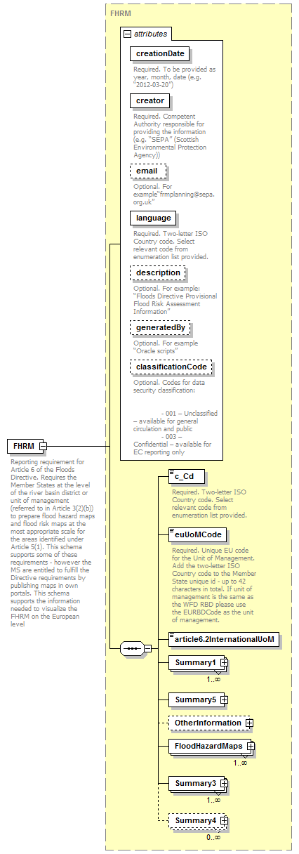 |
||||||||||||||||||||||||||||||||||||||||||||||||||||||||||||||
| namespace | http://water.eionet.europa.eu/schemas/dir200760ec | ||||||||||||||||||||||||||||||||||||||||||||||||||||||||||||||
| type | FHRM | ||||||||||||||||||||||||||||||||||||||||||||||||||||||||||||||
| properties |
|
||||||||||||||||||||||||||||||||||||||||||||||||||||||||||||||
| children | c_Cd euUoMCode article6.2InternationalUoM Summary1 Summary5 OtherInformation FloodHazardMaps Summary3 Summary4 | ||||||||||||||||||||||||||||||||||||||||||||||||||||||||||||||
| attributes |
|
||||||||||||||||||||||||||||||||||||||||||||||||||||||||||||||
| annotation |
|
||||||||||||||||||||||||||||||||||||||||||||||||||||||||||||||
| source | <xs:element name="FHRM" type="FHRM"> <xs:annotation> <xs:documentation>Reporting requirement for Article 6 of the Floods Directive. Requires the Member States at the level of the river basin district or unit of management (referred to in Article 3(2)(b)) to prepare flood hazard maps and flood risk maps at the most appropriate scale for the areas identified under Article 5(1). This schema supports some of these requirements - however the MS are entitled to fulfill the Directive requirements by publishing maps in own portals. This schema supports the information needed to visualize the FHRM on the European level</xs:documentation> </xs:annotation> </xs:element> |
complexType ArtificialWaterBearingInfrastructure
| diagram | 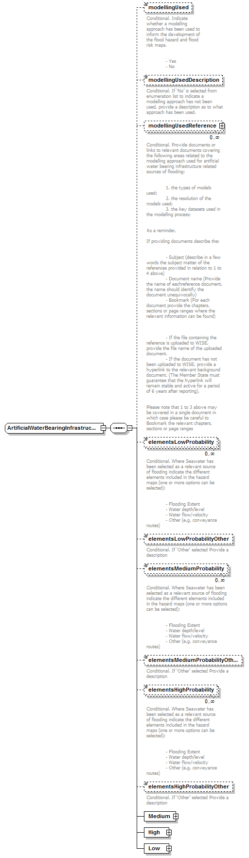 |
||
| namespace | http://water.eionet.europa.eu/schemas/dir200760ec | ||
| children | modellingUsed modellingUsedDescription modellingUsedReference elementsLowProbability elementsLowProbabilityOther elementsMediumProbability elementsMediumProbabilityOther elementsHighProbability elementsHighProbabilityOther Medium High Low | ||
| used by |
|
||
| source | <xs:complexType name="ArtificialWaterBearingInfrastructure"> <xs:sequence> <xs:element name="modellingUsed" type="fd:YesNoCode" minOccurs="0"> <xs:annotation> <xs:documentation>Conditional. Indicate whether a modelling approach has been used to inform the development of the flood hazard and flood risk maps. - Yes - No</xs:documentation> </xs:annotation> </xs:element> <xs:element name="modellingUsedDescription" type="fd:String1000Type" minOccurs="0"> <xs:annotation> <xs:documentation>Conditional. If ‘No’ is selected from enumeration list to indicate a modelling approach has not been used, provide a description as to what approach has been used.</xs:documentation> </xs:annotation> </xs:element> <xs:element name="modellingUsedReference" type="fd:ReferenceType" minOccurs="0" maxOccurs="unbounded"> <xs:annotation> <xs:documentation>Conditional. Provide documents or links to relevant documents covering the following areas related to the modelling approach used for artificial water bearing infrastructure related sources of flooding: 1. the types of models used; 2. the resolution of the models used; 3. the key datasets used in the modelling process; As a reminder, If providing documents describe the: - Subject (describe in a few words the subject matter of the references provided in relation to 1 to 4 above) - Document name (Provide the name of eachreference document, the name should identify the document unequivocally) - Bookmark (For each document provide the chapters, sections or page ranges where the relevant information can be found) - If the file containing the reference is uploaded to WISE, provide the file name of the uploaded document. - If the document has not been uploaded to WISE, provide a hyperlink to the relevant background document. (The Member State must guarantee that the hyperlink will remain stable and active for a period of 6 years after reporting). Please note that 1 to 3 above may be covered in a single document in which case please be careful to Bookmark the relevant chapters, sections or page ranges</xs:documentation> </xs:annotation> </xs:element> <xs:element name="elementsLowProbability" type="fd:ElementsProbability_Enum" minOccurs="0" maxOccurs="unbounded"> <xs:annotation> <xs:documentation>Conditional. Where Seawater has been selected as a relevant source of flooding indicate the different elements included in the hazard maps (one or more options can be selected): - Flooding Extent - Water depth/level - Water flow/velocity - Other (e.g. conveyance routes)</xs:documentation> </xs:annotation> </xs:element> <xs:element name="elementsLowProbabilityOther" type="fd:String1000Type" minOccurs="0"> <xs:annotation> <xs:documentation>Conditional. If ‘Other’ selected Provide a description</xs:documentation> </xs:annotation> </xs:element> <xs:element name="elementsMediumProbability" type="fd:ElementsProbability_Enum" minOccurs="0" maxOccurs="unbounded"> <xs:annotation> <xs:documentation>Conditional. Where Seawater has been selected as a relevant source of flooding indicate the different elements included in the hazard maps (one or more options can be selected): - Flooding Extent - Water depth/level - Water flow/velocity - Other (e.g. conveyance routes)</xs:documentation> </xs:annotation> </xs:element> <xs:element name="elementsMediumProbabilityOther" type="fd:String1000Type" minOccurs="0"> <xs:annotation> <xs:documentation>Conditional. If ‘Other’ selected Provide a description</xs:documentation> </xs:annotation> </xs:element> <xs:element name="elementsHighProbability" type="fd:ElementsProbability_Enum" minOccurs="0" maxOccurs="unbounded"> <xs:annotation> <xs:documentation>Conditional. Where Seawater has been selected as a relevant source of flooding indicate the different elements included in the hazard maps (one or more options can be selected): - Flooding Extent - Water depth/level - Water flow/velocity - Other (e.g. conveyance routes)</xs:documentation> </xs:annotation> </xs:element> <xs:element name="elementsHighProbabilityOther" type="fd:String1000Type" minOccurs="0"> <xs:annotation> <xs:documentation>Conditional. If ‘Other’ selected Provide a description</xs:documentation> </xs:annotation> </xs:element> <xs:element name="Medium" type="Medium"/> <xs:element name="High" type="High"/> <xs:element name="Low" type="Low"/> </xs:sequence> </xs:complexType> |
element ArtificialWaterBearingInfrastructure/modellingUsed
| diagram |  |
||||||||||||
| namespace | http://water.eionet.europa.eu/schemas/dir200760ec | ||||||||||||
| type | YesNoCode | ||||||||||||
| properties |
|
||||||||||||
| facets |
|
||||||||||||
| annotation |
|
||||||||||||
| source | <xs:element name="modellingUsed" type="fd:YesNoCode" minOccurs="0"> <xs:annotation> <xs:documentation>Conditional. Indicate whether a modelling approach has been used to inform the development of the flood hazard and flood risk maps. - Yes - No</xs:documentation> </xs:annotation> </xs:element> |
element ArtificialWaterBearingInfrastructure/modellingUsedDescription
| diagram |  |
|||||||||
| namespace | http://water.eionet.europa.eu/schemas/dir200760ec | |||||||||
| type | String1000Type | |||||||||
| properties |
|
|||||||||
| facets |
|
|||||||||
| annotation |
|
|||||||||
| source | <xs:element name="modellingUsedDescription" type="fd:String1000Type" minOccurs="0"> <xs:annotation> <xs:documentation>Conditional. If ‘No’ is selected from enumeration list to indicate a modelling approach has not been used, provide a description as to what approach has been used.</xs:documentation> </xs:annotation> </xs:element> |
element ArtificialWaterBearingInfrastructure/modellingUsedReference
| diagram |  |
||||||||
| namespace | http://water.eionet.europa.eu/schemas/dir200760ec | ||||||||
| type | ReferenceType | ||||||||
| properties |
|
||||||||
| children | Hyperlink FileName Bookmark DocumentName Subject | ||||||||
| annotation |
|
||||||||
| source | <xs:element name="modellingUsedReference" type="fd:ReferenceType" minOccurs="0" maxOccurs="unbounded"> <xs:annotation> <xs:documentation>Conditional. Provide documents or links to relevant documents covering the following areas related to the modelling approach used for artificial water bearing infrastructure related sources of flooding: 1. the types of models used; 2. the resolution of the models used; 3. the key datasets used in the modelling process; As a reminder, If providing documents describe the: - Subject (describe in a few words the subject matter of the references provided in relation to 1 to 4 above) - Document name (Provide the name of eachreference document, the name should identify the document unequivocally) - Bookmark (For each document provide the chapters, sections or page ranges where the relevant information can be found) - If the file containing the reference is uploaded to WISE, provide the file name of the uploaded document. - If the document has not been uploaded to WISE, provide a hyperlink to the relevant background document. (The Member State must guarantee that the hyperlink will remain stable and active for a period of 6 years after reporting). Please note that 1 to 3 above may be covered in a single document in which case please be careful to Bookmark the relevant chapters, sections or page ranges</xs:documentation> </xs:annotation> </xs:element> |
element ArtificialWaterBearingInfrastructure/elementsLowProbability
| diagram | 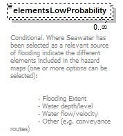 |
|||||||||||||||||||||
| namespace | http://water.eionet.europa.eu/schemas/dir200760ec | |||||||||||||||||||||
| type | ElementsProbability_Enum | |||||||||||||||||||||
| properties |
|
|||||||||||||||||||||
| facets |
|
|||||||||||||||||||||
| annotation |
|
|||||||||||||||||||||
| source | <xs:element name="elementsLowProbability" type="fd:ElementsProbability_Enum" minOccurs="0" maxOccurs="unbounded"> <xs:annotation> <xs:documentation>Conditional. Where Seawater has been selected as a relevant source of flooding indicate the different elements included in the hazard maps (one or more options can be selected): - Flooding Extent - Water depth/level - Water flow/velocity - Other (e.g. conveyance routes)</xs:documentation> </xs:annotation> </xs:element> |
element ArtificialWaterBearingInfrastructure/elementsLowProbabilityOther
| diagram |  |
|||||||||
| namespace | http://water.eionet.europa.eu/schemas/dir200760ec | |||||||||
| type | String1000Type | |||||||||
| properties |
|
|||||||||
| facets |
|
|||||||||
| annotation |
|
|||||||||
| source | <xs:element name="elementsLowProbabilityOther" type="fd:String1000Type" minOccurs="0"> <xs:annotation> <xs:documentation>Conditional. If ‘Other’ selected Provide a description</xs:documentation> </xs:annotation> </xs:element> |
element ArtificialWaterBearingInfrastructure/elementsMediumProbability
| diagram | 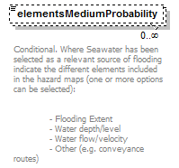 |
|||||||||||||||||||||
| namespace | http://water.eionet.europa.eu/schemas/dir200760ec | |||||||||||||||||||||
| type | ElementsProbability_Enum | |||||||||||||||||||||
| properties |
|
|||||||||||||||||||||
| facets |
|
|||||||||||||||||||||
| annotation |
|
|||||||||||||||||||||
| source | <xs:element name="elementsMediumProbability" type="fd:ElementsProbability_Enum" minOccurs="0" maxOccurs="unbounded"> <xs:annotation> <xs:documentation>Conditional. Where Seawater has been selected as a relevant source of flooding indicate the different elements included in the hazard maps (one or more options can be selected): - Flooding Extent - Water depth/level - Water flow/velocity - Other (e.g. conveyance routes)</xs:documentation> </xs:annotation> </xs:element> |
element ArtificialWaterBearingInfrastructure/elementsMediumProbabilityOther
| diagram |  |
|||||||||
| namespace | http://water.eionet.europa.eu/schemas/dir200760ec | |||||||||
| type | String1000Type | |||||||||
| properties |
|
|||||||||
| facets |
|
|||||||||
| annotation |
|
|||||||||
| source | <xs:element name="elementsMediumProbabilityOther" type="fd:String1000Type" minOccurs="0"> <xs:annotation> <xs:documentation>Conditional. If ‘Other’ selected Provide a description</xs:documentation> </xs:annotation> </xs:element> |
element ArtificialWaterBearingInfrastructure/elementsHighProbability
| diagram | 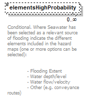 |
|||||||||||||||||||||
| namespace | http://water.eionet.europa.eu/schemas/dir200760ec | |||||||||||||||||||||
| type | ElementsProbability_Enum | |||||||||||||||||||||
| properties |
|
|||||||||||||||||||||
| facets |
|
|||||||||||||||||||||
| annotation |
|
|||||||||||||||||||||
| source | <xs:element name="elementsHighProbability" type="fd:ElementsProbability_Enum" minOccurs="0" maxOccurs="unbounded"> <xs:annotation> <xs:documentation>Conditional. Where Seawater has been selected as a relevant source of flooding indicate the different elements included in the hazard maps (one or more options can be selected): - Flooding Extent - Water depth/level - Water flow/velocity - Other (e.g. conveyance routes)</xs:documentation> </xs:annotation> </xs:element> |
element ArtificialWaterBearingInfrastructure/elementsHighProbabilityOther
| diagram |  |
|||||||||
| namespace | http://water.eionet.europa.eu/schemas/dir200760ec | |||||||||
| type | String1000Type | |||||||||
| properties |
|
|||||||||
| facets |
|
|||||||||
| annotation |
|
|||||||||
| source | <xs:element name="elementsHighProbabilityOther" type="fd:String1000Type" minOccurs="0"> <xs:annotation> <xs:documentation>Conditional. If ‘Other’ selected Provide a description</xs:documentation> </xs:annotation> </xs:element> |
element ArtificialWaterBearingInfrastructure/Medium
| diagram |  |
||||
| namespace | http://water.eionet.europa.eu/schemas/dir200760ec | ||||
| type | Medium | ||||
| properties |
|
||||
| children | FloodingExtent DepthsOrWaterLevels VelocitiesOrFlows Other | ||||
| source | <xs:element name="Medium" type="Medium"/> |
element ArtificialWaterBearingInfrastructure/High
| diagram |  |
||||
| namespace | http://water.eionet.europa.eu/schemas/dir200760ec | ||||
| type | High | ||||
| properties |
|
||||
| children | FloodingExtent DepthsOrWaterLevels VelocitiesOrFlows Other | ||||
| source | <xs:element name="High" type="High"/> |
element ArtificialWaterBearingInfrastructure/Low
| diagram |  |
||||
| namespace | http://water.eionet.europa.eu/schemas/dir200760ec | ||||
| type | Low | ||||
| properties |
|
||||
| children | FloodingExtent DepthsOrWaterLevels VelocitiesOrFlows Other | ||||
| source | <xs:element name="Low" type="Low"/> |
complexType CulturalHeritageConsequence
| diagram | 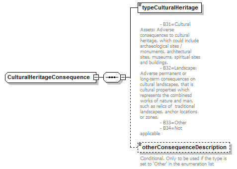 |
||
| namespace | http://water.eionet.europa.eu/schemas/dir200760ec | ||
| children | typeCulturalHeritage otherConsequenceDescription | ||
| used by |
|
||
| source | <xs:complexType name="CulturalHeritageConsequence"> <xs:sequence> <xs:element name="typeCulturalHeritage" type="fd:TypeEnvironment_Enum"> <xs:annotation> <xs:documentation> - B31=Cultural Assets: Adverse consequences to cultural heritage, which could include archaeological sites / monuments, architectural sites, museums, spiritual sites and buildings. - B32=Landscape: Adverse permanent or long-term consequences on cultural landscapes, that is cultural properties which represents the combinesd works of nature and man, such as relics of traditional landscapes, anchor locations or zones. - B33=Other - B34=Not applicable</xs:documentation> </xs:annotation> </xs:element> <xs:element name="otherConsequenceDescription" type="fd:String250Type" minOccurs="0"> <xs:annotation> <xs:documentation>Conditional. Only to be used if the type is set to 'Other' in the enumeration list</xs:documentation> </xs:annotation> </xs:element> </xs:sequence> </xs:complexType> |
element CulturalHeritageConsequence/typeCulturalHeritage
| diagram | 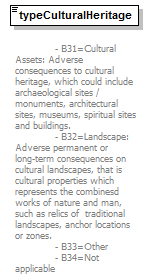 |
|||||||||||||||||||||
| namespace | http://water.eionet.europa.eu/schemas/dir200760ec | |||||||||||||||||||||
| type | TypeEnvironment_Enum | |||||||||||||||||||||
| properties |
|
|||||||||||||||||||||
| facets |
|
|||||||||||||||||||||
| annotation |
|
|||||||||||||||||||||
| source | <xs:element name="typeCulturalHeritage" type="fd:TypeEnvironment_Enum"> <xs:annotation> <xs:documentation> - B31=Cultural Assets: Adverse consequences to cultural heritage, which could include archaeological sites / monuments, architectural sites, museums, spiritual sites and buildings. - B32=Landscape: Adverse permanent or long-term consequences on cultural landscapes, that is cultural properties which represents the combinesd works of nature and man, such as relics of traditional landscapes, anchor locations or zones. - B33=Other - B34=Not applicable</xs:documentation> </xs:annotation> </xs:element> |
element CulturalHeritageConsequence/otherConsequenceDescription
| diagram | 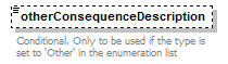 |
|||||||||
| namespace | http://water.eionet.europa.eu/schemas/dir200760ec | |||||||||
| type | String250Type | |||||||||
| properties |
|
|||||||||
| facets |
|
|||||||||
| annotation |
|
|||||||||
| source | <xs:element name="otherConsequenceDescription" type="fd:String250Type" minOccurs="0"> <xs:annotation> <xs:documentation>Conditional. Only to be used if the type is set to 'Other' in the enumeration list</xs:documentation> </xs:annotation> </xs:element> |
complexType EconomicActivity
| diagram | 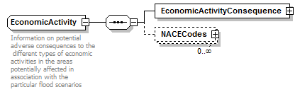 |
||
| namespace | http://water.eionet.europa.eu/schemas/dir200760ec | ||
| children | EconomicActivityConsequence NACECodes | ||
| used by |
|
||
| annotation |
|
||
| source | <xs:complexType name="EconomicActivity"> <xs:annotation> <xs:documentation>Information on potential adverse consequences to the different types of economic activities in the areas potentially affected in association with the particular flood scenarios</xs:documentation> </xs:annotation> <xs:sequence> <xs:element name="EconomicActivityConsequence" type="EconomicActivityConsequence"/> <xs:element name="NACECodes" type="NACECodes" minOccurs="0" maxOccurs="unbounded"/> </xs:sequence> </xs:complexType> |
element EconomicActivity/EconomicActivityConsequence
| diagram | 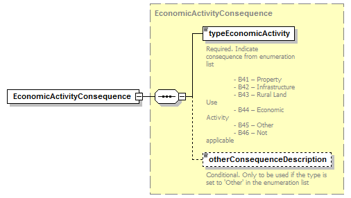 |
||||
| namespace | http://water.eionet.europa.eu/schemas/dir200760ec | ||||
| type | EconomicActivityConsequence | ||||
| properties |
|
||||
| children | typeEconomicActivity otherConsequenceDescription | ||||
| source | <xs:element name="EconomicActivityConsequence" type="EconomicActivityConsequence"/> |
element EconomicActivity/NACECodes
| diagram | 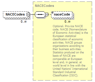 |
||||||||
| namespace | http://water.eionet.europa.eu/schemas/dir200760ec | ||||||||
| type | NACECodes | ||||||||
| properties |
|
||||||||
| children | naceCode | ||||||||
| source | <xs:element name="NACECodes" type="NACECodes" minOccurs="0" maxOccurs="unbounded"/> |
complexType EconomicActivityConsequence
| diagram | 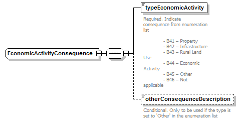 |
||
| namespace | http://water.eionet.europa.eu/schemas/dir200760ec | ||
| children | typeEconomicActivity otherConsequenceDescription | ||
| used by |
|
||
| source | <xs:complexType name="EconomicActivityConsequence"> <xs:sequence> <xs:element name="typeEconomicActivity" type="fd:TypeEconomicActivity_Enum"> <xs:annotation> <xs:documentation>Required. Indicate consequence from enumeration list - B41 – Property - B42 – Infrastructure - B43 – Rural Land Use - B44 – Economic Activity - B45 – Other - B46 – Not applicable</xs:documentation> </xs:annotation> </xs:element> <xs:element name="otherConsequenceDescription" type="fd:String250Type" minOccurs="0"> <xs:annotation> <xs:documentation>Conditional. Only to be used if the type is set to 'Other' in the enumeration list</xs:documentation> </xs:annotation> </xs:element> </xs:sequence> </xs:complexType> |
element EconomicActivityConsequence/typeEconomicActivity
| diagram | 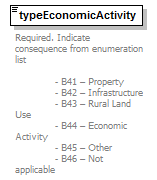 |
||||||||||||||||||||||||
| namespace | http://water.eionet.europa.eu/schemas/dir200760ec | ||||||||||||||||||||||||
| type | TypeEconomicActivity_Enum | ||||||||||||||||||||||||
| properties |
|
||||||||||||||||||||||||
| facets |
|
||||||||||||||||||||||||
| annotation |
|
||||||||||||||||||||||||
| source | <xs:element name="typeEconomicActivity" type="fd:TypeEconomicActivity_Enum"> <xs:annotation> <xs:documentation>Required. Indicate consequence from enumeration list - B41 – Property - B42 – Infrastructure - B43 – Rural Land Use - B44 – Economic Activity - B45 – Other - B46 – Not applicable</xs:documentation> </xs:annotation> </xs:element> |
element EconomicActivityConsequence/otherConsequenceDescription
| diagram |  |
|||||||||
| namespace | http://water.eionet.europa.eu/schemas/dir200760ec | |||||||||
| type | String250Type | |||||||||
| properties |
|
|||||||||
| facets |
|
|||||||||
| annotation |
|
|||||||||
| source | <xs:element name="otherConsequenceDescription" type="fd:String250Type" minOccurs="0"> <xs:annotation> <xs:documentation>Conditional. Only to be used if the type is set to 'Other' in the enumeration list</xs:documentation> </xs:annotation> </xs:element> |
complexType Environment
| diagram | 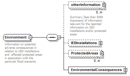 |
||
| namespace | http://water.eionet.europa.eu/schemas/dir200760ec | ||
| children | otherInformation IEDInstallations ProtectedAreas EnvironmentalConsequences | ||
| used by |
|
||
| annotation |
|
||
| source | <xs:complexType name="Environment"> <xs:annotation> <xs:documentation>Information on potential adverse consequences in relation to IED installations and affected protected areas in association with the particular flood scenarios</xs:documentation> </xs:annotation> <xs:sequence> <xs:element name="otherInformation" type="fd:ReferenceType" minOccurs="0" maxOccurs="unbounded"> <xs:annotation> <xs:documentation>Summary (less than 5000 characters) of information relevant for the reported information on IED installations and/or protected areas</xs:documentation> </xs:annotation> </xs:element> <xs:element name="IEDInstallations" type="IEDInstallations" minOccurs="0"/> <xs:element name="ProtectedAreas" type="ProtectedAreas" minOccurs="0" maxOccurs="unbounded"/> <xs:element name="EnvironmentalConsequences" type="EnvironmentalConsequences"/> </xs:sequence> </xs:complexType> |
element Environment/otherInformation
| diagram | 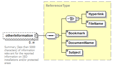 |
||||||||
| namespace | http://water.eionet.europa.eu/schemas/dir200760ec | ||||||||
| type | ReferenceType | ||||||||
| properties |
|
||||||||
| children | Hyperlink FileName Bookmark DocumentName Subject | ||||||||
| annotation |
|
||||||||
| source | <xs:element name="otherInformation" type="fd:ReferenceType" minOccurs="0" maxOccurs="unbounded"> <xs:annotation> <xs:documentation>Summary (less than 5000 characters) of information relevant for the reported information on IED installations and/or protected areas</xs:documentation> </xs:annotation> </xs:element> |
element Environment/IEDInstallations
| diagram | 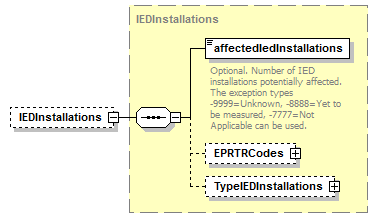 |
||||||||
| namespace | http://water.eionet.europa.eu/schemas/dir200760ec | ||||||||
| type | IEDInstallations | ||||||||
| properties |
|
||||||||
| children | affectedIedInstallations EPRTRCodes TypeIEDInstallations | ||||||||
| source | <xs:element name="IEDInstallations" type="IEDInstallations" minOccurs="0"/> |
element Environment/ProtectedAreas
| diagram | 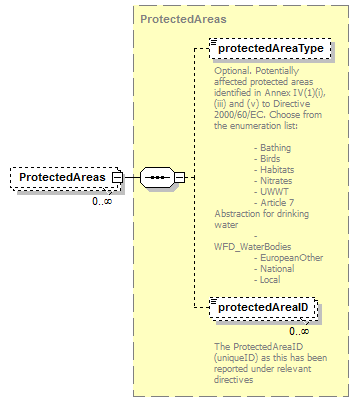 |
||||||||
| namespace | http://water.eionet.europa.eu/schemas/dir200760ec | ||||||||
| type | ProtectedAreas | ||||||||
| properties |
|
||||||||
| children | protectedAreaType protectedAreaID | ||||||||
| source | <xs:element name="ProtectedAreas" type="ProtectedAreas" minOccurs="0" maxOccurs="unbounded"/> |
element Environment/EnvironmentalConsequences
| diagram | 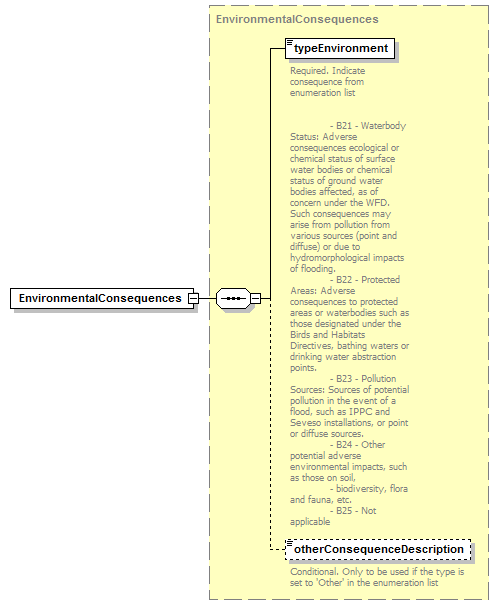 |
||||
| namespace | http://water.eionet.europa.eu/schemas/dir200760ec | ||||
| type | EnvironmentalConsequences | ||||
| properties |
|
||||
| children | typeEnvironment otherConsequenceDescription | ||||
| source | <xs:element name="EnvironmentalConsequences" type="EnvironmentalConsequences"/> |
complexType EnvironmentalConsequences
| diagram | 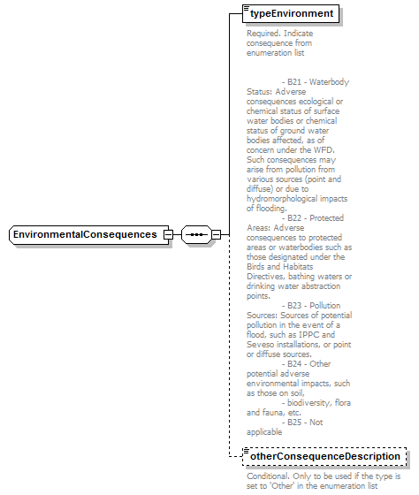 |
||
| namespace | http://water.eionet.europa.eu/schemas/dir200760ec | ||
| children | typeEnvironment otherConsequenceDescription | ||
| used by |
|
||
| source | <xs:complexType name="EnvironmentalConsequences"> <xs:sequence> <xs:element name="typeEnvironment" type="fd:TypeEnvironment_Enum"> <xs:annotation> <xs:documentation>Required. Indicate consequence from enumeration list - B21 - Waterbody Status: Adverse consequences ecological or chemical status of surface water bodies or chemical status of ground water bodies affected, as of concern under the WFD. Such consequences may arise from pollution from various sources (point and diffuse) or due to hydromorphological impacts of flooding. - B22 - Protected Areas: Adverse consequences to protected areas or waterbodies such as those designated under the Birds and Habitats Directives, bathing waters or drinking water abstraction points. - B23 - Pollution Sources: Sources of potential pollution in the event of a flood, such as IPPC and Seveso installations, or point or diffuse sources. - B24 - Other potential adverse environmental impacts, such as those on soil, - biodiversity, flora and fauna, etc. - B25 - Not applicable</xs:documentation> </xs:annotation> </xs:element> <xs:element name="otherConsequenceDescription" type="fd:String250Type" minOccurs="0"> <xs:annotation> <xs:documentation>Conditional. Only to be used if the type is set to 'Other' in the enumeration list</xs:documentation> </xs:annotation> </xs:element> </xs:sequence> </xs:complexType> |
element EnvironmentalConsequences/typeEnvironment
| diagram | 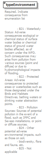 |
|||||||||||||||||||||
| namespace | http://water.eionet.europa.eu/schemas/dir200760ec | |||||||||||||||||||||
| type | TypeEnvironment_Enum | |||||||||||||||||||||
| properties |
|
|||||||||||||||||||||
| facets |
|
|||||||||||||||||||||
| annotation |
|
|||||||||||||||||||||
| source | <xs:element name="typeEnvironment" type="fd:TypeEnvironment_Enum"> <xs:annotation> <xs:documentation>Required. Indicate consequence from enumeration list - B21 - Waterbody Status: Adverse consequences ecological or chemical status of surface water bodies or chemical status of ground water bodies affected, as of concern under the WFD. Such consequences may arise from pollution from various sources (point and diffuse) or due to hydromorphological impacts of flooding. - B22 - Protected Areas: Adverse consequences to protected areas or waterbodies such as those designated under the Birds and Habitats Directives, bathing waters or drinking water abstraction points. - B23 - Pollution Sources: Sources of potential pollution in the event of a flood, such as IPPC and Seveso installations, or point or diffuse sources. - B24 - Other potential adverse environmental impacts, such as those on soil, - biodiversity, flora and fauna, etc. - B25 - Not applicable</xs:documentation> </xs:annotation> </xs:element> |
element EnvironmentalConsequences/otherConsequenceDescription
| diagram |  |
|||||||||
| namespace | http://water.eionet.europa.eu/schemas/dir200760ec | |||||||||
| type | String250Type | |||||||||
| properties |
|
|||||||||
| facets |
|
|||||||||
| annotation |
|
|||||||||
| source | <xs:element name="otherConsequenceDescription" type="fd:String250Type" minOccurs="0"> <xs:annotation> <xs:documentation>Conditional. Only to be used if the type is set to 'Other' in the enumeration list</xs:documentation> </xs:annotation> </xs:element> |
complexType EPRTRCodes
| diagram | 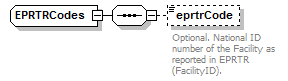 |
||
| namespace | http://water.eionet.europa.eu/schemas/dir200760ec | ||
| children | eprtrCode | ||
| used by |
|
||
| source | <xs:complexType name="EPRTRCodes"> <xs:sequence> <xs:element name="eprtrCode" type="fd:String250Type" minOccurs="0"> <xs:annotation> <xs:documentation>Optional. National ID number of the Facility as reported in EPRTR (FacilityID).</xs:documentation> </xs:annotation> </xs:element> </xs:sequence> </xs:complexType> |
element EPRTRCodes/eprtrCode
| diagram | 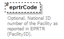 |
|||||||||
| namespace | http://water.eionet.europa.eu/schemas/dir200760ec | |||||||||
| type | String250Type | |||||||||
| properties |
|
|||||||||
| facets |
|
|||||||||
| annotation |
|
|||||||||
| source | <xs:element name="eprtrCode" type="fd:String250Type" minOccurs="0"> <xs:annotation> <xs:documentation>Optional. National ID number of the Facility as reported in EPRTR (FacilityID).</xs:documentation> </xs:annotation> </xs:element> |
complexType ExposedElement
| diagram | 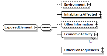 |
||
| namespace | http://water.eionet.europa.eu/schemas/dir200760ec | ||
| children | Environment InhabitantsAffected OtherInformation EconomicActivity OtherConsequences | ||
| used by |
|
||
| source | <xs:complexType name="ExposedElement"> <xs:sequence> <xs:element name="Environment" type="Environment" minOccurs="0"/> <xs:element name="InhabitantsAffected" type="InhabitantsAffected"/> <xs:element name="OtherInformation" minOccurs="0"> <xs:complexType> <xs:annotation> <xs:documentation>Other information on potential adverse consequences that the Member States considers useful in association with the particular flood scenarios</xs:documentation> </xs:annotation> <xs:sequence> <xs:element name="OtherTypeofPotentialConsequences" minOccurs="0" maxOccurs="unbounded"> <xs:complexType> <xs:sequence> <xs:element name="TypeofPotentialConsequence" type="xs:string" minOccurs="0"> <xs:annotation> <xs:documentation>Type in a potential consequence if not part of provided enumeration lists under HumanHealthSocial, Environment or Cultural Heritage</xs:documentation> </xs:annotation> </xs:element> <xs:element name="ExplanationPotentialConsequence" type="xs:string" minOccurs="0"> <xs:annotation> <xs:documentation>explanation (less than 5000 characters) new defined potential consequence</xs:documentation> </xs:annotation> </xs:element> </xs:sequence> </xs:complexType> </xs:element> <xs:element name="CulturalHeritageConsequence" minOccurs="0" maxOccurs="unbounded"> <xs:complexType> <xs:sequence> <xs:element name="TypeCulturalHeritage" type="xs:string" minOccurs="0"> <xs:annotation> <xs:documentation>Indicate consequence from enumeration list</xs:documentation> </xs:annotation> </xs:element> <xs:element name="OtherConsequenceDescription" type="xs:string" minOccurs="0"> <xs:annotation> <xs:documentation>CONDITIONAL. Only to be used if the type is set to 'Other' in the enumeration list</xs:documentation> </xs:annotation> </xs:element> </xs:sequence> </xs:complexType> </xs:element> </xs:sequence> </xs:complexType> </xs:element> <xs:element name="EconomicActivity" type="EconomicActivity" maxOccurs="unbounded"/> <xs:element name="OtherConsequences" type="OtherConsequences"/> </xs:sequence> </xs:complexType> |
element ExposedElement/Environment
| diagram | 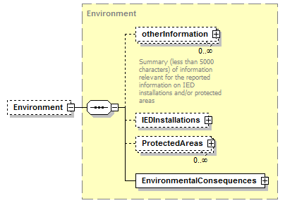 |
||||||||
| namespace | http://water.eionet.europa.eu/schemas/dir200760ec | ||||||||
| type | Environment | ||||||||
| properties |
|
||||||||
| children | otherInformation IEDInstallations ProtectedAreas EnvironmentalConsequences | ||||||||
| source | <xs:element name="Environment" type="Environment" minOccurs="0"/> |
element ExposedElement/InhabitantsAffected
| diagram | 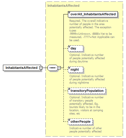 |
||||
| namespace | http://water.eionet.europa.eu/schemas/dir200760ec | ||||
| type | InhabitantsAffected | ||||
| properties |
|
||||
| children | overAll_InhabitantsAffected day night transitoryPopulation otherPeople | ||||
| source | <xs:element name="InhabitantsAffected" type="InhabitantsAffected"/> |
element ExposedElement/OtherInformation
| diagram | 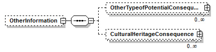 |
||||||||
| namespace | http://water.eionet.europa.eu/schemas/dir200760ec | ||||||||
| properties |
|
||||||||
| children | OtherTypeofPotentialConsequences CulturalHeritageConsequence | ||||||||
| source | <xs:element name="OtherInformation" minOccurs="0"> <xs:complexType> <xs:annotation> <xs:documentation>Other information on potential adverse consequences that the Member States considers useful in association with the particular flood scenarios</xs:documentation> </xs:annotation> <xs:sequence> <xs:element name="OtherTypeofPotentialConsequences" minOccurs="0" maxOccurs="unbounded"> <xs:complexType> <xs:sequence> <xs:element name="TypeofPotentialConsequence" type="xs:string" minOccurs="0"> <xs:annotation> <xs:documentation>Type in a potential consequence if not part of provided enumeration lists under HumanHealthSocial, Environment or Cultural Heritage</xs:documentation> </xs:annotation> </xs:element> <xs:element name="ExplanationPotentialConsequence" type="xs:string" minOccurs="0"> <xs:annotation> <xs:documentation>explanation (less than 5000 characters) new defined potential consequence</xs:documentation> </xs:annotation> </xs:element> </xs:sequence> </xs:complexType> </xs:element> <xs:element name="CulturalHeritageConsequence" minOccurs="0" maxOccurs="unbounded"> <xs:complexType> <xs:sequence> <xs:element name="TypeCulturalHeritage" type="xs:string" minOccurs="0"> <xs:annotation> <xs:documentation>Indicate consequence from enumeration list</xs:documentation> </xs:annotation> </xs:element> <xs:element name="OtherConsequenceDescription" type="xs:string" minOccurs="0"> <xs:annotation> <xs:documentation>CONDITIONAL. Only to be used if the type is set to 'Other' in the enumeration list</xs:documentation> </xs:annotation> </xs:element> </xs:sequence> </xs:complexType> </xs:element> </xs:sequence> </xs:complexType> </xs:element> |
element ExposedElement/OtherInformation/OtherTypeofPotentialConsequences
| diagram | 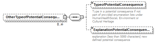 |
||||||||
| namespace | http://water.eionet.europa.eu/schemas/dir200760ec | ||||||||
| properties |
|
||||||||
| children | TypeofPotentialConsequence ExplanationPotentialConsequence | ||||||||
| source | <xs:element name="OtherTypeofPotentialConsequences" minOccurs="0" maxOccurs="unbounded"> <xs:complexType> <xs:sequence> <xs:element name="TypeofPotentialConsequence" type="xs:string" minOccurs="0"> <xs:annotation> <xs:documentation>Type in a potential consequence if not part of provided enumeration lists under HumanHealthSocial, Environment or Cultural Heritage</xs:documentation> </xs:annotation> </xs:element> <xs:element name="ExplanationPotentialConsequence" type="xs:string" minOccurs="0"> <xs:annotation> <xs:documentation>explanation (less than 5000 characters) new defined potential consequence</xs:documentation> </xs:annotation> </xs:element> </xs:sequence> </xs:complexType> </xs:element> |
element ExposedElement/OtherInformation/OtherTypeofPotentialConsequences/TypeofPotentialConsequence
| diagram | 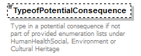 |
||||||||
| namespace | http://water.eionet.europa.eu/schemas/dir200760ec | ||||||||
| type | xs:string | ||||||||
| properties |
|
||||||||
| annotation |
|
||||||||
| source | <xs:element name="TypeofPotentialConsequence" type="xs:string" minOccurs="0"> <xs:annotation> <xs:documentation>Type in a potential consequence if not part of provided enumeration lists under HumanHealthSocial, Environment or Cultural Heritage</xs:documentation> </xs:annotation> </xs:element> |
element ExposedElement/OtherInformation/OtherTypeofPotentialConsequences/ExplanationPotentialConsequence
| diagram |  |
||||||||
| namespace | http://water.eionet.europa.eu/schemas/dir200760ec | ||||||||
| type | xs:string | ||||||||
| properties |
|
||||||||
| annotation |
|
||||||||
| source | <xs:element name="ExplanationPotentialConsequence" type="xs:string" minOccurs="0"> <xs:annotation> <xs:documentation>explanation (less than 5000 characters) new defined potential consequence</xs:documentation> </xs:annotation> </xs:element> |
element ExposedElement/OtherInformation/CulturalHeritageConsequence
| diagram | 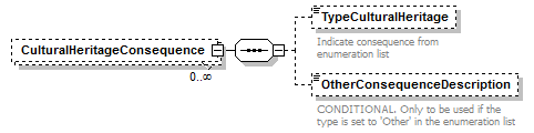 |
||||||||
| namespace | http://water.eionet.europa.eu/schemas/dir200760ec | ||||||||
| properties |
|
||||||||
| children | TypeCulturalHeritage OtherConsequenceDescription | ||||||||
| source | <xs:element name="CulturalHeritageConsequence" minOccurs="0" maxOccurs="unbounded"> <xs:complexType> <xs:sequence> <xs:element name="TypeCulturalHeritage" type="xs:string" minOccurs="0"> <xs:annotation> <xs:documentation>Indicate consequence from enumeration list</xs:documentation> </xs:annotation> </xs:element> <xs:element name="OtherConsequenceDescription" type="xs:string" minOccurs="0"> <xs:annotation> <xs:documentation>CONDITIONAL. Only to be used if the type is set to 'Other' in the enumeration list</xs:documentation> </xs:annotation> </xs:element> </xs:sequence> </xs:complexType> </xs:element> |
element ExposedElement/OtherInformation/CulturalHeritageConsequence/TypeCulturalHeritage
| diagram |  |
||||||||
| namespace | http://water.eionet.europa.eu/schemas/dir200760ec | ||||||||
| type | xs:string | ||||||||
| properties |
|
||||||||
| annotation |
|
||||||||
| source | <xs:element name="TypeCulturalHeritage" type="xs:string" minOccurs="0"> <xs:annotation> <xs:documentation>Indicate consequence from enumeration list</xs:documentation> </xs:annotation> </xs:element> |
element ExposedElement/OtherInformation/CulturalHeritageConsequence/OtherConsequenceDescription
| diagram |  |
||||||||
| namespace | http://water.eionet.europa.eu/schemas/dir200760ec | ||||||||
| type | xs:string | ||||||||
| properties |
|
||||||||
| annotation |
|
||||||||
| source | <xs:element name="OtherConsequenceDescription" type="xs:string" minOccurs="0"> <xs:annotation> <xs:documentation>CONDITIONAL. Only to be used if the type is set to 'Other' in the enumeration list</xs:documentation> </xs:annotation> </xs:element> |
element ExposedElement/EconomicActivity
| diagram | 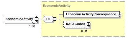 |
||||||||
| namespace | http://water.eionet.europa.eu/schemas/dir200760ec | ||||||||
| type | EconomicActivity | ||||||||
| properties |
|
||||||||
| children | EconomicActivityConsequence NACECodes | ||||||||
| source | <xs:element name="EconomicActivity" type="EconomicActivity" maxOccurs="unbounded"/> |
element ExposedElement/OtherConsequences
| diagram | 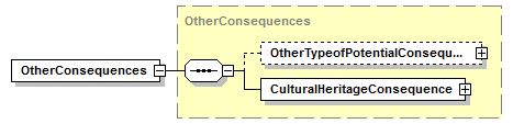 |
||||
| namespace | http://water.eionet.europa.eu/schemas/dir200760ec | ||||
| type | OtherConsequences | ||||
| properties |
|
||||
| children | OtherTypeofPotentialConsequences CulturalHeritageConsequence | ||||
| source | <xs:element name="OtherConsequences" type="OtherConsequences"/> |
complexType FHRM
| diagram | 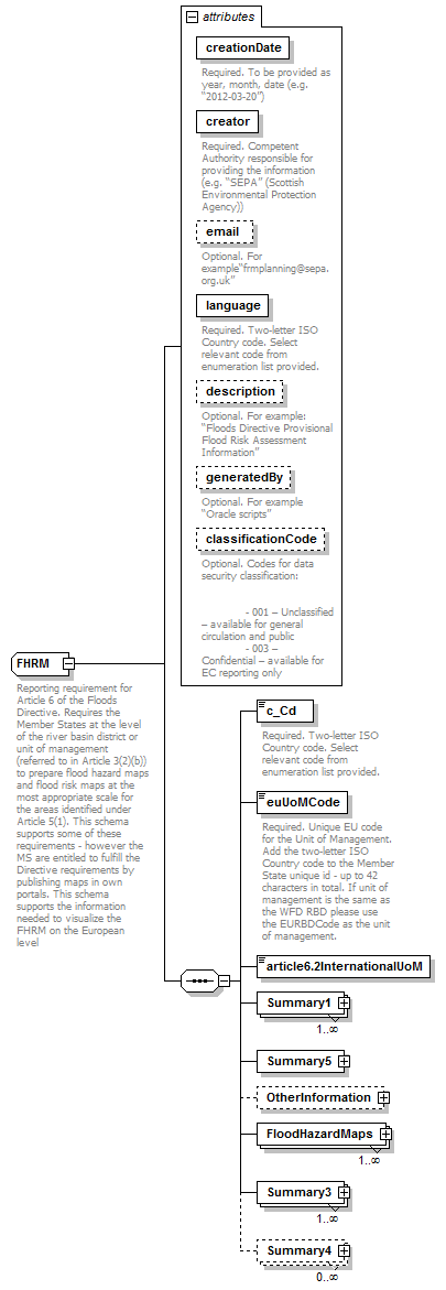 |
||||||||||||||||||||||||||||||||||||||||||||||||||||||||||||||
| namespace | http://water.eionet.europa.eu/schemas/dir200760ec | ||||||||||||||||||||||||||||||||||||||||||||||||||||||||||||||
| children | c_Cd euUoMCode article6.2InternationalUoM Summary1 Summary5 OtherInformation FloodHazardMaps Summary3 Summary4 | ||||||||||||||||||||||||||||||||||||||||||||||||||||||||||||||
| used by |
|
||||||||||||||||||||||||||||||||||||||||||||||||||||||||||||||
| attributes |
|
||||||||||||||||||||||||||||||||||||||||||||||||||||||||||||||
| annotation |
|
||||||||||||||||||||||||||||||||||||||||||||||||||||||||||||||
| source | <xs:complexType name="FHRM"> <xs:annotation> <xs:documentation>Reporting requirement for Article 6 of the Floods Directive. Requires the Member States at the level of the river basin district or unit of management (referred to in Article 3(2)(b)) to prepare flood hazard maps and flood risk maps at the most appropriate scale for the areas identified under Article 5(1). This schema supports some of these requirements - however the MS are entitled to fulfill the Directive requirements by publishing maps in own portals. This schema supports the information needed to visualize the FHRM on the European level</xs:documentation> </xs:annotation> <xs:sequence> <xs:element name="c_Cd" type="fd:CountryCode_enum"> <xs:annotation> <xs:documentation>Required. Two-letter ISO Country code. Select relevant code from enumeration list provided. </xs:documentation> </xs:annotation> </xs:element> <xs:element name="euUoMCode" type="fd:FeatureUniqueEUCodeType"> <xs:annotation> <xs:documentation>Required. Unique EU code for the Unit of Management. Add the two-letter ISO Country code to the Member State unique id - up to 42 characters in total. If unit of management is the same as the WFD RBD please use the EURBDCode as the unit of management.</xs:documentation> </xs:annotation> </xs:element> <xs:element name="article6.2InternationalUoM" type="fd:YesNoCode"/> <xs:element name="Summary1" type="Summary1" maxOccurs="unbounded"/> <xs:element name="Summary5" type="Summary5"/> <xs:element name="OtherInformation" minOccurs="0"> <xs:complexType> <xs:sequence> <xs:element name="Hyperlink" type="xs:string" minOccurs="0" maxOccurs="unbounded"> <xs:annotation> <xs:documentation>Hyperlink to more detailed supporting documents (e.g. methodology documents, external sources of information) should be provided. The link should be as specific as possible and not just to a portal.</xs:documentation> </xs:annotation> </xs:element> <xs:element name="DescriptionLink" type="xs:string" minOccurs="0" maxOccurs="unbounded"> <xs:annotation> <xs:documentation>Description of the hyperlink to more detailed supporting documents (e.g. methodology documents)</xs:documentation> </xs:annotation> </xs:element> </xs:sequence> </xs:complexType> </xs:element> <xs:element name="FloodHazardMaps" type="FloodHazardMaps" maxOccurs="unbounded"/> <xs:element name="Summary3" type="Summary3" maxOccurs="unbounded"/> <xs:element name="Summary4" type="Summary4" minOccurs="0" maxOccurs="unbounded"/> </xs:sequence> <xs:attribute name="creationDate" type="xs:string" use="required"> <xs:annotation> <xs:documentation>Required. To be provided as year, month, date (e.g. “2012-03-20”)</xs:documentation> </xs:annotation> </xs:attribute> <xs:attribute name="creator" type="xs:string" use="required"> <xs:annotation> <xs:documentation>Required. Competent Authority responsible for providing the information (e.g. “SEPA” (Scottish Environmental Protection Agency))</xs:documentation> </xs:annotation> </xs:attribute> <xs:attribute name="email" type="xs:string" use="optional"> <xs:annotation> <xs:documentation>Optional. For example“frmplanning@sepa.org.uk”</xs:documentation> </xs:annotation> </xs:attribute> <xs:attribute name="language" type="fd:LanguageCode_Enum" use="required"> <xs:annotation> <xs:documentation>Required. Two-letter ISO Country code. Select relevant code from enumeration list provided.</xs:documentation> </xs:annotation> </xs:attribute> <xs:attribute name="description" type="xs:string" use="optional"> <xs:annotation> <xs:documentation>Optional. For example: “Floods Directive Provisional Flood Risk Assessment Information”</xs:documentation> </xs:annotation> </xs:attribute> <xs:attribute name="generatedBy" type="xs:string" use="optional"> <xs:annotation> <xs:documentation>Optional. For example “Oracle scripts”</xs:documentation> </xs:annotation> </xs:attribute> <xs:attribute name="classificationCode" type="fd:DataConfidentialityClassificationCode_Enum" use="optional"> <xs:annotation> <xs:documentation>Optional. Codes for data security classification: - 001 – Unclassified – available for general circulation and public - 003 – Confidential – available for EC reporting only</xs:documentation> </xs:annotation> </xs:attribute> </xs:complexType> |
attribute FHRM/@creationDate
| type | xs:string | ||||
| properties |
|
||||
| annotation |
|
||||
| source | <xs:attribute name="creationDate" type="xs:string" use="required"> <xs:annotation> <xs:documentation>Required. To be provided as year, month, date (e.g. “2012-03-20”)</xs:documentation> </xs:annotation> </xs:attribute> |
attribute FHRM/@creator
| type | xs:string | ||||
| properties |
|
||||
| annotation |
|
||||
| source | <xs:attribute name="creator" type="xs:string" use="required"> <xs:annotation> <xs:documentation>Required. Competent Authority responsible for providing the information (e.g. “SEPA” (Scottish Environmental Protection Agency))</xs:documentation> </xs:annotation> </xs:attribute> |
attribute FHRM/@email
| type | xs:string | ||||
| properties |
|
||||
| annotation |
|
||||
| source | <xs:attribute name="email" type="xs:string" use="optional"> <xs:annotation> <xs:documentation>Optional. For example“frmplanning@sepa.org.uk”</xs:documentation> </xs:annotation> </xs:attribute> |
attribute FHRM/@language
| type | LanguageCode_Enum | |||||||||||||||||||||||||||||||||||||||||||||||||||||||||||||||||||||||||||||||||||||||
| properties |
|
|||||||||||||||||||||||||||||||||||||||||||||||||||||||||||||||||||||||||||||||||||||||
| facets |
|
|||||||||||||||||||||||||||||||||||||||||||||||||||||||||||||||||||||||||||||||||||||||
| annotation |
|
|||||||||||||||||||||||||||||||||||||||||||||||||||||||||||||||||||||||||||||||||||||||
| source | <xs:attribute name="language" type="fd:LanguageCode_Enum" use="required"> <xs:annotation> <xs:documentation>Required. Two-letter ISO Country code. Select relevant code from enumeration list provided.</xs:documentation> </xs:annotation> </xs:attribute> |
attribute FHRM/@description
| type | xs:string | ||||
| properties |
|
||||
| annotation |
|
||||
| source | <xs:attribute name="description" type="xs:string" use="optional"> <xs:annotation> <xs:documentation>Optional. For example: “Floods Directive Provisional Flood Risk Assessment Information”</xs:documentation> </xs:annotation> </xs:attribute> |
attribute FHRM/@generatedBy
| type | xs:string | ||||
| properties |
|
||||
| annotation |
|
||||
| source | <xs:attribute name="generatedBy" type="xs:string" use="optional"> <xs:annotation> <xs:documentation>Optional. For example “Oracle scripts”</xs:documentation> </xs:annotation> </xs:attribute> |
attribute FHRM/@classificationCode
| type | DataConfidentialityClassificationCode_Enum | |||||||||
| properties |
|
|||||||||
| facets |
|
|||||||||
| annotation |
|
|||||||||
| source | <xs:attribute name="classificationCode" type="fd:DataConfidentialityClassificationCode_Enum" use="optional"> <xs:annotation> <xs:documentation>Optional. Codes for data security classification: - 001 – Unclassified – available for general circulation and public - 003 – Confidential – available for EC reporting only</xs:documentation> </xs:annotation> </xs:attribute> |
element FHRM/c_Cd
| diagram | 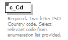 |
|||||||||||||||||||||||||||||||||||||||||||||||||||||||||||||||||||||||||||||||||||||||||||||||||||
| namespace | http://water.eionet.europa.eu/schemas/dir200760ec | |||||||||||||||||||||||||||||||||||||||||||||||||||||||||||||||||||||||||||||||||||||||||||||||||||
| type | CountryCode_enum | |||||||||||||||||||||||||||||||||||||||||||||||||||||||||||||||||||||||||||||||||||||||||||||||||||
| properties |
|
|||||||||||||||||||||||||||||||||||||||||||||||||||||||||||||||||||||||||||||||||||||||||||||||||||
| facets |
|
|||||||||||||||||||||||||||||||||||||||||||||||||||||||||||||||||||||||||||||||||||||||||||||||||||
| annotation |
|
|||||||||||||||||||||||||||||||||||||||||||||||||||||||||||||||||||||||||||||||||||||||||||||||||||
| source | <xs:element name="c_Cd" type="fd:CountryCode_enum"> <xs:annotation> <xs:documentation>Required. Two-letter ISO Country code. Select relevant code from enumeration list provided. </xs:documentation> </xs:annotation> </xs:element> |
element FHRM/euUoMCode
| diagram | 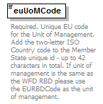 |
|||||||||
| namespace | http://water.eionet.europa.eu/schemas/dir200760ec | |||||||||
| type | FeatureUniqueEUCodeType | |||||||||
| properties |
|
|||||||||
| facets |
|
|||||||||
| annotation |
|
|||||||||
| source | <xs:element name="euUoMCode" type="fd:FeatureUniqueEUCodeType"> <xs:annotation> <xs:documentation>Required. Unique EU code for the Unit of Management. Add the two-letter ISO Country code to the Member State unique id - up to 42 characters in total. If unit of management is the same as the WFD RBD please use the EURBDCode as the unit of management.</xs:documentation> </xs:annotation> </xs:element> |
element FHRM/article6.2InternationalUoM
| diagram | |||||||||||||
| namespace | http://water.eionet.europa.eu/schemas/dir200760ec | ||||||||||||
| type | YesNoCode | ||||||||||||
| properties |
|
||||||||||||
| facets |
|
||||||||||||
| source | <xs:element name="article6.2InternationalUoM" type="fd:YesNoCode"/> |
element FHRM/Summary1
| diagram | 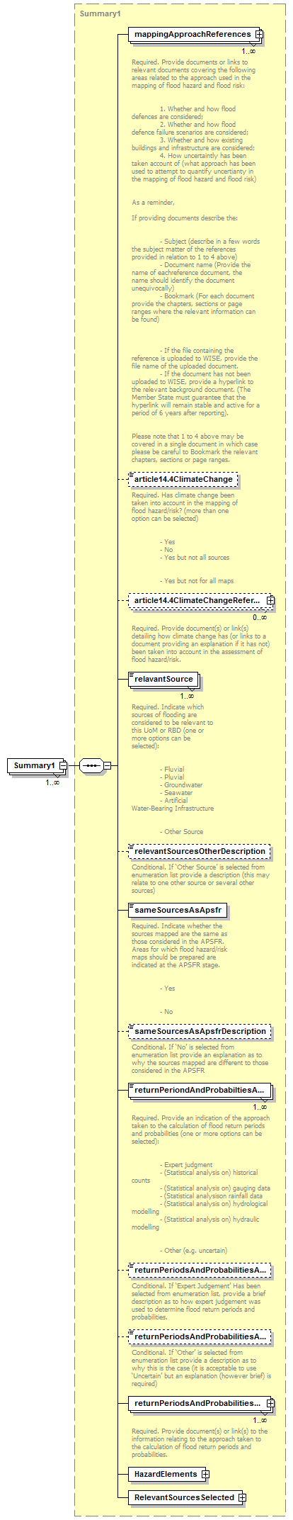 |
||||||||
| namespace | http://water.eionet.europa.eu/schemas/dir200760ec | ||||||||
| type | Summary1 | ||||||||
| properties |
|
||||||||
| children | mappingApproachReferences article14.4ClimateChange article14.4ClimateChangeReference relavantSource relevantSourcesOtherDescription sameSourcesAsApsfr sameSourcesAsApsfrDescription returnPeriondAndProbabiltiesApproach returnPeriodsAndProbabilitiesApproachExpertJudgementDescription returnPeriodsAndProbabilitiesApproachOther returnPeriodsAndProbabilitiesApproachReference HazardElements RelevantSourcesSelected | ||||||||
| source | <xs:element name="Summary1" type="Summary1" maxOccurs="unbounded"/> |
element FHRM/Summary5
| diagram | 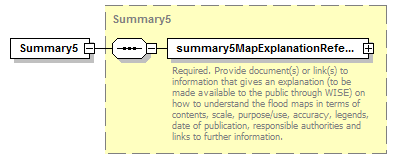 |
||||
| namespace | http://water.eionet.europa.eu/schemas/dir200760ec | ||||
| type | Summary5 | ||||
| properties |
|
||||
| children | summary5MapExplanationReference | ||||
| source | <xs:element name="Summary5" type="Summary5"/> |
element FHRM/OtherInformation
| diagram | 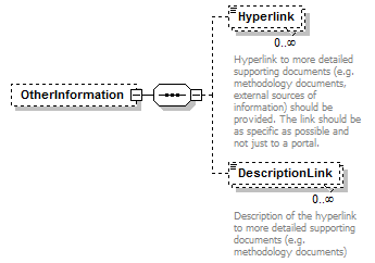 |
||||||||
| namespace | http://water.eionet.europa.eu/schemas/dir200760ec | ||||||||
| properties |
|
||||||||
| children | Hyperlink DescriptionLink | ||||||||
| source | <xs:element name="OtherInformation" minOccurs="0"> <xs:complexType> <xs:sequence> <xs:element name="Hyperlink" type="xs:string" minOccurs="0" maxOccurs="unbounded"> <xs:annotation> <xs:documentation>Hyperlink to more detailed supporting documents (e.g. methodology documents, external sources of information) should be provided. The link should be as specific as possible and not just to a portal.</xs:documentation> </xs:annotation> </xs:element> <xs:element name="DescriptionLink" type="xs:string" minOccurs="0" maxOccurs="unbounded"> <xs:annotation> <xs:documentation>Description of the hyperlink to more detailed supporting documents (e.g. methodology documents)</xs:documentation> </xs:annotation> </xs:element> </xs:sequence> </xs:complexType> </xs:element> |
element FHRM/OtherInformation/Hyperlink
| diagram | 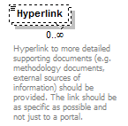 |
||||||||
| namespace | http://water.eionet.europa.eu/schemas/dir200760ec | ||||||||
| type | xs:string | ||||||||
| properties |
|
||||||||
| annotation |
|
||||||||
| source | <xs:element name="Hyperlink" type="xs:string" minOccurs="0" maxOccurs="unbounded"> <xs:annotation> <xs:documentation>Hyperlink to more detailed supporting documents (e.g. methodology documents, external sources of information) should be provided. The link should be as specific as possible and not just to a portal.</xs:documentation> </xs:annotation> </xs:element> |
element FHRM/OtherInformation/DescriptionLink
| diagram |  |
||||||||
| namespace | http://water.eionet.europa.eu/schemas/dir200760ec | ||||||||
| type | xs:string | ||||||||
| properties |
|
||||||||
| annotation |
|
||||||||
| source | <xs:element name="DescriptionLink" type="xs:string" minOccurs="0" maxOccurs="unbounded"> <xs:annotation> <xs:documentation>Description of the hyperlink to more detailed supporting documents (e.g. methodology documents)</xs:documentation> </xs:annotation> </xs:element> |
element FHRM/FloodHazardMaps
| diagram | 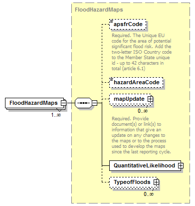 |
||||||||
| namespace | http://water.eionet.europa.eu/schemas/dir200760ec | ||||||||
| type | FloodHazardMaps | ||||||||
| properties |
|
||||||||
| children | apsfrCode hazardAreaCode mapUpdate QuantitativeLikelihood TypeofFloods | ||||||||
| source | <xs:element name="FloodHazardMaps" type="FloodHazardMaps" maxOccurs="unbounded"/> |
element FHRM/Summary3
| diagram | 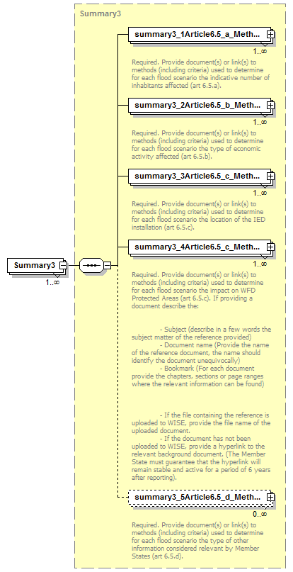 |
||||||||
| namespace | http://water.eionet.europa.eu/schemas/dir200760ec | ||||||||
| type | Summary3 | ||||||||
| properties |
|
||||||||
| children | summary3_1Article6.5_a_MethodInhabitantsAffectedReference summary3_2Article6.5_b_MethodEconomicActivityAffectedReference summary3_3Article6.5_c_MethodLocationIedInstallationReference summary3_4Article6.5_c_MethodWfdProtectedAreasReference summary3_5Article6.5_d_MethodOtherInformationReference | ||||||||
| source | <xs:element name="Summary3" type="Summary3" maxOccurs="unbounded"/> |
element FHRM/Summary4
| diagram | 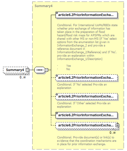 |
||||||||
| namespace | http://water.eionet.europa.eu/schemas/dir200760ec | ||||||||
| type | Summary4 | ||||||||
| properties |
|
||||||||
| children | article6.2PriorInformationExchangeOccurred article6.2PriorInformationExchangeDescription article6.2PriorInformationExchange article6.2PriorInformationExchangeOtherDescription article6.2PriorInformationExchangeReference | ||||||||
| source | <xs:element name="Summary4" type="Summary4" minOccurs="0" maxOccurs="unbounded"/> |
complexType FloodHazardMaps
| diagram | 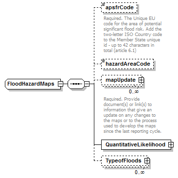 |
||
| namespace | http://water.eionet.europa.eu/schemas/dir200760ec | ||
| children | apsfrCode hazardAreaCode mapUpdate QuantitativeLikelihood TypeofFloods | ||
| used by |
|
||
| source | <xs:complexType name="FloodHazardMaps"> <xs:sequence> <xs:element name="apsfrCode" type="fd:FeatureUniqueCodeType" minOccurs="0"> <xs:annotation> <xs:documentation>Required. The Unique EU code for the area of potential significant flood risk. Add the two-letter ISO Country code to the Member State unique id - up to 42 characters in total (article 6.1)</xs:documentation> </xs:annotation> </xs:element> <xs:element name="hazardAreaCode" type="fd:FeatureUniqueCodeType" minOccurs="0"/> <xs:element name="mapUpdate" type="fd:ReferenceType" minOccurs="0" maxOccurs="unbounded"> <xs:annotation> <xs:documentation>Required. Provide document(s) or link(s) to information that give an update on any changes to the maps or to the process used to develop the maps since the last reporting cycle. </xs:documentation> </xs:annotation> </xs:element> <xs:element name="QuantitativeLikelihood" type="QuantitativeLikelihood"/> <xs:element name="TypeofFloods" type="TypeofFloods" minOccurs="0" maxOccurs="unbounded"/> </xs:sequence> </xs:complexType> |
element FloodHazardMaps/apsfrCode
| diagram | 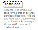 |
||||||||||||
| namespace | http://water.eionet.europa.eu/schemas/dir200760ec | ||||||||||||
| type | FeatureUniqueCodeType | ||||||||||||
| properties |
|
||||||||||||
| facets |
|
||||||||||||
| annotation |
|
||||||||||||
| source | <xs:element name="apsfrCode" type="fd:FeatureUniqueCodeType" minOccurs="0"> <xs:annotation> <xs:documentation>Required. The Unique EU code for the area of potential significant flood risk. Add the two-letter ISO Country code to the Member State unique id - up to 42 characters in total (article 6.1)</xs:documentation> </xs:annotation> </xs:element> |
element FloodHazardMaps/hazardAreaCode
| diagram | |||||||||||||
| namespace | http://water.eionet.europa.eu/schemas/dir200760ec | ||||||||||||
| type | FeatureUniqueCodeType | ||||||||||||
| properties |
|
||||||||||||
| facets |
|
||||||||||||
| source | <xs:element name="hazardAreaCode" type="fd:FeatureUniqueCodeType" minOccurs="0"/> |
element FloodHazardMaps/mapUpdate
| diagram | 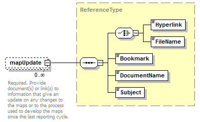 |
||||||||
| namespace | http://water.eionet.europa.eu/schemas/dir200760ec | ||||||||
| type | ReferenceType | ||||||||
| properties |
|
||||||||
| children | Hyperlink FileName Bookmark DocumentName Subject | ||||||||
| annotation |
|
||||||||
| source | <xs:element name="mapUpdate" type="fd:ReferenceType" minOccurs="0" maxOccurs="unbounded"> <xs:annotation> <xs:documentation>Required. Provide document(s) or link(s) to information that give an update on any changes to the maps or to the process used to develop the maps since the last reporting cycle. </xs:documentation> </xs:annotation> </xs:element> |
element FloodHazardMaps/QuantitativeLikelihood
| diagram | 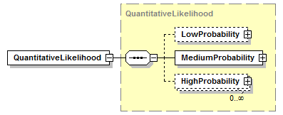 |
||||
| namespace | http://water.eionet.europa.eu/schemas/dir200760ec | ||||
| type | QuantitativeLikelihood | ||||
| properties |
|
||||
| children | LowProbability MediumProbability HighProbability | ||||
| source | <xs:element name="QuantitativeLikelihood" type="QuantitativeLikelihood"/> |
element FloodHazardMaps/TypeofFloods
| diagram | 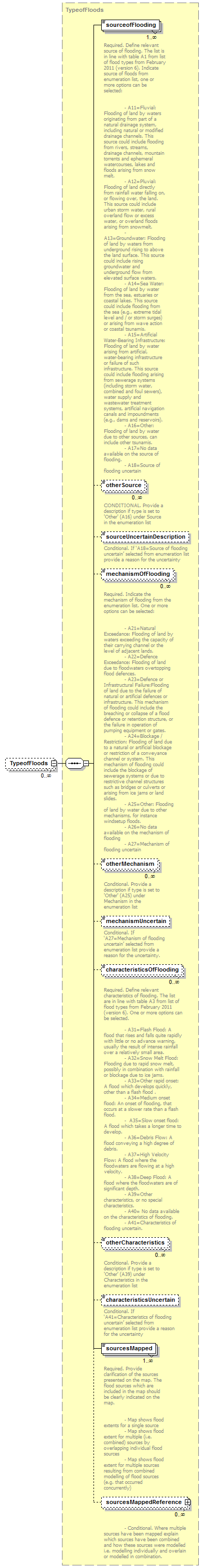 |
||||||||
| namespace | http://water.eionet.europa.eu/schemas/dir200760ec | ||||||||
| type | TypeofFloods | ||||||||
| properties |
|
||||||||
| children | sourceofFlooding otherSource sourceUncertainDescription mechanismOfFlooding otherMechanism mechanismUncertain characteristicsOfFlooding otherCharacteristics characteristicsUncertain sourcesMapped sourcesMappedReference | ||||||||
| source | <xs:element name="TypeofFloods" type="TypeofFloods" minOccurs="0" maxOccurs="unbounded"/> |
complexType FloodRiskMap
| diagram | |||
| namespace | http://water.eionet.europa.eu/schemas/dir200760ec | ||
| children | ExposedElement | ||
| used by |
|
||
| source | <xs:complexType name="FloodRiskMap"> <xs:sequence> <xs:element name="ExposedElement" type="ExposedElement"/> </xs:sequence> </xs:complexType> |
element FloodRiskMap/ExposedElement
| diagram | 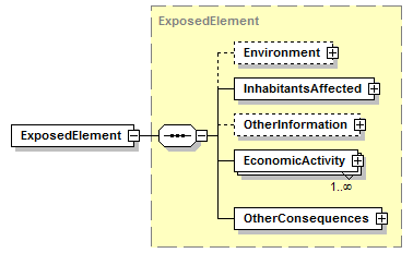 |
||||
| namespace | http://water.eionet.europa.eu/schemas/dir200760ec | ||||
| type | ExposedElement | ||||
| properties |
|
||||
| children | Environment InhabitantsAffected OtherInformation EconomicActivity OtherConsequences | ||||
| source | <xs:element name="ExposedElement" type="ExposedElement"/> |
complexType Fluvial
| diagram | 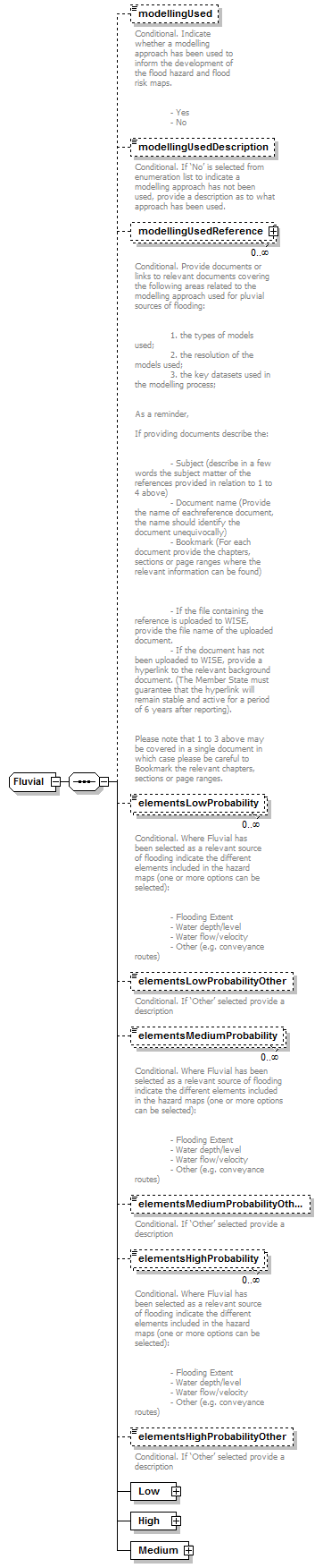 |
||
| namespace | http://water.eionet.europa.eu/schemas/dir200760ec | ||
| children | modellingUsed modellingUsedDescription modellingUsedReference elementsLowProbability elementsLowProbabilityOther elementsMediumProbability elementsMediumProbabilityOther elementsHighProbability elementsHighProbabilityOther Low High Medium | ||
| used by |
|
||
| source | <xs:complexType name="Fluvial"> <xs:sequence> <xs:element name="modellingUsed" type="fd:YesNoCode" minOccurs="0"> <xs:annotation> <xs:documentation>Conditional. Indicate whether a modelling approach has been used to inform the development of the flood hazard and flood risk maps. - Yes - No</xs:documentation> </xs:annotation> </xs:element> <xs:element name="modellingUsedDescription" type="fd:String1000Type" minOccurs="0"> <xs:annotation> <xs:documentation>Conditional. If ‘No’ is selected from enumeration list to indicate a modelling approach has not been used, provide a description as to what approach has been used.</xs:documentation> </xs:annotation> </xs:element> <xs:element name="modellingUsedReference" type="fd:ReferenceType" minOccurs="0" maxOccurs="unbounded"> <xs:annotation> <xs:documentation>Conditional. Provide documents or links to relevant documents covering the following areas related to the modelling approach used for pluvial sources of flooding: 1. the types of models used; 2. the resolution of the models used; 3. the key datasets used in the modelling process; As a reminder, If providing documents describe the: - Subject (describe in a few words the subject matter of the references provided in relation to 1 to 4 above) - Document name (Provide the name of eachreference document, the name should identify the document unequivocally) - Bookmark (For each document provide the chapters, sections or page ranges where the relevant information can be found) - If the file containing the reference is uploaded to WISE, provide the file name of the uploaded document. - If the document has not been uploaded to WISE, provide a hyperlink to the relevant background document. (The Member State must guarantee that the hyperlink will remain stable and active for a period of 6 years after reporting). Please note that 1 to 3 above may be covered in a single document in which case please be careful to Bookmark the relevant chapters, sections or page ranges. </xs:documentation> </xs:annotation> </xs:element> <xs:element name="elementsLowProbability" type="fd:ElementsProbability_Enum" minOccurs="0" maxOccurs="unbounded"> <xs:annotation> <xs:documentation>Conditional. Where Fluvial has been selected as a relevant source of flooding indicate the different elements included in the hazard maps (one or more options can be selected): - Flooding Extent - Water depth/level - Water flow/velocity - Other (e.g. conveyance routes)</xs:documentation> </xs:annotation> </xs:element> <xs:element name="elementsLowProbabilityOther" type="fd:String1000Type" minOccurs="0"> <xs:annotation> <xs:documentation>Conditional. If ‘Other’ selected provide a description</xs:documentation> </xs:annotation> </xs:element> <xs:element name="elementsMediumProbability" type="fd:ElementsProbability_Enum" minOccurs="0" maxOccurs="unbounded"> <xs:annotation> <xs:documentation>Conditional. Where Fluvial has been selected as a relevant source of flooding indicate the different elements included in the hazard maps (one or more options can be selected): - Flooding Extent - Water depth/level - Water flow/velocity - Other (e.g. conveyance routes)</xs:documentation> </xs:annotation> </xs:element> <xs:element name="elementsMediumProbabilityOther" type="fd:String1000Type" minOccurs="0"> <xs:annotation> <xs:documentation>Conditional. If ‘Other’ selected provide a description</xs:documentation> </xs:annotation> </xs:element> <xs:element name="elementsHighProbability" type="fd:ElementsProbability_Enum" minOccurs="0" maxOccurs="unbounded"> <xs:annotation> <xs:documentation>Conditional. Where Fluvial has been selected as a relevant source of flooding indicate the different elements included in the hazard maps (one or more options can be selected): - Flooding Extent - Water depth/level - Water flow/velocity - Other (e.g. conveyance routes)</xs:documentation> </xs:annotation> </xs:element> <xs:element name="elementsHighProbabilityOther" type="fd:String1000Type" minOccurs="0"> <xs:annotation> <xs:documentation>Conditional. If ‘Other’ selected provide a description</xs:documentation> </xs:annotation> </xs:element> <xs:element name="Low" type="Low"/> <xs:element name="High" type="High"/> <xs:element name="Medium" type="Medium"/> </xs:sequence> </xs:complexType> |
element Fluvial/modellingUsed
| diagram | 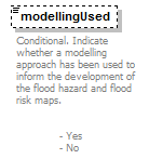 |
||||||||||||
| namespace | http://water.eionet.europa.eu/schemas/dir200760ec | ||||||||||||
| type | YesNoCode | ||||||||||||
| properties |
|
||||||||||||
| facets |
|
||||||||||||
| annotation |
|
||||||||||||
| source | <xs:element name="modellingUsed" type="fd:YesNoCode" minOccurs="0"> <xs:annotation> <xs:documentation>Conditional. Indicate whether a modelling approach has been used to inform the development of the flood hazard and flood risk maps. - Yes - No</xs:documentation> </xs:annotation> </xs:element> |
element Fluvial/modellingUsedDescription
| diagram |  |
|||||||||
| namespace | http://water.eionet.europa.eu/schemas/dir200760ec | |||||||||
| type | String1000Type | |||||||||
| properties |
|
|||||||||
| facets |
|
|||||||||
| annotation |
|
|||||||||
| source | <xs:element name="modellingUsedDescription" type="fd:String1000Type" minOccurs="0"> <xs:annotation> <xs:documentation>Conditional. If ‘No’ is selected from enumeration list to indicate a modelling approach has not been used, provide a description as to what approach has been used.</xs:documentation> </xs:annotation> </xs:element> |
element Fluvial/modellingUsedReference
| diagram |  |
||||||||
| namespace | http://water.eionet.europa.eu/schemas/dir200760ec | ||||||||
| type | ReferenceType | ||||||||
| properties |
|
||||||||
| children | Hyperlink FileName Bookmark DocumentName Subject | ||||||||
| annotation |
|
||||||||
| source | <xs:element name="modellingUsedReference" type="fd:ReferenceType" minOccurs="0" maxOccurs="unbounded"> <xs:annotation> <xs:documentation>Conditional. Provide documents or links to relevant documents covering the following areas related to the modelling approach used for pluvial sources of flooding: 1. the types of models used; 2. the resolution of the models used; 3. the key datasets used in the modelling process; As a reminder, If providing documents describe the: - Subject (describe in a few words the subject matter of the references provided in relation to 1 to 4 above) - Document name (Provide the name of eachreference document, the name should identify the document unequivocally) - Bookmark (For each document provide the chapters, sections or page ranges where the relevant information can be found) - If the file containing the reference is uploaded to WISE, provide the file name of the uploaded document. - If the document has not been uploaded to WISE, provide a hyperlink to the relevant background document. (The Member State must guarantee that the hyperlink will remain stable and active for a period of 6 years after reporting). Please note that 1 to 3 above may be covered in a single document in which case please be careful to Bookmark the relevant chapters, sections or page ranges. </xs:documentation> </xs:annotation> </xs:element> |
element Fluvial/elementsLowProbability
| diagram | 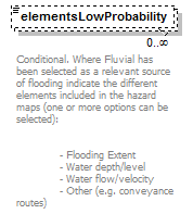 |
|||||||||||||||||||||
| namespace | http://water.eionet.europa.eu/schemas/dir200760ec | |||||||||||||||||||||
| type | ElementsProbability_Enum | |||||||||||||||||||||
| properties |
|
|||||||||||||||||||||
| facets |
|
|||||||||||||||||||||
| annotation |
|
|||||||||||||||||||||
| source | <xs:element name="elementsLowProbability" type="fd:ElementsProbability_Enum" minOccurs="0" maxOccurs="unbounded"> <xs:annotation> <xs:documentation>Conditional. Where Fluvial has been selected as a relevant source of flooding indicate the different elements included in the hazard maps (one or more options can be selected): - Flooding Extent - Water depth/level - Water flow/velocity - Other (e.g. conveyance routes)</xs:documentation> </xs:annotation> </xs:element> |
element Fluvial/elementsLowProbabilityOther
| diagram |  |
|||||||||
| namespace | http://water.eionet.europa.eu/schemas/dir200760ec | |||||||||
| type | String1000Type | |||||||||
| properties |
|
|||||||||
| facets |
|
|||||||||
| annotation |
|
|||||||||
| source | <xs:element name="elementsLowProbabilityOther" type="fd:String1000Type" minOccurs="0"> <xs:annotation> <xs:documentation>Conditional. If ‘Other’ selected provide a description</xs:documentation> </xs:annotation> </xs:element> |
element Fluvial/elementsMediumProbability
| diagram | 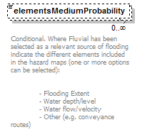 |
|||||||||||||||||||||
| namespace | http://water.eionet.europa.eu/schemas/dir200760ec | |||||||||||||||||||||
| type | ElementsProbability_Enum | |||||||||||||||||||||
| properties |
|
|||||||||||||||||||||
| facets |
|
|||||||||||||||||||||
| annotation |
|
|||||||||||||||||||||
| source | <xs:element name="elementsMediumProbability" type="fd:ElementsProbability_Enum" minOccurs="0" maxOccurs="unbounded"> <xs:annotation> <xs:documentation>Conditional. Where Fluvial has been selected as a relevant source of flooding indicate the different elements included in the hazard maps (one or more options can be selected): - Flooding Extent - Water depth/level - Water flow/velocity - Other (e.g. conveyance routes)</xs:documentation> </xs:annotation> </xs:element> |
element Fluvial/elementsMediumProbabilityOther
| diagram |  |
|||||||||
| namespace | http://water.eionet.europa.eu/schemas/dir200760ec | |||||||||
| type | String1000Type | |||||||||
| properties |
|
|||||||||
| facets |
|
|||||||||
| annotation |
|
|||||||||
| source | <xs:element name="elementsMediumProbabilityOther" type="fd:String1000Type" minOccurs="0"> <xs:annotation> <xs:documentation>Conditional. If ‘Other’ selected provide a description</xs:documentation> </xs:annotation> </xs:element> |
element Fluvial/elementsHighProbability
| diagram | 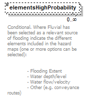 |
|||||||||||||||||||||
| namespace | http://water.eionet.europa.eu/schemas/dir200760ec | |||||||||||||||||||||
| type | ElementsProbability_Enum | |||||||||||||||||||||
| properties |
|
|||||||||||||||||||||
| facets |
|
|||||||||||||||||||||
| annotation |
|
|||||||||||||||||||||
| source | <xs:element name="elementsHighProbability" type="fd:ElementsProbability_Enum" minOccurs="0" maxOccurs="unbounded"> <xs:annotation> <xs:documentation>Conditional. Where Fluvial has been selected as a relevant source of flooding indicate the different elements included in the hazard maps (one or more options can be selected): - Flooding Extent - Water depth/level - Water flow/velocity - Other (e.g. conveyance routes)</xs:documentation> </xs:annotation> </xs:element> |
element Fluvial/elementsHighProbabilityOther
| diagram | 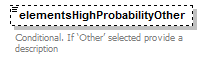 |
|||||||||
| namespace | http://water.eionet.europa.eu/schemas/dir200760ec | |||||||||
| type | String1000Type | |||||||||
| properties |
|
|||||||||
| facets |
|
|||||||||
| annotation |
|
|||||||||
| source | <xs:element name="elementsHighProbabilityOther" type="fd:String1000Type" minOccurs="0"> <xs:annotation> <xs:documentation>Conditional. If ‘Other’ selected provide a description</xs:documentation> </xs:annotation> </xs:element> |
element Fluvial/Low
| diagram | 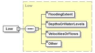 |
||||
| namespace | http://water.eionet.europa.eu/schemas/dir200760ec | ||||
| type | Low | ||||
| properties |
|
||||
| children | FloodingExtent DepthsOrWaterLevels VelocitiesOrFlows Other | ||||
| source | <xs:element name="Low" type="Low"/> |
element Fluvial/High
| diagram |  |
||||
| namespace | http://water.eionet.europa.eu/schemas/dir200760ec | ||||
| type | High | ||||
| properties |
|
||||
| children | FloodingExtent DepthsOrWaterLevels VelocitiesOrFlows Other | ||||
| source | <xs:element name="High" type="High"/> |
element Fluvial/Medium
| diagram |  |
||||
| namespace | http://water.eionet.europa.eu/schemas/dir200760ec | ||||
| type | Medium | ||||
| properties |
|
||||
| children | FloodingExtent DepthsOrWaterLevels VelocitiesOrFlows Other | ||||
| source | <xs:element name="Medium" type="Medium"/> |
complexType Groundwater
| diagram | 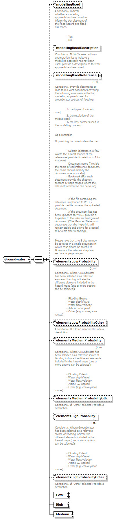 |
||
| namespace | http://water.eionet.europa.eu/schemas/dir200760ec | ||
| children | modellingUsed modellingUsedDescription modellingUsedReference elementsLowProbability elementsLowProbabilityOther elementsMediumProbability elementsMediumProbabilityOther elementsHighProbability elementsHighProbabilityOther Low High Medium | ||
| used by |
|
||
| source | <xs:complexType name="Groundwater"> <xs:sequence> <xs:element name="modellingUsed" type="fd:YesNoCode" minOccurs="0"> <xs:annotation> <xs:documentation>Conditional. Indicate whether a modelling approach has been used to inform the development of the flood hazard and flood risk maps. - Yes - No</xs:documentation> </xs:annotation> </xs:element> <xs:element name="modellingUsedDescription" type="fd:String1000Type" minOccurs="0"> <xs:annotation> <xs:documentation>Conditional. If ‘No’ is selected from enumeration list to indicate a modelling approach has not been used, provide a description as to what approach has been used.</xs:documentation> </xs:annotation> </xs:element> <xs:element name="modellingUsedReference" type="fd:ReferenceType" minOccurs="0" maxOccurs="unbounded"> <xs:annotation> <xs:documentation>Conditional. Provide documents or links to relevant documents covering the following areas related to the modelling approach used for groundwater sources of flooding: 1. the types of models used; 2. the resolution of the models used; 3. the key datasets used in the modelling process; As a reminder, If providing documents describe the: - Subject (describe in a few words the subject matter of the references provided in relation to 1 to 4 above) - Document name (Provide the name of eachreference document, the name should identify the document unequivocally) - Bookmark (For each document provide the chapters, sections or page ranges where the relevant information can be found) - If the file containing the reference is uploaded to WISE, provide the file name of the uploaded document. - If the document has not been uploaded to WISE, provide a hyperlink to the relevant background document. (The Member State must guarantee that the hyperlink will remain stable and active for a period of 6 years after reporting). Please note that 1 to 3 above may be covered in a single document in which case please be careful to Bookmark the relevant chapters, sections or page ranges. </xs:documentation> </xs:annotation> </xs:element> <xs:element name="elementsLowProbability" type="fd:ElementsProbability_Enum" minOccurs="0" maxOccurs="unbounded"> <xs:annotation> <xs:documentation>Conditional. Where Groundwater has been selected as a relevant source of flooding indicate the different elements included in the hazard maps (one or more options can be selected): - Flooding Extent - Water depth/level - Water flow/velocity - Article 6.7 applied - Other (e.g. conveyance routes)</xs:documentation> </xs:annotation> </xs:element> <xs:element name="elementsLowProbabilityOther" type="fd:String1000Type" minOccurs="0"> <xs:annotation> <xs:documentation>Conditional. If ‘Other’ selected Provide a description</xs:documentation> </xs:annotation> </xs:element> <xs:element name="elementsMediumProbability" type="fd:ElementsProbability_Enum" minOccurs="0" maxOccurs="unbounded"> <xs:annotation> <xs:documentation>Conditional. Where Groundwater has been selected as a relevant source of flooding indicate the different elements included in the hazard maps (one or more options can be selected): - Flooding Extent - Water depth/level - Water flow/velocity - Article 6.7 applied - Other (e.g. conveyance routes)</xs:documentation> </xs:annotation> </xs:element> <xs:element name="elementsMediumProbabilityOther" type="fd:String1000Type" minOccurs="0"> <xs:annotation> <xs:documentation>Conditional. If ‘Other’ selected Provide a description</xs:documentation> </xs:annotation> </xs:element> <xs:element name="elementsHighProbability" type="fd:ElementsProbability_Enum" minOccurs="0" maxOccurs="unbounded"> <xs:annotation> <xs:documentation>Conditional. Where Groundwater has been selected as a relevant source of flooding indicate the different elements included in the hazard maps (one or more options can be selected): - Flooding Extent - Water depth/level - Water flow/velocity - Article 6.7 applied - Other (e.g. conveyance routes)</xs:documentation> </xs:annotation> </xs:element> <xs:element name="elementsHighProbabilityOther" type="fd:String1000Type" minOccurs="0"> <xs:annotation> <xs:documentation>Conditional. If ‘Other’ selected Provide a description</xs:documentation> </xs:annotation> </xs:element> <xs:element name="Low" type="Low"/> <xs:element name="High" type="High"/> <xs:element name="Medium" type="Medium"/> </xs:sequence> </xs:complexType> |
element Groundwater/modellingUsed
| diagram |  |
||||||||||||
| namespace | http://water.eionet.europa.eu/schemas/dir200760ec | ||||||||||||
| type | YesNoCode | ||||||||||||
| properties |
|
||||||||||||
| facets |
|
||||||||||||
| annotation |
|
||||||||||||
| source | <xs:element name="modellingUsed" type="fd:YesNoCode" minOccurs="0"> <xs:annotation> <xs:documentation>Conditional. Indicate whether a modelling approach has been used to inform the development of the flood hazard and flood risk maps. - Yes - No</xs:documentation> </xs:annotation> </xs:element> |
element Groundwater/modellingUsedDescription
| diagram |  |
|||||||||
| namespace | http://water.eionet.europa.eu/schemas/dir200760ec | |||||||||
| type | String1000Type | |||||||||
| properties |
|
|||||||||
| facets |
|
|||||||||
| annotation |
|
|||||||||
| source | <xs:element name="modellingUsedDescription" type="fd:String1000Type" minOccurs="0"> <xs:annotation> <xs:documentation>Conditional. If ‘No’ is selected from enumeration list to indicate a modelling approach has not been used, provide a description as to what approach has been used.</xs:documentation> </xs:annotation> </xs:element> |
element Groundwater/modellingUsedReference
| diagram |  |
||||||||
| namespace | http://water.eionet.europa.eu/schemas/dir200760ec | ||||||||
| type | ReferenceType | ||||||||
| properties |
|
||||||||
| children | Hyperlink FileName Bookmark DocumentName Subject | ||||||||
| annotation |
|
||||||||
| source | <xs:element name="modellingUsedReference" type="fd:ReferenceType" minOccurs="0" maxOccurs="unbounded"> <xs:annotation> <xs:documentation>Conditional. Provide documents or links to relevant documents covering the following areas related to the modelling approach used for groundwater sources of flooding: 1. the types of models used; 2. the resolution of the models used; 3. the key datasets used in the modelling process; As a reminder, If providing documents describe the: - Subject (describe in a few words the subject matter of the references provided in relation to 1 to 4 above) - Document name (Provide the name of eachreference document, the name should identify the document unequivocally) - Bookmark (For each document provide the chapters, sections or page ranges where the relevant information can be found) - If the file containing the reference is uploaded to WISE, provide the file name of the uploaded document. - If the document has not been uploaded to WISE, provide a hyperlink to the relevant background document. (The Member State must guarantee that the hyperlink will remain stable and active for a period of 6 years after reporting). Please note that 1 to 3 above may be covered in a single document in which case please be careful to Bookmark the relevant chapters, sections or page ranges. </xs:documentation> </xs:annotation> </xs:element> |
element Groundwater/elementsLowProbability
| diagram | 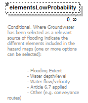 |
|||||||||||||||||||||
| namespace | http://water.eionet.europa.eu/schemas/dir200760ec | |||||||||||||||||||||
| type | ElementsProbability_Enum | |||||||||||||||||||||
| properties |
|
|||||||||||||||||||||
| facets |
|
|||||||||||||||||||||
| annotation |
|
|||||||||||||||||||||
| source | <xs:element name="elementsLowProbability" type="fd:ElementsProbability_Enum" minOccurs="0" maxOccurs="unbounded"> <xs:annotation> <xs:documentation>Conditional. Where Groundwater has been selected as a relevant source of flooding indicate the different elements included in the hazard maps (one or more options can be selected): - Flooding Extent - Water depth/level - Water flow/velocity - Article 6.7 applied - Other (e.g. conveyance routes)</xs:documentation> </xs:annotation> </xs:element> |
element Groundwater/elementsLowProbabilityOther
| diagram |  |
|||||||||
| namespace | http://water.eionet.europa.eu/schemas/dir200760ec | |||||||||
| type | String1000Type | |||||||||
| properties |
|
|||||||||
| facets |
|
|||||||||
| annotation |
|
|||||||||
| source | <xs:element name="elementsLowProbabilityOther" type="fd:String1000Type" minOccurs="0"> <xs:annotation> <xs:documentation>Conditional. If ‘Other’ selected Provide a description</xs:documentation> </xs:annotation> </xs:element> |
element Groundwater/elementsMediumProbability
| diagram | 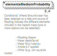 |
|||||||||||||||||||||
| namespace | http://water.eionet.europa.eu/schemas/dir200760ec | |||||||||||||||||||||
| type | ElementsProbability_Enum | |||||||||||||||||||||
| properties |
|
|||||||||||||||||||||
| facets |
|
|||||||||||||||||||||
| annotation |
|
|||||||||||||||||||||
| source | <xs:element name="elementsMediumProbability" type="fd:ElementsProbability_Enum" minOccurs="0" maxOccurs="unbounded"> <xs:annotation> <xs:documentation>Conditional. Where Groundwater has been selected as a relevant source of flooding indicate the different elements included in the hazard maps (one or more options can be selected): - Flooding Extent - Water depth/level - Water flow/velocity - Article 6.7 applied - Other (e.g. conveyance routes)</xs:documentation> </xs:annotation> </xs:element> |
element Groundwater/elementsMediumProbabilityOther
| diagram |  |
|||||||||
| namespace | http://water.eionet.europa.eu/schemas/dir200760ec | |||||||||
| type | String1000Type | |||||||||
| properties |
|
|||||||||
| facets |
|
|||||||||
| annotation |
|
|||||||||
| source | <xs:element name="elementsMediumProbabilityOther" type="fd:String1000Type" minOccurs="0"> <xs:annotation> <xs:documentation>Conditional. If ‘Other’ selected Provide a description</xs:documentation> </xs:annotation> </xs:element> |
element Groundwater/elementsHighProbability
| diagram | 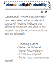 |
|||||||||||||||||||||
| namespace | http://water.eionet.europa.eu/schemas/dir200760ec | |||||||||||||||||||||
| type | ElementsProbability_Enum | |||||||||||||||||||||
| properties |
|
|||||||||||||||||||||
| facets |
|
|||||||||||||||||||||
| annotation |
|
|||||||||||||||||||||
| source | <xs:element name="elementsHighProbability" type="fd:ElementsProbability_Enum" minOccurs="0" maxOccurs="unbounded"> <xs:annotation> <xs:documentation>Conditional. Where Groundwater has been selected as a relevant source of flooding indicate the different elements included in the hazard maps (one or more options can be selected): - Flooding Extent - Water depth/level - Water flow/velocity - Article 6.7 applied - Other (e.g. conveyance routes)</xs:documentation> </xs:annotation> </xs:element> |
element Groundwater/elementsHighProbabilityOther
| diagram |  |
|||||||||
| namespace | http://water.eionet.europa.eu/schemas/dir200760ec | |||||||||
| type | String1000Type | |||||||||
| properties |
|
|||||||||
| facets |
|
|||||||||
| annotation |
|
|||||||||
| source | <xs:element name="elementsHighProbabilityOther" type="fd:String1000Type" minOccurs="0"> <xs:annotation> <xs:documentation>Conditional. If ‘Other’ selected Provide a description</xs:documentation> </xs:annotation> </xs:element> |
element Groundwater/Low
| diagram |  |
||||
| namespace | http://water.eionet.europa.eu/schemas/dir200760ec | ||||
| type | Low | ||||
| properties |
|
||||
| children | FloodingExtent DepthsOrWaterLevels VelocitiesOrFlows Other | ||||
| source | <xs:element name="Low" type="Low"/> |
element Groundwater/High
| diagram |  |
||||
| namespace | http://water.eionet.europa.eu/schemas/dir200760ec | ||||
| type | High | ||||
| properties |
|
||||
| children | FloodingExtent DepthsOrWaterLevels VelocitiesOrFlows Other | ||||
| source | <xs:element name="High" type="High"/> |
element Groundwater/Medium
| diagram |  |
||||
| namespace | http://water.eionet.europa.eu/schemas/dir200760ec | ||||
| type | Medium | ||||
| properties |
|
||||
| children | FloodingExtent DepthsOrWaterLevels VelocitiesOrFlows Other | ||||
| source | <xs:element name="Medium" type="Medium"/> |
complexType HazardElements
| diagram | 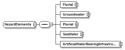 |
||
| namespace | http://water.eionet.europa.eu/schemas/dir200760ec | ||
| children | Fluvial Groundwater Pluvial SeaWater ArtificialWaterBearingInfrastructure | ||
| used by |
|
||
| source | <xs:complexType name="HazardElements"> <xs:sequence> <xs:element name="Fluvial" type="Fluvial"/> <xs:element name="Groundwater" type="Groundwater"/> <xs:element name="Pluvial" type="Pluvial"/> <xs:element name="SeaWater" type="SeaWater"/> <xs:element name="ArtificialWaterBearingInfrastructure" type="ArtificialWaterBearingInfrastructure"/> </xs:sequence> </xs:complexType> |
element HazardElements/Fluvial
| diagram |  |
||||
| namespace | http://water.eionet.europa.eu/schemas/dir200760ec | ||||
| type | Fluvial | ||||
| properties |
|
||||
| children | modellingUsed modellingUsedDescription modellingUsedReference elementsLowProbability elementsLowProbabilityOther elementsMediumProbability elementsMediumProbabilityOther elementsHighProbability elementsHighProbabilityOther Low High Medium | ||||
| source | <xs:element name="Fluvial" type="Fluvial"/> |
element HazardElements/Groundwater
| diagram | 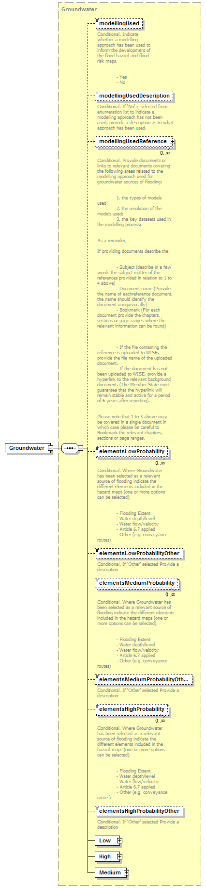 |
||||
| namespace | http://water.eionet.europa.eu/schemas/dir200760ec | ||||
| type | Groundwater | ||||
| properties |
|
||||
| children | modellingUsed modellingUsedDescription modellingUsedReference elementsLowProbability elementsLowProbabilityOther elementsMediumProbability elementsMediumProbabilityOther elementsHighProbability elementsHighProbabilityOther Low High Medium | ||||
| source | <xs:element name="Groundwater" type="Groundwater"/> |
element HazardElements/Pluvial
| diagram | 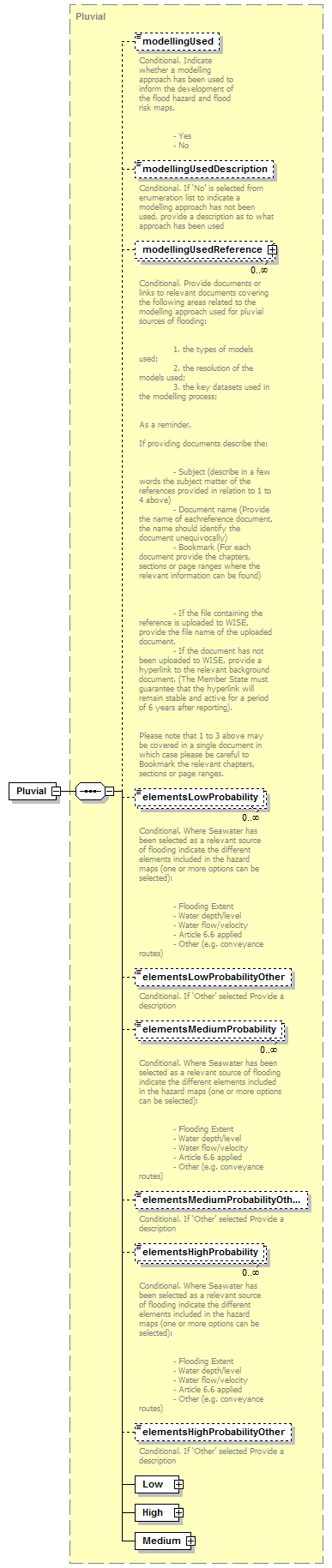 |
||||
| namespace | http://water.eionet.europa.eu/schemas/dir200760ec | ||||
| type | Pluvial | ||||
| properties |
|
||||
| children | modellingUsed modellingUsedDescription modellingUsedReference elementsLowProbability elementsLowProbabilityOther elementsMediumProbability elementsMediumProbabilityOther elementsHighProbability elementsHighProbabilityOther Low High Medium | ||||
| source | <xs:element name="Pluvial" type="Pluvial"/> |
element HazardElements/SeaWater
| diagram | 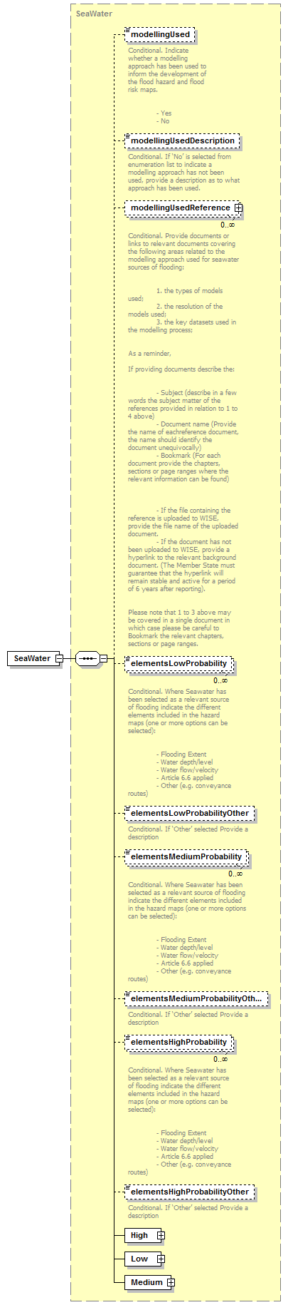 |
||||
| namespace | http://water.eionet.europa.eu/schemas/dir200760ec | ||||
| type | SeaWater | ||||
| properties |
|
||||
| children | modellingUsed modellingUsedDescription modellingUsedReference elementsLowProbability elementsLowProbabilityOther elementsMediumProbability elementsMediumProbabilityOther elementsHighProbability elementsHighProbabilityOther High Low Medium | ||||
| source | <xs:element name="SeaWater" type="SeaWater"/> |
element HazardElements/ArtificialWaterBearingInfrastructure
| diagram |  |
||||
| namespace | http://water.eionet.europa.eu/schemas/dir200760ec | ||||
| type | ArtificialWaterBearingInfrastructure | ||||
| properties |
|
||||
| children | modellingUsed modellingUsedDescription modellingUsedReference elementsLowProbability elementsLowProbabilityOther elementsMediumProbability elementsMediumProbabilityOther elementsHighProbability elementsHighProbabilityOther Medium High Low | ||||
| source | <xs:element name="ArtificialWaterBearingInfrastructure" type="ArtificialWaterBearingInfrastructure"/> |
complexType High
| diagram | 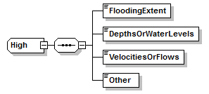 |
||
| namespace | http://water.eionet.europa.eu/schemas/dir200760ec | ||
| children | FloodingExtent DepthsOrWaterLevels VelocitiesOrFlows Other | ||
| used by |
|
||
| source | <xs:complexType name="High"> <xs:sequence> <xs:element name="FloodingExtent" type="xs:string"/> <xs:element name="DepthsOrWaterLevels" type="xs:string"/> <xs:element name="VelocitiesOrFlows" type="xs:string"/> <xs:element name="Other" type="xs:string"/> </xs:sequence> </xs:complexType> |
element High/FloodingExtent
| diagram | |||||
| namespace | http://water.eionet.europa.eu/schemas/dir200760ec | ||||
| type | xs:string | ||||
| properties |
|
||||
| source | <xs:element name="FloodingExtent" type="xs:string"/> |
element High/DepthsOrWaterLevels
| diagram | |||||
| namespace | http://water.eionet.europa.eu/schemas/dir200760ec | ||||
| type | xs:string | ||||
| properties |
|
||||
| source | <xs:element name="DepthsOrWaterLevels" type="xs:string"/> |
element High/VelocitiesOrFlows
| diagram | |||||
| namespace | http://water.eionet.europa.eu/schemas/dir200760ec | ||||
| type | xs:string | ||||
| properties |
|
||||
| source | <xs:element name="VelocitiesOrFlows" type="xs:string"/> |
element High/Other
| diagram | |||||
| namespace | http://water.eionet.europa.eu/schemas/dir200760ec | ||||
| type | xs:string | ||||
| properties |
|
||||
| source | <xs:element name="Other" type="xs:string"/> |
complexType HighProbability
| diagram | 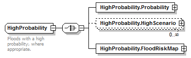 |
||
| namespace | http://water.eionet.europa.eu/schemas/dir200760ec | ||
| children | HighProbability.Probability HighProbability.HighScenario HighProbability.FloodRiskMap | ||
| used by |
|
||
| annotation |
|
||
| source | <xs:complexType name="HighProbability"> <xs:annotation> <xs:documentation>Floods with a high probability, where appropriate. </xs:documentation> </xs:annotation> <xs:choice> <xs:element name="HighProbability.Probability" type="Probability"/> <xs:element name="HighProbability.HighScenario" type="HighScenario" minOccurs="0" maxOccurs="unbounded"/> <xs:element name="HighProbability.FloodRiskMap" type="FloodRiskMap"/> </xs:choice> </xs:complexType> |
element HighProbability/HighProbability.Probability
| diagram | 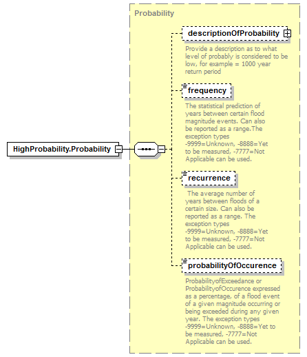 |
||||
| namespace | http://water.eionet.europa.eu/schemas/dir200760ec | ||||
| type | Probability | ||||
| properties |
|
||||
| children | descriptionOfProbability frequency recurrence probabilityOfOccurence | ||||
| source | <xs:element name="HighProbability.Probability" type="Probability"/> |
element HighProbability/HighProbability.HighScenario
| diagram | 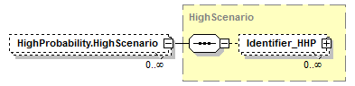 |
||||||||
| namespace | http://water.eionet.europa.eu/schemas/dir200760ec | ||||||||
| type | HighScenario | ||||||||
| properties |
|
||||||||
| children | Identifier_HHP | ||||||||
| source | <xs:element name="HighProbability.HighScenario" type="HighScenario" minOccurs="0" maxOccurs="unbounded"/> |
element HighProbability/HighProbability.FloodRiskMap
| diagram | 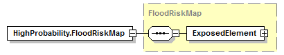 |
||||
| namespace | http://water.eionet.europa.eu/schemas/dir200760ec | ||||
| type | FloodRiskMap | ||||
| properties |
|
||||
| children | ExposedElement | ||||
| source | <xs:element name="HighProbability.FloodRiskMap" type="FloodRiskMap"/> |
complexType HighScenario
| diagram | 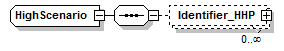 |
||
| namespace | http://water.eionet.europa.eu/schemas/dir200760ec | ||
| children | Identifier_HHP | ||
| used by |
|
||
| source | <xs:complexType name="HighScenario"> <xs:sequence> <xs:element name="Identifier_HHP" type="Identifier_HHP" minOccurs="0" maxOccurs="unbounded"/> </xs:sequence> </xs:complexType> |
element HighScenario/Identifier_HHP
| diagram | 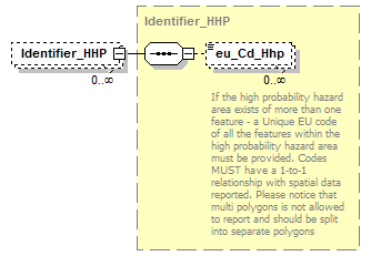 |
||||||||
| namespace | http://water.eionet.europa.eu/schemas/dir200760ec | ||||||||
| type | Identifier_HHP | ||||||||
| properties |
|
||||||||
| children | eu_Cd_Hhp | ||||||||
| source | <xs:element name="Identifier_HHP" type="Identifier_HHP" minOccurs="0" maxOccurs="unbounded"/> |
complexType Identifier_HHP
| diagram | 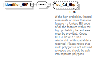 |
||
| namespace | http://water.eionet.europa.eu/schemas/dir200760ec | ||
| children | eu_Cd_Hhp | ||
| used by |
|
||
| source | <xs:complexType name="Identifier_HHP"> <xs:sequence> <xs:element name="eu_Cd_Hhp" type="fd:FeatureUniqueCodeType" minOccurs="0" maxOccurs="unbounded"> <xs:annotation> <xs:documentation>If the high probability hazard area exists of more than one feature - a Unique EU code of all the features within the high probability hazard area must be provided. Codes MUST have a 1-to-1 relationship with spatial data reported. Please notice that multi polygons is not allowed to report and should be split into separate polygons</xs:documentation> </xs:annotation> </xs:element> </xs:sequence> </xs:complexType> |
element Identifier_HHP/eu_Cd_Hhp
| diagram | 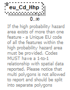 |
||||||||||||
| namespace | http://water.eionet.europa.eu/schemas/dir200760ec | ||||||||||||
| type | FeatureUniqueCodeType | ||||||||||||
| properties |
|
||||||||||||
| facets |
|
||||||||||||
| annotation |
|
||||||||||||
| source | <xs:element name="eu_Cd_Hhp" type="fd:FeatureUniqueCodeType" minOccurs="0" maxOccurs="unbounded"> <xs:annotation> <xs:documentation>If the high probability hazard area exists of more than one feature - a Unique EU code of all the features within the high probability hazard area must be provided. Codes MUST have a 1-to-1 relationship with spatial data reported. Please notice that multi polygons is not allowed to report and should be split into separate polygons</xs:documentation> </xs:annotation> </xs:element> |
complexType Identifier_HLP
| diagram | 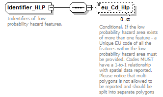 |
||
| namespace | http://water.eionet.europa.eu/schemas/dir200760ec | ||
| children | eu_Cd_Hlp | ||
| used by |
|
||
| annotation |
|
||
| source | <xs:complexType name="Identifier_HLP"> <xs:annotation> <xs:documentation>Indentifiers of low probability hazard features.</xs:documentation> </xs:annotation> <xs:sequence> <xs:element name="eu_Cd_Hlp" type="fd:FeatureUniqueCodeType" minOccurs="0" maxOccurs="unbounded"> <xs:annotation> <xs:documentation>Conditional. If the low probability hazard area exists of more than one feature - a Unique EU code of all the features within the low probability hazard area must be provided. Codes MUST have a 1-to-1 relationship with spatial data reported. Please notice that multi polygons is not allowed to be reported and should be split into separate polygons </xs:documentation> </xs:annotation> </xs:element> </xs:sequence> </xs:complexType> |
element Identifier_HLP/eu_Cd_Hlp
| diagram | 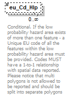 |
||||||||||||
| namespace | http://water.eionet.europa.eu/schemas/dir200760ec | ||||||||||||
| type | FeatureUniqueCodeType | ||||||||||||
| properties |
|
||||||||||||
| facets |
|
||||||||||||
| annotation |
|
||||||||||||
| source | <xs:element name="eu_Cd_Hlp" type="fd:FeatureUniqueCodeType" minOccurs="0" maxOccurs="unbounded"> <xs:annotation> <xs:documentation>Conditional. If the low probability hazard area exists of more than one feature - a Unique EU code of all the features within the low probability hazard area must be provided. Codes MUST have a 1-to-1 relationship with spatial data reported. Please notice that multi polygons is not allowed to be reported and should be split into separate polygons </xs:documentation> </xs:annotation> </xs:element> |
complexType Identifier_HMP
| diagram | 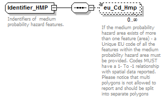 |
||
| namespace | http://water.eionet.europa.eu/schemas/dir200760ec | ||
| children | eu_Cd_Hmp | ||
| used by |
|
||
| annotation |
|
||
| source | <xs:complexType name="Identifier_HMP"> <xs:annotation> <xs:documentation>Indentifiers of medium probability hazard features.</xs:documentation> </xs:annotation> <xs:sequence> <xs:element name="eu_Cd_Hmp" type="fd:FeatureUniqueCodeType" minOccurs="0" maxOccurs="unbounded"> <xs:annotation> <xs:documentation>If the medium probability hazard area exists of more than one feature (area) - a Unique EU code of all the features within the medium probability hazard area must be provided. Codes MUST have a 1- To -1 relationship with spatial data reported. Please notice that multi polygons is not allowed to report and should be split into separate polygons</xs:documentation> </xs:annotation> </xs:element> </xs:sequence> </xs:complexType> |
element Identifier_HMP/eu_Cd_Hmp
| diagram | 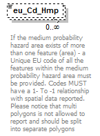 |
||||||||||||
| namespace | http://water.eionet.europa.eu/schemas/dir200760ec | ||||||||||||
| type | FeatureUniqueCodeType | ||||||||||||
| properties |
|
||||||||||||
| facets |
|
||||||||||||
| annotation |
|
||||||||||||
| source | <xs:element name="eu_Cd_Hmp" type="fd:FeatureUniqueCodeType" minOccurs="0" maxOccurs="unbounded"> <xs:annotation> <xs:documentation>If the medium probability hazard area exists of more than one feature (area) - a Unique EU code of all the features within the medium probability hazard area must be provided. Codes MUST have a 1- To -1 relationship with spatial data reported. Please notice that multi polygons is not allowed to report and should be split into separate polygons</xs:documentation> </xs:annotation> </xs:element> |
complexType IEDInstallations
| diagram | 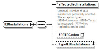 |
||
| namespace | http://water.eionet.europa.eu/schemas/dir200760ec | ||
| children | affectedIedInstallations EPRTRCodes TypeIEDInstallations | ||
| used by |
|
||
| source | <xs:complexType name="IEDInstallations"> <xs:sequence> <xs:element name="affectedIedInstallations" type="fd:NumberNonNegativeIntegerType"> <xs:annotation> <xs:documentation>Optional. Number of IED installations potentially affected. The exception types -9999=Unknown, -8888=Yet to be measured, -7777=Not Applicable can be used.</xs:documentation> </xs:annotation> </xs:element> <xs:element name="EPRTRCodes" type="EPRTRCodes" minOccurs="0"/> <xs:element name="TypeIEDInstallations" type="TypeIEDInstallations" minOccurs="0"/> </xs:sequence> </xs:complexType> |
element IEDInstallations/affectedIedInstallations
| diagram | 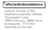 |
||||
| namespace | http://water.eionet.europa.eu/schemas/dir200760ec | ||||
| type | NumberNonNegativeIntegerType | ||||
| properties |
|
||||
| annotation |
|
||||
| source | <xs:element name="affectedIedInstallations" type="fd:NumberNonNegativeIntegerType"> <xs:annotation> <xs:documentation>Optional. Number of IED installations potentially affected. The exception types -9999=Unknown, -8888=Yet to be measured, -7777=Not Applicable can be used.</xs:documentation> </xs:annotation> </xs:element> |
element IEDInstallations/EPRTRCodes
| diagram | 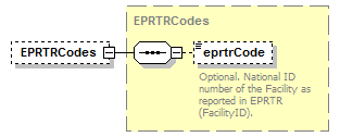 |
||||||||
| namespace | http://water.eionet.europa.eu/schemas/dir200760ec | ||||||||
| type | EPRTRCodes | ||||||||
| properties |
|
||||||||
| children | eprtrCode | ||||||||
| source | <xs:element name="EPRTRCodes" type="EPRTRCodes" minOccurs="0"/> |
element IEDInstallations/TypeIEDInstallations
| diagram | 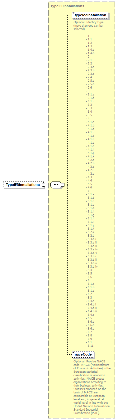 |
||||||||
| namespace | http://water.eionet.europa.eu/schemas/dir200760ec | ||||||||
| type | TypeIEDInstallations | ||||||||
| properties |
|
||||||||
| children | typeIedInstallation naceCode | ||||||||
| source | <xs:element name="TypeIEDInstallations" type="TypeIEDInstallations" minOccurs="0"/> |
complexType InhabitantsAffected
| diagram | 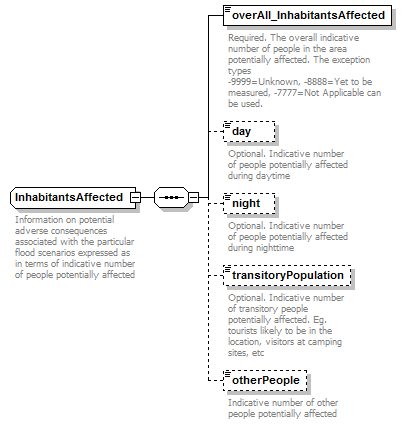 |
||
| namespace | http://water.eionet.europa.eu/schemas/dir200760ec | ||
| children | overAll_InhabitantsAffected day night transitoryPopulation otherPeople | ||
| used by |
|
||
| annotation |
|
||
| source | <xs:complexType name="InhabitantsAffected"> <xs:annotation> <xs:documentation>Information on potential adverse consequences associated with the particular flood scenarios expressed as in terms of indicative number of people potentially affected</xs:documentation> </xs:annotation> <xs:sequence> <xs:element name="overAll_InhabitantsAffected" type="fd:NumberNonNegativeIntegerType"> <xs:annotation> <xs:documentation>Required. The overall indicative number of people in the area potentially affected. The exception types -9999=Unknown, -8888=Yet to be measured, -7777=Not Applicable can be used.</xs:documentation> </xs:annotation> </xs:element> <xs:element name="day" type="fd:NumberNonNegativeIntegerType" minOccurs="0"> <xs:annotation> <xs:documentation>Optional. Indicative number of people potentially affected during daytime</xs:documentation> </xs:annotation> </xs:element> <xs:element name="night" type="fd:NumberNonNegativeIntegerType" minOccurs="0"> <xs:annotation> <xs:documentation>Optional. Indicative number of people potentially affected during nighttime</xs:documentation> </xs:annotation> </xs:element> <xs:element name="transitoryPopulation" type="fd:NumberNonNegativeIntegerType" minOccurs="0"> <xs:annotation> <xs:documentation>Optional. Indicative number of transitory people potentially affected. Eg. tourists likely to be in the location, visitors at camping sites, etc</xs:documentation> </xs:annotation> </xs:element> <xs:element name="otherPeople" type="fd:NumberNonNegativeIntegerType" minOccurs="0"> <xs:annotation> <xs:documentation>Indicative number of other people potentially affected </xs:documentation> </xs:annotation> </xs:element> </xs:sequence> </xs:complexType> |
element InhabitantsAffected/overAll_InhabitantsAffected
| diagram | 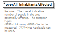 |
||||
| namespace | http://water.eionet.europa.eu/schemas/dir200760ec | ||||
| type | NumberNonNegativeIntegerType | ||||
| properties |
|
||||
| annotation |
|
||||
| source | <xs:element name="overAll_InhabitantsAffected" type="fd:NumberNonNegativeIntegerType"> <xs:annotation> <xs:documentation>Required. The overall indicative number of people in the area potentially affected. The exception types -9999=Unknown, -8888=Yet to be measured, -7777=Not Applicable can be used.</xs:documentation> </xs:annotation> </xs:element> |
element InhabitantsAffected/day
| diagram |  |
||||||||
| namespace | http://water.eionet.europa.eu/schemas/dir200760ec | ||||||||
| type | NumberNonNegativeIntegerType | ||||||||
| properties |
|
||||||||
| annotation |
|
||||||||
| source | <xs:element name="day" type="fd:NumberNonNegativeIntegerType" minOccurs="0"> <xs:annotation> <xs:documentation>Optional. Indicative number of people potentially affected during daytime</xs:documentation> </xs:annotation> </xs:element> |
element InhabitantsAffected/night
| diagram |  |
||||||||
| namespace | http://water.eionet.europa.eu/schemas/dir200760ec | ||||||||
| type | NumberNonNegativeIntegerType | ||||||||
| properties |
|
||||||||
| annotation |
|
||||||||
| source | <xs:element name="night" type="fd:NumberNonNegativeIntegerType" minOccurs="0"> <xs:annotation> <xs:documentation>Optional. Indicative number of people potentially affected during nighttime</xs:documentation> </xs:annotation> </xs:element> |
element InhabitantsAffected/transitoryPopulation
| diagram |  |
||||||||
| namespace | http://water.eionet.europa.eu/schemas/dir200760ec | ||||||||
| type | NumberNonNegativeIntegerType | ||||||||
| properties |
|
||||||||
| annotation |
|
||||||||
| source | <xs:element name="transitoryPopulation" type="fd:NumberNonNegativeIntegerType" minOccurs="0"> <xs:annotation> <xs:documentation>Optional. Indicative number of transitory people potentially affected. Eg. tourists likely to be in the location, visitors at camping sites, etc</xs:documentation> </xs:annotation> </xs:element> |
element InhabitantsAffected/otherPeople
| diagram |  |
||||||||
| namespace | http://water.eionet.europa.eu/schemas/dir200760ec | ||||||||
| type | NumberNonNegativeIntegerType | ||||||||
| properties |
|
||||||||
| annotation |
|
||||||||
| source | <xs:element name="otherPeople" type="fd:NumberNonNegativeIntegerType" minOccurs="0"> <xs:annotation> <xs:documentation>Indicative number of other people potentially affected </xs:documentation> </xs:annotation> </xs:element> |
complexType Low
| diagram | 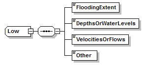 |
||
| namespace | http://water.eionet.europa.eu/schemas/dir200760ec | ||
| children | FloodingExtent DepthsOrWaterLevels VelocitiesOrFlows Other | ||
| used by |
|
||
| source | <xs:complexType name="Low"> <xs:sequence> <xs:element name="FloodingExtent" type="xs:string"/> <xs:element name="DepthsOrWaterLevels" type="xs:string"/> <xs:element name="VelocitiesOrFlows" type="xs:string"/> <xs:element name="Other" type="xs:string"/> </xs:sequence> </xs:complexType> |
element Low/FloodingExtent
| diagram | |||||
| namespace | http://water.eionet.europa.eu/schemas/dir200760ec | ||||
| type | xs:string | ||||
| properties |
|
||||
| source | <xs:element name="FloodingExtent" type="xs:string"/> |
element Low/DepthsOrWaterLevels
| diagram | |||||
| namespace | http://water.eionet.europa.eu/schemas/dir200760ec | ||||
| type | xs:string | ||||
| properties |
|
||||
| source | <xs:element name="DepthsOrWaterLevels" type="xs:string"/> |
element Low/VelocitiesOrFlows
| diagram | |||||
| namespace | http://water.eionet.europa.eu/schemas/dir200760ec | ||||
| type | xs:string | ||||
| properties |
|
||||
| source | <xs:element name="VelocitiesOrFlows" type="xs:string"/> |
element Low/Other
| diagram | |||||
| namespace | http://water.eionet.europa.eu/schemas/dir200760ec | ||||
| type | xs:string | ||||
| properties |
|
||||
| source | <xs:element name="Other" type="xs:string"/> |
complexType LowProbability
| diagram | 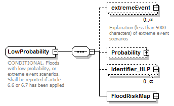 |
||
| namespace | http://water.eionet.europa.eu/schemas/dir200760ec | ||
| children | extremeEvent Probability Identifier_HLP FloodRiskMap | ||
| used by |
|
||
| annotation |
|
||
| source | <xs:complexType name="LowProbability"> <xs:annotation> <xs:documentation>CONDITIONAL. Floods with low probability, or extreme event scenarios. Shall be reported if article 6.6 or 6.7 has been applied</xs:documentation> </xs:annotation> <xs:sequence> <xs:element name="extremeEvent" type="fd:ReferenceType" minOccurs="0" maxOccurs="unbounded"> <xs:annotation> <xs:documentation>Explanation (less than 5000 characters) of extreme event scenarios</xs:documentation> </xs:annotation> </xs:element> <xs:element name="Probability" type="Probability" minOccurs="0"/> <xs:element name="Identifier_HLP" type="Identifier_HLP" minOccurs="0" maxOccurs="unbounded"/> <xs:element name="FloodRiskMap" type="FloodRiskMap"/> </xs:sequence> </xs:complexType> |
element LowProbability/extremeEvent
| diagram | 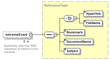 |
||||||||
| namespace | http://water.eionet.europa.eu/schemas/dir200760ec | ||||||||
| type | ReferenceType | ||||||||
| properties |
|
||||||||
| children | Hyperlink FileName Bookmark DocumentName Subject | ||||||||
| annotation |
|
||||||||
| source | <xs:element name="extremeEvent" type="fd:ReferenceType" minOccurs="0" maxOccurs="unbounded"> <xs:annotation> <xs:documentation>Explanation (less than 5000 characters) of extreme event scenarios</xs:documentation> </xs:annotation> </xs:element> |
element LowProbability/Probability
| diagram | 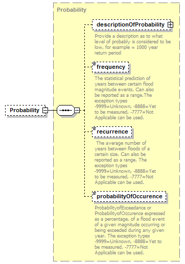 |
||||||||
| namespace | http://water.eionet.europa.eu/schemas/dir200760ec | ||||||||
| type | Probability | ||||||||
| properties |
|
||||||||
| children | descriptionOfProbability frequency recurrence probabilityOfOccurence | ||||||||
| source | <xs:element name="Probability" type="Probability" minOccurs="0"/> |
element LowProbability/Identifier_HLP
| diagram | 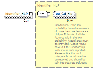 |
||||||||
| namespace | http://water.eionet.europa.eu/schemas/dir200760ec | ||||||||
| type | Identifier_HLP | ||||||||
| properties |
|
||||||||
| children | eu_Cd_Hlp | ||||||||
| source | <xs:element name="Identifier_HLP" type="Identifier_HLP" minOccurs="0" maxOccurs="unbounded"/> |
element LowProbability/FloodRiskMap
| diagram | 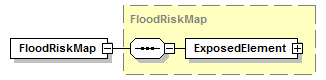 |
||||
| namespace | http://water.eionet.europa.eu/schemas/dir200760ec | ||||
| type | FloodRiskMap | ||||
| properties |
|
||||
| children | ExposedElement | ||||
| source | <xs:element name="FloodRiskMap" type="FloodRiskMap"/> |
complexType Medium
| diagram | 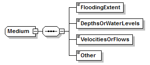 |
||
| namespace | http://water.eionet.europa.eu/schemas/dir200760ec | ||
| children | FloodingExtent DepthsOrWaterLevels VelocitiesOrFlows Other | ||
| used by |
|
||
| source | <xs:complexType name="Medium"> <xs:sequence> <xs:element name="FloodingExtent" type="xs:string"/> <xs:element name="DepthsOrWaterLevels" type="xs:string"/> <xs:element name="VelocitiesOrFlows" type="xs:string"/> <xs:element name="Other" type="xs:string"/> </xs:sequence> </xs:complexType> |
element Medium/FloodingExtent
| diagram | |||||
| namespace | http://water.eionet.europa.eu/schemas/dir200760ec | ||||
| type | xs:string | ||||
| properties |
|
||||
| source | <xs:element name="FloodingExtent" type="xs:string"/> |
element Medium/DepthsOrWaterLevels
| diagram | |||||
| namespace | http://water.eionet.europa.eu/schemas/dir200760ec | ||||
| type | xs:string | ||||
| properties |
|
||||
| source | <xs:element name="DepthsOrWaterLevels" type="xs:string"/> |
element Medium/VelocitiesOrFlows
| diagram | |||||
| namespace | http://water.eionet.europa.eu/schemas/dir200760ec | ||||
| type | xs:string | ||||
| properties |
|
||||
| source | <xs:element name="VelocitiesOrFlows" type="xs:string"/> |
element Medium/Other
| diagram | |||||
| namespace | http://water.eionet.europa.eu/schemas/dir200760ec | ||||
| type | xs:string | ||||
| properties |
|
||||
| source | <xs:element name="Other" type="xs:string"/> |
complexType MediumProbability
| diagram | 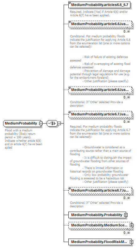 |
||
| namespace | http://water.eionet.europa.eu/schemas/dir200760ec | ||
| children | MediumProbability.articles6.6_6.7 MediumProbability.article6.6Justification MediumProbability.article6.6JustificationOther MediumProbability.article6.7Justification MediumProbability.articles6.7JustificationOther MediumProbability.Probability MediumProbability.MediumScenario MediumProbability.FloodRiskMap | ||
| used by |
|
||
| annotation |
|
||
| source | <xs:complexType name="MediumProbability"> <xs:annotation> <xs:documentation>Flood with a medium probability (likely return period = 100 years). Indicate whether article 6(6) and or article 6(7) have been aplied</xs:documentation> </xs:annotation> <xs:choice> <xs:element name="MediumProbability.articles6.6_6.7" type="fd:YesNoCode"> <xs:annotation> <xs:documentation>Required. Indicate (Yes) if Article 6(6) and/or Article 6(7) have been applied.</xs:documentation> </xs:annotation> </xs:element> <xs:element name="MediumProbability.article6.6Justification" type="fd:Article_6.6_Justification_Enum" minOccurs="0" maxOccurs="unbounded"> <xs:annotation> <xs:documentation>Conditional. For medium probability floods indicate the justification for applying Article 6.6 from the enumeration list (one or more options can be selected): - Risk of failure of existing defences assessed - Risk of overtopping of existing flood defences assessed - Prevention of damage and damage potential through legal regulations for use (e.g. for the embankment foreland) - Other justification (please specify)</xs:documentation> </xs:annotation> </xs:element> <xs:element name="MediumProbability.article6.6JustificationOther" type="fd:String1000Type" minOccurs="0" maxOccurs="unbounded"> <xs:annotation> <xs:documentation>Conditional. If ‘Other’ selected Provide a description</xs:documentation> </xs:annotation> </xs:element> <xs:element name="MediumProbability.article6.7Justification" type="fd:Article_6.7_Justification_Enum" minOccurs="0" maxOccurs="unbounded"> <xs:annotation> <xs:documentation>Required. For medium probability floods indicate the justification for applying Article 6.7 from the enumeration list (one or more options can be selected): - Groundwater is considered as a contributing source rather than a main source of flooding - It is difficult to distinguish the impact of groundwater flooding from other sources of flooding - There is limited information or historical records on groundwater flooding - Only low probability groundwater flooding is assessed to be a hazardous risk - Other justification (please specify)</xs:documentation> </xs:annotation> </xs:element> <xs:element name="MediumProbability.articles6.7JustificationOther" type="fd:String1000Type" minOccurs="0" maxOccurs="unbounded"> <xs:annotation> <xs:documentation>Conditional. If ‘Other’ selected Provide a description</xs:documentation> </xs:annotation> </xs:element> <xs:element name="MediumProbability.Probability" type="Probability"/> <xs:element name="MediumProbability.MediumScenario" type="MediumScenario" minOccurs="0" maxOccurs="unbounded"/> <xs:element name="MediumProbability.FloodRiskMap" type="FloodRiskMap"/> </xs:choice> </xs:complexType> |
element MediumProbability/MediumProbability.articles6.6_6.7
| diagram | 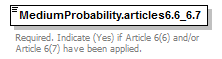 |
||||||||||||
| namespace | http://water.eionet.europa.eu/schemas/dir200760ec | ||||||||||||
| type | YesNoCode | ||||||||||||
| properties |
|
||||||||||||
| facets |
|
||||||||||||
| annotation |
|
||||||||||||
| source | <xs:element name="MediumProbability.articles6.6_6.7" type="fd:YesNoCode"> <xs:annotation> <xs:documentation>Required. Indicate (Yes) if Article 6(6) and/or Article 6(7) have been applied.</xs:documentation> </xs:annotation> </xs:element> |
element MediumProbability/MediumProbability.article6.6Justification
| diagram | 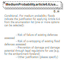 |
|||||||||||||||
| namespace | http://water.eionet.europa.eu/schemas/dir200760ec | |||||||||||||||
| type | Article_6.6_Justification_Enum | |||||||||||||||
| properties |
|
|||||||||||||||
| facets |
|
|||||||||||||||
| annotation |
|
|||||||||||||||
| source | <xs:element name="MediumProbability.article6.6Justification" type="fd:Article_6.6_Justification_Enum" minOccurs="0" maxOccurs="unbounded"> <xs:annotation> <xs:documentation>Conditional. For medium probability floods indicate the justification for applying Article 6.6 from the enumeration list (one or more options can be selected): - Risk of failure of existing defences assessed - Risk of overtopping of existing flood defences assessed - Prevention of damage and damage potential through legal regulations for use (e.g. for the embankment foreland) - Other justification (please specify)</xs:documentation> </xs:annotation> </xs:element> |
element MediumProbability/MediumProbability.article6.6JustificationOther
| diagram |  |
|||||||||
| namespace | http://water.eionet.europa.eu/schemas/dir200760ec | |||||||||
| type | String1000Type | |||||||||
| properties |
|
|||||||||
| facets |
|
|||||||||
| annotation |
|
|||||||||
| source | <xs:element name="MediumProbability.article6.6JustificationOther" type="fd:String1000Type" minOccurs="0" maxOccurs="unbounded"> <xs:annotation> <xs:documentation>Conditional. If ‘Other’ selected Provide a description</xs:documentation> </xs:annotation> </xs:element> |
element MediumProbability/MediumProbability.article6.7Justification
| diagram | 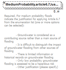 |
||||||||||||||||||
| namespace | http://water.eionet.europa.eu/schemas/dir200760ec | ||||||||||||||||||
| type | Article_6.7_Justification_Enum | ||||||||||||||||||
| properties |
|
||||||||||||||||||
| facets |
|
||||||||||||||||||
| annotation |
|
||||||||||||||||||
| source | <xs:element name="MediumProbability.article6.7Justification" type="fd:Article_6.7_Justification_Enum" minOccurs="0" maxOccurs="unbounded"> <xs:annotation> <xs:documentation>Required. For medium probability floods indicate the justification for applying Article 6.7 from the enumeration list (one or more options can be selected): - Groundwater is considered as a contributing source rather than a main source of flooding - It is difficult to distinguish the impact of groundwater flooding from other sources of flooding - There is limited information or historical records on groundwater flooding - Only low probability groundwater flooding is assessed to be a hazardous risk - Other justification (please specify)</xs:documentation> </xs:annotation> </xs:element> |
element MediumProbability/MediumProbability.articles6.7JustificationOther
| diagram | 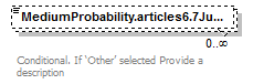 |
|||||||||
| namespace | http://water.eionet.europa.eu/schemas/dir200760ec | |||||||||
| type | String1000Type | |||||||||
| properties |
|
|||||||||
| facets |
|
|||||||||
| annotation |
|
|||||||||
| source | <xs:element name="MediumProbability.articles6.7JustificationOther" type="fd:String1000Type" minOccurs="0" maxOccurs="unbounded"> <xs:annotation> <xs:documentation>Conditional. If ‘Other’ selected Provide a description</xs:documentation> </xs:annotation> </xs:element> |
element MediumProbability/MediumProbability.Probability
| diagram | 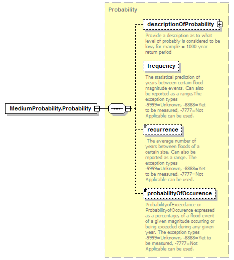 |
||||
| namespace | http://water.eionet.europa.eu/schemas/dir200760ec | ||||
| type | Probability | ||||
| properties |
|
||||
| children | descriptionOfProbability frequency recurrence probabilityOfOccurence | ||||
| source | <xs:element name="MediumProbability.Probability" type="Probability"/> |
element MediumProbability/MediumProbability.MediumScenario
| diagram |  |
||||||||
| namespace | http://water.eionet.europa.eu/schemas/dir200760ec | ||||||||
| type | MediumScenario | ||||||||
| properties |
|
||||||||
| children | Identifier_HMP | ||||||||
| source | <xs:element name="MediumProbability.MediumScenario" type="MediumScenario" minOccurs="0" maxOccurs="unbounded"/> |
element MediumProbability/MediumProbability.FloodRiskMap
| diagram | 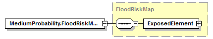 |
||||
| namespace | http://water.eionet.europa.eu/schemas/dir200760ec | ||||
| type | FloodRiskMap | ||||
| properties |
|
||||
| children | ExposedElement | ||||
| source | <xs:element name="MediumProbability.FloodRiskMap" type="FloodRiskMap"/> |
complexType MediumScenario
| diagram | 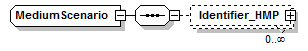 |
||
| namespace | http://water.eionet.europa.eu/schemas/dir200760ec | ||
| children | Identifier_HMP | ||
| used by |
|
||
| source | <xs:complexType name="MediumScenario"> <xs:sequence> <xs:element name="Identifier_HMP" type="Identifier_HMP" minOccurs="0" maxOccurs="unbounded"/> </xs:sequence> </xs:complexType> |
element MediumScenario/Identifier_HMP
| diagram | 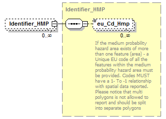 |
||||||||
| namespace | http://water.eionet.europa.eu/schemas/dir200760ec | ||||||||
| type | Identifier_HMP | ||||||||
| properties |
|
||||||||
| children | eu_Cd_Hmp | ||||||||
| source | <xs:element name="Identifier_HMP" type="Identifier_HMP" minOccurs="0" maxOccurs="unbounded"/> |
complexType NACECodes
| diagram | 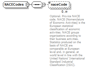 |
||
| namespace | http://water.eionet.europa.eu/schemas/dir200760ec | ||
| children | naceCode | ||
| used by |
|
||
| source | <xs:complexType name="NACECodes"> <xs:sequence> <xs:element name="naceCode" type="fd:String100Type" minOccurs="0" maxOccurs="unbounded"> <xs:annotation> <xs:documentation>Optional. Provice NACE code. NACE (Nomenclature of Economic Activities) is the European statistical classification of economic activities. NACE groups organizations according to their business activities. Statistics produced on the basis of NACE are comparable at European level and, in general, at world level in line with the United Nations' International Standard Industrial Classification (ISIC).</xs:documentation> </xs:annotation> </xs:element> </xs:sequence> </xs:complexType> |
element NACECodes/naceCode
| diagram | 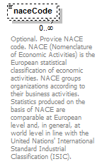 |
|||||||||
| namespace | http://water.eionet.europa.eu/schemas/dir200760ec | |||||||||
| type | String100Type | |||||||||
| properties |
|
|||||||||
| facets |
|
|||||||||
| annotation |
|
|||||||||
| source | <xs:element name="naceCode" type="fd:String100Type" minOccurs="0" maxOccurs="unbounded"> <xs:annotation> <xs:documentation>Optional. Provice NACE code. NACE (Nomenclature of Economic Activities) is the European statistical classification of economic activities. NACE groups organizations according to their business activities. Statistics produced on the basis of NACE are comparable at European level and, in general, at world level in line with the United Nations' International Standard Industrial Classification (ISIC).</xs:documentation> </xs:annotation> </xs:element> |
complexType OtherConsequences
| diagram | 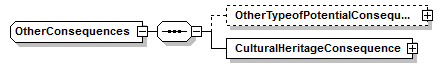 |
||
| namespace | http://water.eionet.europa.eu/schemas/dir200760ec | ||
| children | OtherTypeofPotentialConsequences CulturalHeritageConsequence | ||
| used by |
|
||
| source | <xs:complexType name="OtherConsequences"> <xs:sequence> <xs:element name="OtherTypeofPotentialConsequences" type="OtherTypeofPotentialConsequences" minOccurs="0"/> <xs:element name="CulturalHeritageConsequence" type="CulturalHeritageConsequence"/> </xs:sequence> </xs:complexType> |
element OtherConsequences/OtherTypeofPotentialConsequences
| diagram | 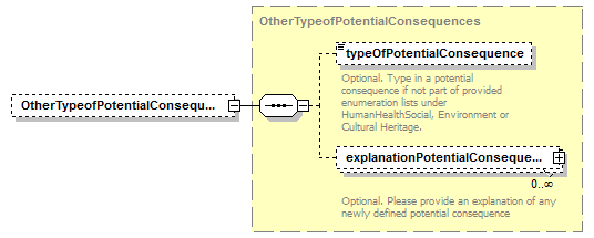 |
||||||||
| namespace | http://water.eionet.europa.eu/schemas/dir200760ec | ||||||||
| type | OtherTypeofPotentialConsequences | ||||||||
| properties |
|
||||||||
| children | typeOfPotentialConsequence explanationPotentialConsequence | ||||||||
| source | <xs:element name="OtherTypeofPotentialConsequences" type="OtherTypeofPotentialConsequences" minOccurs="0"/> |
element OtherConsequences/CulturalHeritageConsequence
| diagram | 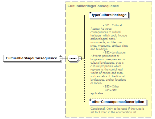 |
||||
| namespace | http://water.eionet.europa.eu/schemas/dir200760ec | ||||
| type | CulturalHeritageConsequence | ||||
| properties |
|
||||
| children | typeCulturalHeritage otherConsequenceDescription | ||||
| source | <xs:element name="CulturalHeritageConsequence" type="CulturalHeritageConsequence"/> |
complexType OtherSource
| diagram | 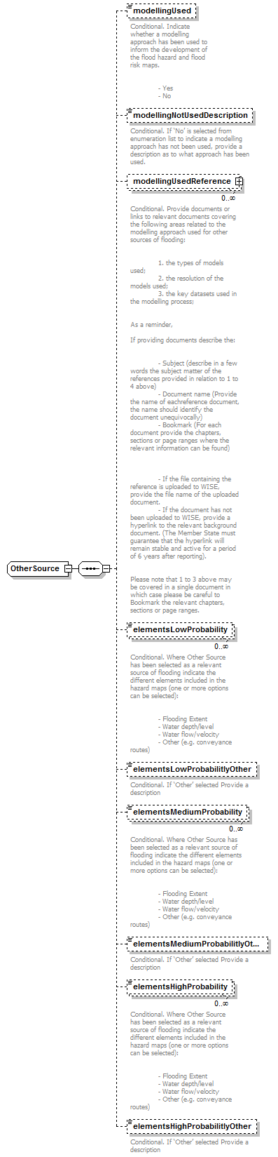 |
||
| namespace | http://water.eionet.europa.eu/schemas/dir200760ec | ||
| children | modellingUsed modellingNotUsedDescription modellingUsedReference elementsLowProbability elementsLowProbabilitlyOther elementsMediumProbability elementsMediumProbabilitlyOther elementsHighProbability elementsHighProbabilitlyOther | ||
| used by |
|
||
| source | <xs:complexType name="OtherSource"> <xs:sequence> <xs:element name="modellingUsed" type="fd:YesNoCode" minOccurs="0"> <xs:annotation> <xs:documentation>Conditional. Indicate whether a modelling approach has been used to inform the development of the flood hazard and flood risk maps. - Yes - No</xs:documentation> </xs:annotation> </xs:element> <xs:element name="modellingNotUsedDescription" type="fd:String1000Type" minOccurs="0"> <xs:annotation> <xs:documentation>Conditional. If ‘No’ is selected from enumeration list to indicate a modelling approach has not been used, provide a description as to what approach has been used.</xs:documentation> </xs:annotation> </xs:element> <xs:element name="modellingUsedReference" type="fd:ReferenceType" minOccurs="0" maxOccurs="unbounded"> <xs:annotation> <xs:documentation>Conditional. Provide documents or links to relevant documents covering the following areas related to the modelling approach used for other sources of flooding: 1. the types of models used; 2. the resolution of the models used; 3. the key datasets used in the modelling process; As a reminder, If providing documents describe the: - Subject (describe in a few words the subject matter of the references provided in relation to 1 to 4 above) - Document name (Provide the name of eachreference document, the name should identify the document unequivocally) - Bookmark (For each document provide the chapters, sections or page ranges where the relevant information can be found) - If the file containing the reference is uploaded to WISE, provide the file name of the uploaded document. - If the document has not been uploaded to WISE, provide a hyperlink to the relevant background document. (The Member State must guarantee that the hyperlink will remain stable and active for a period of 6 years after reporting). Please note that 1 to 3 above may be covered in a single document in which case please be careful to Bookmark the relevant chapters, sections or page ranges. </xs:documentation> </xs:annotation> </xs:element> <xs:element name="elementsLowProbability" type="fd:ElementsProbability_Enum" minOccurs="0" maxOccurs="unbounded"> <xs:annotation> <xs:documentation>Conditional. Where Other Source has been selected as a relevant source of flooding indicate the different elements included in the hazard maps (one or more options can be selected): - Flooding Extent - Water depth/level - Water flow/velocity - Other (e.g. conveyance routes)</xs:documentation> </xs:annotation> </xs:element> <xs:element name="elementsLowProbabilitlyOther" type="fd:String1000Type" minOccurs="0"> <xs:annotation> <xs:documentation>Conditional. If ‘Other’ selected Provide a description</xs:documentation> </xs:annotation> </xs:element> <xs:element name="elementsMediumProbability" type="fd:ElementsProbability_Enum" minOccurs="0" maxOccurs="unbounded"> <xs:annotation> <xs:documentation>Conditional. Where Other Source has been selected as a relevant source of flooding indicate the different elements included in the hazard maps (one or more options can be selected): - Flooding Extent - Water depth/level - Water flow/velocity - Other (e.g. conveyance routes)</xs:documentation> </xs:annotation> </xs:element> <xs:element name="elementsMediumProbabilitlyOther" type="fd:String1000Type" minOccurs="0"> <xs:annotation> <xs:documentation>Conditional. If ‘Other’ selected Provide a description</xs:documentation> </xs:annotation> </xs:element> <xs:element name="elementsHighProbability" type="fd:ElementsProbability_Enum" minOccurs="0" maxOccurs="unbounded"> <xs:annotation> <xs:documentation>Conditional. Where Other Source has been selected as a relevant source of flooding indicate the different elements included in the hazard maps (one or more options can be selected): - Flooding Extent - Water depth/level - Water flow/velocity - Other (e.g. conveyance routes)</xs:documentation> </xs:annotation> </xs:element> <xs:element name="elementsHighProbabilitlyOther" type="fd:String1000Type" minOccurs="0"> <xs:annotation> <xs:documentation>Conditional. If ‘Other’ selected Provide a description</xs:documentation> </xs:annotation> </xs:element> </xs:sequence> </xs:complexType> |
element OtherSource/modellingUsed
| diagram |  |
||||||||||||
| namespace | http://water.eionet.europa.eu/schemas/dir200760ec | ||||||||||||
| type | YesNoCode | ||||||||||||
| properties |
|
||||||||||||
| facets |
|
||||||||||||
| annotation |
|
||||||||||||
| source | <xs:element name="modellingUsed" type="fd:YesNoCode" minOccurs="0"> <xs:annotation> <xs:documentation>Conditional. Indicate whether a modelling approach has been used to inform the development of the flood hazard and flood risk maps. - Yes - No</xs:documentation> </xs:annotation> </xs:element> |
element OtherSource/modellingNotUsedDescription
| diagram | 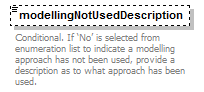 |
|||||||||
| namespace | http://water.eionet.europa.eu/schemas/dir200760ec | |||||||||
| type | String1000Type | |||||||||
| properties |
|
|||||||||
| facets |
|
|||||||||
| annotation |
|
|||||||||
| source | <xs:element name="modellingNotUsedDescription" type="fd:String1000Type" minOccurs="0"> <xs:annotation> <xs:documentation>Conditional. If ‘No’ is selected from enumeration list to indicate a modelling approach has not been used, provide a description as to what approach has been used.</xs:documentation> </xs:annotation> </xs:element> |
element OtherSource/modellingUsedReference
| diagram |  |
||||||||
| namespace | http://water.eionet.europa.eu/schemas/dir200760ec | ||||||||
| type | ReferenceType | ||||||||
| properties |
|
||||||||
| children | Hyperlink FileName Bookmark DocumentName Subject | ||||||||
| annotation |
|
||||||||
| source | <xs:element name="modellingUsedReference" type="fd:ReferenceType" minOccurs="0" maxOccurs="unbounded"> <xs:annotation> <xs:documentation>Conditional. Provide documents or links to relevant documents covering the following areas related to the modelling approach used for other sources of flooding: 1. the types of models used; 2. the resolution of the models used; 3. the key datasets used in the modelling process; As a reminder, If providing documents describe the: - Subject (describe in a few words the subject matter of the references provided in relation to 1 to 4 above) - Document name (Provide the name of eachreference document, the name should identify the document unequivocally) - Bookmark (For each document provide the chapters, sections or page ranges where the relevant information can be found) - If the file containing the reference is uploaded to WISE, provide the file name of the uploaded document. - If the document has not been uploaded to WISE, provide a hyperlink to the relevant background document. (The Member State must guarantee that the hyperlink will remain stable and active for a period of 6 years after reporting). Please note that 1 to 3 above may be covered in a single document in which case please be careful to Bookmark the relevant chapters, sections or page ranges. </xs:documentation> </xs:annotation> </xs:element> |
element OtherSource/elementsLowProbability
| diagram | 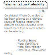 |
|||||||||||||||||||||
| namespace | http://water.eionet.europa.eu/schemas/dir200760ec | |||||||||||||||||||||
| type | ElementsProbability_Enum | |||||||||||||||||||||
| properties |
|
|||||||||||||||||||||
| facets |
|
|||||||||||||||||||||
| annotation |
|
|||||||||||||||||||||
| source | <xs:element name="elementsLowProbability" type="fd:ElementsProbability_Enum" minOccurs="0" maxOccurs="unbounded"> <xs:annotation> <xs:documentation>Conditional. Where Other Source has been selected as a relevant source of flooding indicate the different elements included in the hazard maps (one or more options can be selected): - Flooding Extent - Water depth/level - Water flow/velocity - Other (e.g. conveyance routes)</xs:documentation> </xs:annotation> </xs:element> |
element OtherSource/elementsLowProbabilitlyOther
| diagram | 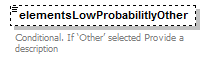 |
|||||||||
| namespace | http://water.eionet.europa.eu/schemas/dir200760ec | |||||||||
| type | String1000Type | |||||||||
| properties |
|
|||||||||
| facets |
|
|||||||||
| annotation |
|
|||||||||
| source | <xs:element name="elementsLowProbabilitlyOther" type="fd:String1000Type" minOccurs="0"> <xs:annotation> <xs:documentation>Conditional. If ‘Other’ selected Provide a description</xs:documentation> </xs:annotation> </xs:element> |
element OtherSource/elementsMediumProbability
| diagram | 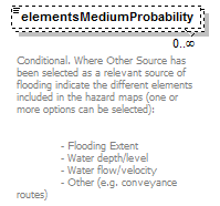 |
|||||||||||||||||||||
| namespace | http://water.eionet.europa.eu/schemas/dir200760ec | |||||||||||||||||||||
| type | ElementsProbability_Enum | |||||||||||||||||||||
| properties |
|
|||||||||||||||||||||
| facets |
|
|||||||||||||||||||||
| annotation |
|
|||||||||||||||||||||
| source | <xs:element name="elementsMediumProbability" type="fd:ElementsProbability_Enum" minOccurs="0" maxOccurs="unbounded"> <xs:annotation> <xs:documentation>Conditional. Where Other Source has been selected as a relevant source of flooding indicate the different elements included in the hazard maps (one or more options can be selected): - Flooding Extent - Water depth/level - Water flow/velocity - Other (e.g. conveyance routes)</xs:documentation> </xs:annotation> </xs:element> |
element OtherSource/elementsMediumProbabilitlyOther
| diagram |  |
|||||||||
| namespace | http://water.eionet.europa.eu/schemas/dir200760ec | |||||||||
| type | String1000Type | |||||||||
| properties |
|
|||||||||
| facets |
|
|||||||||
| annotation |
|
|||||||||
| source | <xs:element name="elementsMediumProbabilitlyOther" type="fd:String1000Type" minOccurs="0"> <xs:annotation> <xs:documentation>Conditional. If ‘Other’ selected Provide a description</xs:documentation> </xs:annotation> </xs:element> |
element OtherSource/elementsHighProbability
| diagram | 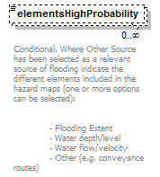 |
|||||||||||||||||||||
| namespace | http://water.eionet.europa.eu/schemas/dir200760ec | |||||||||||||||||||||
| type | ElementsProbability_Enum | |||||||||||||||||||||
| properties |
|
|||||||||||||||||||||
| facets |
|
|||||||||||||||||||||
| annotation |
|
|||||||||||||||||||||
| source | <xs:element name="elementsHighProbability" type="fd:ElementsProbability_Enum" minOccurs="0" maxOccurs="unbounded"> <xs:annotation> <xs:documentation>Conditional. Where Other Source has been selected as a relevant source of flooding indicate the different elements included in the hazard maps (one or more options can be selected): - Flooding Extent - Water depth/level - Water flow/velocity - Other (e.g. conveyance routes)</xs:documentation> </xs:annotation> </xs:element> |
element OtherSource/elementsHighProbabilitlyOther
| diagram |  |
|||||||||
| namespace | http://water.eionet.europa.eu/schemas/dir200760ec | |||||||||
| type | String1000Type | |||||||||
| properties |
|
|||||||||
| facets |
|
|||||||||
| annotation |
|
|||||||||
| source | <xs:element name="elementsHighProbabilitlyOther" type="fd:String1000Type" minOccurs="0"> <xs:annotation> <xs:documentation>Conditional. If ‘Other’ selected Provide a description</xs:documentation> </xs:annotation> </xs:element> |
complexType OtherTypeofPotentialConsequences
| diagram | 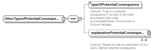 |
||
| namespace | http://water.eionet.europa.eu/schemas/dir200760ec | ||
| children | typeOfPotentialConsequence explanationPotentialConsequence | ||
| used by |
|
||
| source | <xs:complexType name="OtherTypeofPotentialConsequences"> <xs:sequence> <xs:element name="typeOfPotentialConsequence" type="fd:String250Type" minOccurs="0"> <xs:annotation> <xs:documentation>Optional. Type in a potential consequence if not part of provided enumeration lists under HumanHealthSocial, Environment or Cultural Heritage.</xs:documentation> </xs:annotation> </xs:element> <xs:element name="explanationPotentialConsequence" type="fd:ReferenceType" minOccurs="0" maxOccurs="unbounded"> <xs:annotation> <xs:documentation>Optional. Please provide an explanation of any newly defined potential consequence</xs:documentation> </xs:annotation> </xs:element> </xs:sequence> </xs:complexType> |
element OtherTypeofPotentialConsequences/typeOfPotentialConsequence
| diagram | 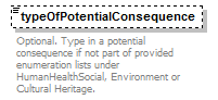 |
|||||||||
| namespace | http://water.eionet.europa.eu/schemas/dir200760ec | |||||||||
| type | String250Type | |||||||||
| properties |
|
|||||||||
| facets |
|
|||||||||
| annotation |
|
|||||||||
| source | <xs:element name="typeOfPotentialConsequence" type="fd:String250Type" minOccurs="0"> <xs:annotation> <xs:documentation>Optional. Type in a potential consequence if not part of provided enumeration lists under HumanHealthSocial, Environment or Cultural Heritage.</xs:documentation> </xs:annotation> </xs:element> |
element OtherTypeofPotentialConsequences/explanationPotentialConsequence
| diagram | 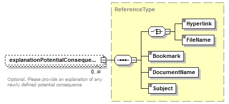 |
||||||||
| namespace | http://water.eionet.europa.eu/schemas/dir200760ec | ||||||||
| type | ReferenceType | ||||||||
| properties |
|
||||||||
| children | Hyperlink FileName Bookmark DocumentName Subject | ||||||||
| annotation |
|
||||||||
| source | <xs:element name="explanationPotentialConsequence" type="fd:ReferenceType" minOccurs="0" maxOccurs="unbounded"> <xs:annotation> <xs:documentation>Optional. Please provide an explanation of any newly defined potential consequence</xs:documentation> </xs:annotation> </xs:element> |
complexType Pluvial
| diagram | 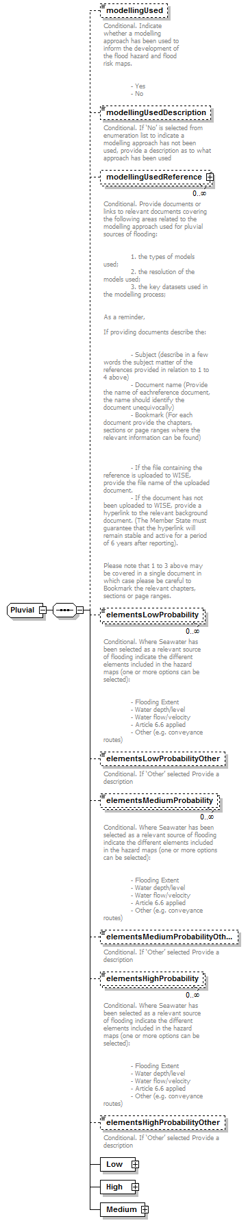 |
||
| namespace | http://water.eionet.europa.eu/schemas/dir200760ec | ||
| children | modellingUsed modellingUsedDescription modellingUsedReference elementsLowProbability elementsLowProbabilityOther elementsMediumProbability elementsMediumProbabilityOther elementsHighProbability elementsHighProbabilityOther Low High Medium | ||
| used by |
|
||
| source | <xs:complexType name="Pluvial"> <xs:sequence> <xs:element name="modellingUsed" type="fd:YesNoCode" minOccurs="0"> <xs:annotation> <xs:documentation>Conditional. Indicate whether a modelling approach has been used to inform the development of the flood hazard and flood risk maps. - Yes - No</xs:documentation> </xs:annotation> </xs:element> <xs:element name="modellingUsedDescription" type="fd:String1000Type" minOccurs="0"> <xs:annotation> <xs:documentation>Conditional. If ‘No’ is selected from enumeration list to indicate a modelling approach has not been used, provide a description as to what approach has been used</xs:documentation> </xs:annotation> </xs:element> <xs:element name="modellingUsedReference" type="fd:ReferenceType" minOccurs="0" maxOccurs="unbounded"> <xs:annotation> <xs:documentation>Conditional. Provide documents or links to relevant documents covering the following areas related to the modelling approach used for pluvial sources of flooding: 1. the types of models used; 2. the resolution of the models used; 3. the key datasets used in the modelling process; As a reminder, If providing documents describe the: - Subject (describe in a few words the subject matter of the references provided in relation to 1 to 4 above) - Document name (Provide the name of eachreference document, the name should identify the document unequivocally) - Bookmark (For each document provide the chapters, sections or page ranges where the relevant information can be found) - If the file containing the reference is uploaded to WISE, provide the file name of the uploaded document. - If the document has not been uploaded to WISE, provide a hyperlink to the relevant background document. (The Member State must guarantee that the hyperlink will remain stable and active for a period of 6 years after reporting). Please note that 1 to 3 above may be covered in a single document in which case please be careful to Bookmark the relevant chapters, sections or page ranges. </xs:documentation> </xs:annotation> </xs:element> <xs:element name="elementsLowProbability" type="fd:ElementsProbability_Enum" minOccurs="0" maxOccurs="unbounded"> <xs:annotation> <xs:documentation>Conditional. Where Seawater has been selected as a relevant source of flooding indicate the different elements included in the hazard maps (one or more options can be selected): - Flooding Extent - Water depth/level - Water flow/velocity - Article 6.6 applied - Other (e.g. conveyance routes)</xs:documentation> </xs:annotation> </xs:element> <xs:element name="elementsLowProbabilityOther" type="fd:String1000Type" minOccurs="0"> <xs:annotation> <xs:documentation>Conditional. If ‘Other’ selected Provide a description</xs:documentation> </xs:annotation> </xs:element> <xs:element name="elementsMediumProbability" type="fd:ElementsProbability_Enum" minOccurs="0" maxOccurs="unbounded"> <xs:annotation> <xs:documentation>Conditional. Where Seawater has been selected as a relevant source of flooding indicate the different elements included in the hazard maps (one or more options can be selected): - Flooding Extent - Water depth/level - Water flow/velocity - Article 6.6 applied - Other (e.g. conveyance routes)</xs:documentation> </xs:annotation> </xs:element> <xs:element name="elementsMediumProbabilityOther" type="fd:String1000Type" minOccurs="0"> <xs:annotation> <xs:documentation>Conditional. If ‘Other’ selected Provide a description</xs:documentation> </xs:annotation> </xs:element> <xs:element name="elementsHighProbability" type="fd:ElementsProbability_Enum" minOccurs="0" maxOccurs="unbounded"> <xs:annotation> <xs:documentation>Conditional. Where Seawater has been selected as a relevant source of flooding indicate the different elements included in the hazard maps (one or more options can be selected): - Flooding Extent - Water depth/level - Water flow/velocity - Article 6.6 applied - Other (e.g. conveyance routes)</xs:documentation> </xs:annotation> </xs:element> <xs:element name="elementsHighProbabilityOther" type="fd:String1000Type" minOccurs="0"> <xs:annotation> <xs:documentation>Conditional. If ‘Other’ selected Provide a description</xs:documentation> </xs:annotation> </xs:element> <xs:element name="Low" type="Low"/> <xs:element name="High" type="High"/> <xs:element name="Medium" type="Medium"/> </xs:sequence> </xs:complexType> |
element Pluvial/modellingUsed
| diagram |  |
||||||||||||
| namespace | http://water.eionet.europa.eu/schemas/dir200760ec | ||||||||||||
| type | YesNoCode | ||||||||||||
| properties |
|
||||||||||||
| facets |
|
||||||||||||
| annotation |
|
||||||||||||
| source | <xs:element name="modellingUsed" type="fd:YesNoCode" minOccurs="0"> <xs:annotation> <xs:documentation>Conditional. Indicate whether a modelling approach has been used to inform the development of the flood hazard and flood risk maps. - Yes - No</xs:documentation> </xs:annotation> </xs:element> |
element Pluvial/modellingUsedDescription
| diagram |  |
|||||||||
| namespace | http://water.eionet.europa.eu/schemas/dir200760ec | |||||||||
| type | String1000Type | |||||||||
| properties |
|
|||||||||
| facets |
|
|||||||||
| annotation |
|
|||||||||
| source | <xs:element name="modellingUsedDescription" type="fd:String1000Type" minOccurs="0"> <xs:annotation> <xs:documentation>Conditional. If ‘No’ is selected from enumeration list to indicate a modelling approach has not been used, provide a description as to what approach has been used</xs:documentation> </xs:annotation> </xs:element> |
element Pluvial/modellingUsedReference
| diagram | 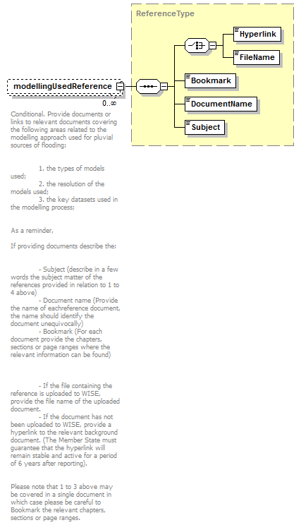 |
||||||||
| namespace | http://water.eionet.europa.eu/schemas/dir200760ec | ||||||||
| type | ReferenceType | ||||||||
| properties |
|
||||||||
| children | Hyperlink FileName Bookmark DocumentName Subject | ||||||||
| annotation |
|
||||||||
| source | <xs:element name="modellingUsedReference" type="fd:ReferenceType" minOccurs="0" maxOccurs="unbounded"> <xs:annotation> <xs:documentation>Conditional. Provide documents or links to relevant documents covering the following areas related to the modelling approach used for pluvial sources of flooding: 1. the types of models used; 2. the resolution of the models used; 3. the key datasets used in the modelling process; As a reminder, If providing documents describe the: - Subject (describe in a few words the subject matter of the references provided in relation to 1 to 4 above) - Document name (Provide the name of eachreference document, the name should identify the document unequivocally) - Bookmark (For each document provide the chapters, sections or page ranges where the relevant information can be found) - If the file containing the reference is uploaded to WISE, provide the file name of the uploaded document. - If the document has not been uploaded to WISE, provide a hyperlink to the relevant background document. (The Member State must guarantee that the hyperlink will remain stable and active for a period of 6 years after reporting). Please note that 1 to 3 above may be covered in a single document in which case please be careful to Bookmark the relevant chapters, sections or page ranges. </xs:documentation> </xs:annotation> </xs:element> |
element Pluvial/elementsLowProbability
| diagram | 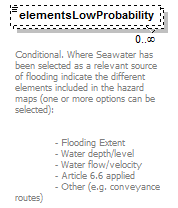 |
|||||||||||||||||||||
| namespace | http://water.eionet.europa.eu/schemas/dir200760ec | |||||||||||||||||||||
| type | ElementsProbability_Enum | |||||||||||||||||||||
| properties |
|
|||||||||||||||||||||
| facets |
|
|||||||||||||||||||||
| annotation |
|
|||||||||||||||||||||
| source | <xs:element name="elementsLowProbability" type="fd:ElementsProbability_Enum" minOccurs="0" maxOccurs="unbounded"> <xs:annotation> <xs:documentation>Conditional. Where Seawater has been selected as a relevant source of flooding indicate the different elements included in the hazard maps (one or more options can be selected): - Flooding Extent - Water depth/level - Water flow/velocity - Article 6.6 applied - Other (e.g. conveyance routes)</xs:documentation> </xs:annotation> </xs:element> |
element Pluvial/elementsLowProbabilityOther
| diagram |  |
|||||||||
| namespace | http://water.eionet.europa.eu/schemas/dir200760ec | |||||||||
| type | String1000Type | |||||||||
| properties |
|
|||||||||
| facets |
|
|||||||||
| annotation |
|
|||||||||
| source | <xs:element name="elementsLowProbabilityOther" type="fd:String1000Type" minOccurs="0"> <xs:annotation> <xs:documentation>Conditional. If ‘Other’ selected Provide a description</xs:documentation> </xs:annotation> </xs:element> |
element Pluvial/elementsMediumProbability
| diagram |  |
|||||||||||||||||||||
| namespace | http://water.eionet.europa.eu/schemas/dir200760ec | |||||||||||||||||||||
| type | ElementsProbability_Enum | |||||||||||||||||||||
| properties |
|
|||||||||||||||||||||
| facets |
|
|||||||||||||||||||||
| annotation |
|
|||||||||||||||||||||
| source | <xs:element name="elementsMediumProbability" type="fd:ElementsProbability_Enum" minOccurs="0" maxOccurs="unbounded"> <xs:annotation> <xs:documentation>Conditional. Where Seawater has been selected as a relevant source of flooding indicate the different elements included in the hazard maps (one or more options can be selected): - Flooding Extent - Water depth/level - Water flow/velocity - Article 6.6 applied - Other (e.g. conveyance routes)</xs:documentation> </xs:annotation> </xs:element> |
element Pluvial/elementsMediumProbabilityOther
| diagram |  |
|||||||||
| namespace | http://water.eionet.europa.eu/schemas/dir200760ec | |||||||||
| type | String1000Type | |||||||||
| properties |
|
|||||||||
| facets |
|
|||||||||
| annotation |
|
|||||||||
| source | <xs:element name="elementsMediumProbabilityOther" type="fd:String1000Type" minOccurs="0"> <xs:annotation> <xs:documentation>Conditional. If ‘Other’ selected Provide a description</xs:documentation> </xs:annotation> </xs:element> |
element Pluvial/elementsHighProbability
| diagram |  |
|||||||||||||||||||||
| namespace | http://water.eionet.europa.eu/schemas/dir200760ec | |||||||||||||||||||||
| type | ElementsProbability_Enum | |||||||||||||||||||||
| properties |
|
|||||||||||||||||||||
| facets |
|
|||||||||||||||||||||
| annotation |
|
|||||||||||||||||||||
| source | <xs:element name="elementsHighProbability" type="fd:ElementsProbability_Enum" minOccurs="0" maxOccurs="unbounded"> <xs:annotation> <xs:documentation>Conditional. Where Seawater has been selected as a relevant source of flooding indicate the different elements included in the hazard maps (one or more options can be selected): - Flooding Extent - Water depth/level - Water flow/velocity - Article 6.6 applied - Other (e.g. conveyance routes)</xs:documentation> </xs:annotation> </xs:element> |
element Pluvial/elementsHighProbabilityOther
| diagram | 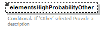 |
|||||||||
| namespace | http://water.eionet.europa.eu/schemas/dir200760ec | |||||||||
| type | String1000Type | |||||||||
| properties |
|
|||||||||
| facets |
|
|||||||||
| annotation |
|
|||||||||
| source | <xs:element name="elementsHighProbabilityOther" type="fd:String1000Type" minOccurs="0"> <xs:annotation> <xs:documentation>Conditional. If ‘Other’ selected Provide a description</xs:documentation> </xs:annotation> </xs:element> |
element Pluvial/Low
| diagram |  |
||||
| namespace | http://water.eionet.europa.eu/schemas/dir200760ec | ||||
| type | Low | ||||
| properties |
|
||||
| children | FloodingExtent DepthsOrWaterLevels VelocitiesOrFlows Other | ||||
| source | <xs:element name="Low" type="Low"/> |
element Pluvial/High
| diagram |  |
||||
| namespace | http://water.eionet.europa.eu/schemas/dir200760ec | ||||
| type | High | ||||
| properties |
|
||||
| children | FloodingExtent DepthsOrWaterLevels VelocitiesOrFlows Other | ||||
| source | <xs:element name="High" type="High"/> |
element Pluvial/Medium
| diagram | 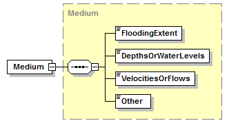 |
||||
| namespace | http://water.eionet.europa.eu/schemas/dir200760ec | ||||
| type | Medium | ||||
| properties |
|
||||
| children | FloodingExtent DepthsOrWaterLevels VelocitiesOrFlows Other | ||||
| source | <xs:element name="Medium" type="Medium"/> |
complexType Probability
| diagram |  |
||
| namespace | http://water.eionet.europa.eu/schemas/dir200760ec | ||
| children | descriptionOfProbability frequency recurrence probabilityOfOccurence | ||
| used by |
|
||
| annotation |
|
||
| source | <xs:complexType name="Probability"> <xs:annotation> <xs:documentation>At least one of the three elements should be reported</xs:documentation> </xs:annotation> <xs:sequence> <xs:element name="descriptionOfProbability" type="fd:ReferenceType" minOccurs="0"> <xs:annotation> <xs:documentation>Provide a description as to what level of probably is considered to be low, for example = 1000 year return period</xs:documentation> </xs:annotation> </xs:element> <xs:element name="frequency" type="fd:String50Type" minOccurs="0"> <xs:annotation> <xs:documentation>The statistical prediction of years between certain flood magnitude events. Can also be reported as a range.The exception types -9999=Unknown, -8888=Yet to be measured, -7777=Not Applicable can be used.</xs:documentation> </xs:annotation> </xs:element> <xs:element name="recurrence" type="fd:String50Type" minOccurs="0"> <xs:annotation> <xs:documentation> The average number of years between floods of a certain size. Can also be reported as a range. The exception types -9999=Unknown, -8888=Yet to be measured, -7777=Not Applicable can be used.</xs:documentation> </xs:annotation> </xs:element> <xs:element name="probabilityOfOccurence" type="fd:String50Type" minOccurs="0"> <xs:annotation> <xs:documentation>ProbabilityofExceedance or ProbabilityofOccurence expressed as a percentage, of a flood event of a given magnitude occurring or being exceeded during any given year. The exception types -9999=Unknown, -8888=Yet to be measured, -7777=Not Applicable can be used.</xs:documentation> </xs:annotation> </xs:element> </xs:sequence> </xs:complexType> |
element Probability/descriptionOfProbability
| diagram | 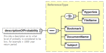 |
||||||||
| namespace | http://water.eionet.europa.eu/schemas/dir200760ec | ||||||||
| type | ReferenceType | ||||||||
| properties |
|
||||||||
| children | Hyperlink FileName Bookmark DocumentName Subject | ||||||||
| annotation |
|
||||||||
| source | <xs:element name="descriptionOfProbability" type="fd:ReferenceType" minOccurs="0"> <xs:annotation> <xs:documentation>Provide a description as to what level of probably is considered to be low, for example = 1000 year return period</xs:documentation> </xs:annotation> </xs:element> |
element Probability/frequency
| diagram |  |
|||||||||
| namespace | http://water.eionet.europa.eu/schemas/dir200760ec | |||||||||
| type | String50Type | |||||||||
| properties |
|
|||||||||
| facets |
|
|||||||||
| annotation |
|
|||||||||
| source | <xs:element name="frequency" type="fd:String50Type" minOccurs="0"> <xs:annotation> <xs:documentation>The statistical prediction of years between certain flood magnitude events. Can also be reported as a range.The exception types -9999=Unknown, -8888=Yet to be measured, -7777=Not Applicable can be used.</xs:documentation> </xs:annotation> </xs:element> |
element Probability/recurrence
| diagram |  |
|||||||||
| namespace | http://water.eionet.europa.eu/schemas/dir200760ec | |||||||||
| type | String50Type | |||||||||
| properties |
|
|||||||||
| facets |
|
|||||||||
| annotation |
|
|||||||||
| source | <xs:element name="recurrence" type="fd:String50Type" minOccurs="0"> <xs:annotation> <xs:documentation> The average number of years between floods of a certain size. Can also be reported as a range. The exception types -9999=Unknown, -8888=Yet to be measured, -7777=Not Applicable can be used.</xs:documentation> </xs:annotation> </xs:element> |
element Probability/probabilityOfOccurence
| diagram |  |
|||||||||
| namespace | http://water.eionet.europa.eu/schemas/dir200760ec | |||||||||
| type | String50Type | |||||||||
| properties |
|
|||||||||
| facets |
|
|||||||||
| annotation |
|
|||||||||
| source | <xs:element name="probabilityOfOccurence" type="fd:String50Type" minOccurs="0"> <xs:annotation> <xs:documentation>ProbabilityofExceedance or ProbabilityofOccurence expressed as a percentage, of a flood event of a given magnitude occurring or being exceeded during any given year. The exception types -9999=Unknown, -8888=Yet to be measured, -7777=Not Applicable can be used.</xs:documentation> </xs:annotation> </xs:element> |
complexType ProtectedAreas
| diagram | 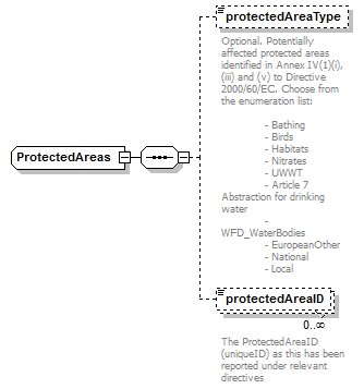 |
||
| namespace | http://water.eionet.europa.eu/schemas/dir200760ec | ||
| children | protectedAreaType protectedAreaID | ||
| used by |
|
||
| source | <xs:complexType name="ProtectedAreas"> <xs:sequence> <xs:element name="protectedAreaType" type="fd:ProtectedAreaType_Enum" minOccurs="0"> <xs:annotation> <xs:documentation>Optional. Potentially affected protected areas identified in Annex IV(1)(i), (iii) and (v) to Directive 2000/60/EC. Choose from the enumeration list: - Bathing - Birds - Habitats - Nitrates - UWWT - Article 7 Abstraction for drinking water - WFD_WaterBodies - EuropeanOther - National - Local</xs:documentation> </xs:annotation> </xs:element> <xs:element name="protectedAreaID" type="fd:String100Type" minOccurs="0" maxOccurs="unbounded"> <xs:annotation> <xs:documentation>The ProtectedAreaID (uniqueID) as this has been reported under relevant directives</xs:documentation> </xs:annotation> </xs:element> </xs:sequence> </xs:complexType> |
element ProtectedAreas/protectedAreaType
| diagram | 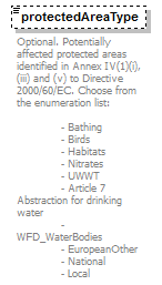 |
|||||||||||||||||||||||||||||||||
| namespace | http://water.eionet.europa.eu/schemas/dir200760ec | |||||||||||||||||||||||||||||||||
| type | ProtectedAreaType_Enum | |||||||||||||||||||||||||||||||||
| properties |
|
|||||||||||||||||||||||||||||||||
| facets |
|
|||||||||||||||||||||||||||||||||
| annotation |
|
|||||||||||||||||||||||||||||||||
| source | <xs:element name="protectedAreaType" type="fd:ProtectedAreaType_Enum" minOccurs="0"> <xs:annotation> <xs:documentation>Optional. Potentially affected protected areas identified in Annex IV(1)(i), (iii) and (v) to Directive 2000/60/EC. Choose from the enumeration list: - Bathing - Birds - Habitats - Nitrates - UWWT - Article 7 Abstraction for drinking water - WFD_WaterBodies - EuropeanOther - National - Local</xs:documentation> </xs:annotation> </xs:element> |
element ProtectedAreas/protectedAreaID
| diagram | 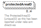 |
|||||||||
| namespace | http://water.eionet.europa.eu/schemas/dir200760ec | |||||||||
| type | String100Type | |||||||||
| properties |
|
|||||||||
| facets |
|
|||||||||
| annotation |
|
|||||||||
| source | <xs:element name="protectedAreaID" type="fd:String100Type" minOccurs="0" maxOccurs="unbounded"> <xs:annotation> <xs:documentation>The ProtectedAreaID (uniqueID) as this has been reported under relevant directives</xs:documentation> </xs:annotation> </xs:element> |
complexType QuantitativeLikelihood
| diagram | 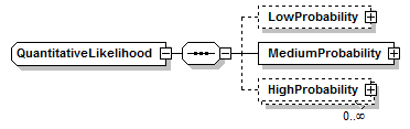 |
||
| namespace | http://water.eionet.europa.eu/schemas/dir200760ec | ||
| children | LowProbability MediumProbability HighProbability | ||
| used by |
|
||
| source | <xs:complexType name="QuantitativeLikelihood"> <xs:sequence> <xs:element name="LowProbability" type="LowProbability" minOccurs="0"/> <xs:element name="MediumProbability" type="MediumProbability"/> <xs:element name="HighProbability" type="HighProbability" minOccurs="0" maxOccurs="unbounded"/> </xs:sequence> </xs:complexType> |
element QuantitativeLikelihood/LowProbability
| diagram | 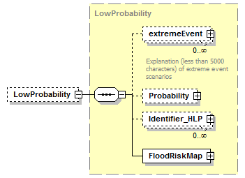 |
||||||||
| namespace | http://water.eionet.europa.eu/schemas/dir200760ec | ||||||||
| type | LowProbability | ||||||||
| properties |
|
||||||||
| children | extremeEvent Probability Identifier_HLP FloodRiskMap | ||||||||
| source | <xs:element name="LowProbability" type="LowProbability" minOccurs="0"/> |
element QuantitativeLikelihood/MediumProbability
| diagram | 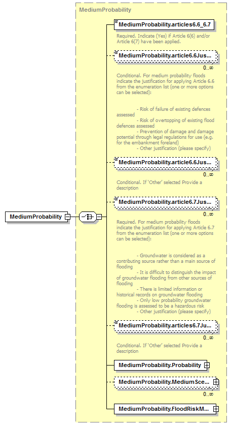 |
||||
| namespace | http://water.eionet.europa.eu/schemas/dir200760ec | ||||
| type | MediumProbability | ||||
| properties |
|
||||
| children | MediumProbability.articles6.6_6.7 MediumProbability.article6.6Justification MediumProbability.article6.6JustificationOther MediumProbability.article6.7Justification MediumProbability.articles6.7JustificationOther MediumProbability.Probability MediumProbability.MediumScenario MediumProbability.FloodRiskMap | ||||
| source | <xs:element name="MediumProbability" type="MediumProbability"/> |
element QuantitativeLikelihood/HighProbability
| diagram | 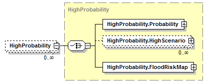 |
||||||||
| namespace | http://water.eionet.europa.eu/schemas/dir200760ec | ||||||||
| type | HighProbability | ||||||||
| properties |
|
||||||||
| children | HighProbability.Probability HighProbability.HighScenario HighProbability.FloodRiskMap | ||||||||
| source | <xs:element name="HighProbability" type="HighProbability" minOccurs="0" maxOccurs="unbounded"/> |
complexType RelevantSourcesSelected
| diagram | 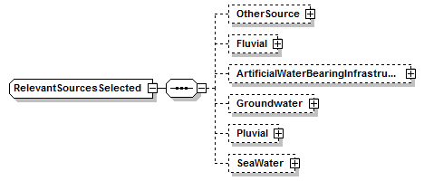 |
||
| namespace | http://water.eionet.europa.eu/schemas/dir200760ec | ||
| children | OtherSource Fluvial ArtificialWaterBearingInfrastructure Groundwater Pluvial SeaWater | ||
| used by |
|
||
| source | <xs:complexType name="RelevantSourcesSelected"> <xs:sequence> <xs:element name="OtherSource" type="OtherSource" minOccurs="0"/> <xs:element name="Fluvial" type="Fluvial" minOccurs="0"/> <xs:element name="ArtificialWaterBearingInfrastructure" type="ArtificialWaterBearingInfrastructure" minOccurs="0"/> <xs:element name="Groundwater" type="Groundwater" minOccurs="0"/> <xs:element name="Pluvial" type="Pluvial" minOccurs="0"/> <xs:element name="SeaWater" type="SeaWater" minOccurs="0"/> </xs:sequence> </xs:complexType> |
element RelevantSourcesSelected/OtherSource
| diagram | 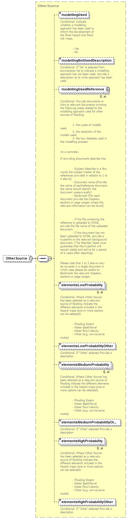 |
||||||||
| namespace | http://water.eionet.europa.eu/schemas/dir200760ec | ||||||||
| type | OtherSource | ||||||||
| properties |
|
||||||||
| children | modellingUsed modellingNotUsedDescription modellingUsedReference elementsLowProbability elementsLowProbabilitlyOther elementsMediumProbability elementsMediumProbabilitlyOther elementsHighProbability elementsHighProbabilitlyOther | ||||||||
| source | <xs:element name="OtherSource" type="OtherSource" minOccurs="0"/> |
element RelevantSourcesSelected/Fluvial
| diagram |  |
||||||||
| namespace | http://water.eionet.europa.eu/schemas/dir200760ec | ||||||||
| type | Fluvial | ||||||||
| properties |
|
||||||||
| children | modellingUsed modellingUsedDescription modellingUsedReference elementsLowProbability elementsLowProbabilityOther elementsMediumProbability elementsMediumProbabilityOther elementsHighProbability elementsHighProbabilityOther Low High Medium | ||||||||
| source | <xs:element name="Fluvial" type="Fluvial" minOccurs="0"/> |
element RelevantSourcesSelected/ArtificialWaterBearingInfrastructure
| diagram | 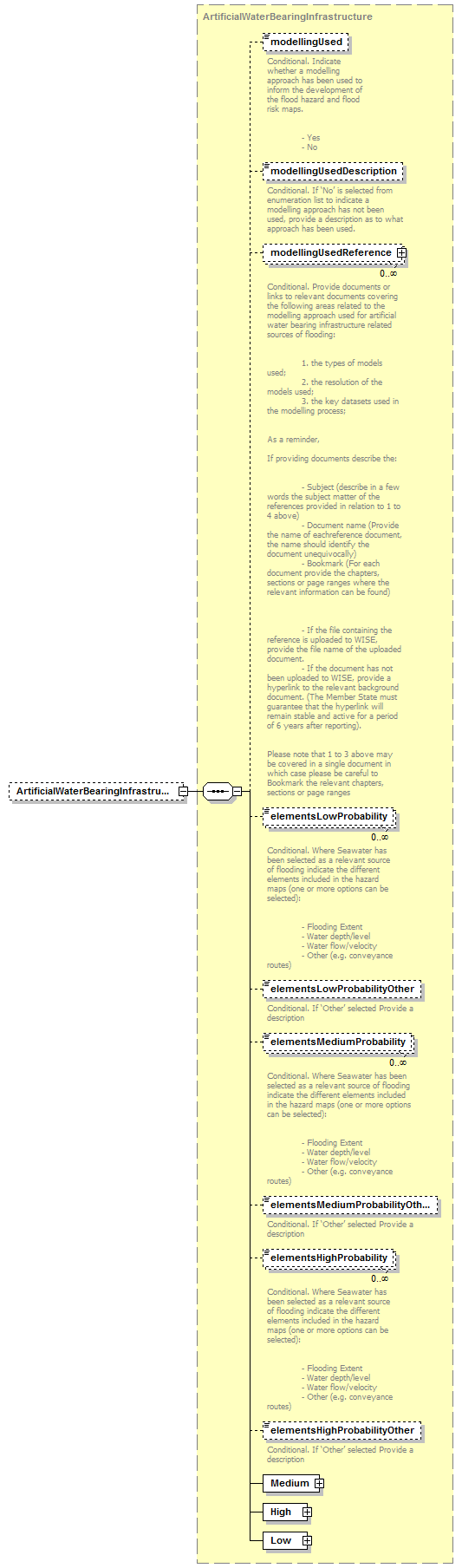 |
||||||||
| namespace | http://water.eionet.europa.eu/schemas/dir200760ec | ||||||||
| type | ArtificialWaterBearingInfrastructure | ||||||||
| properties |
|
||||||||
| children | modellingUsed modellingUsedDescription modellingUsedReference elementsLowProbability elementsLowProbabilityOther elementsMediumProbability elementsMediumProbabilityOther elementsHighProbability elementsHighProbabilityOther Medium High Low | ||||||||
| source | <xs:element name="ArtificialWaterBearingInfrastructure" type="ArtificialWaterBearingInfrastructure" minOccurs="0"/> |
element RelevantSourcesSelected/Groundwater
| diagram | 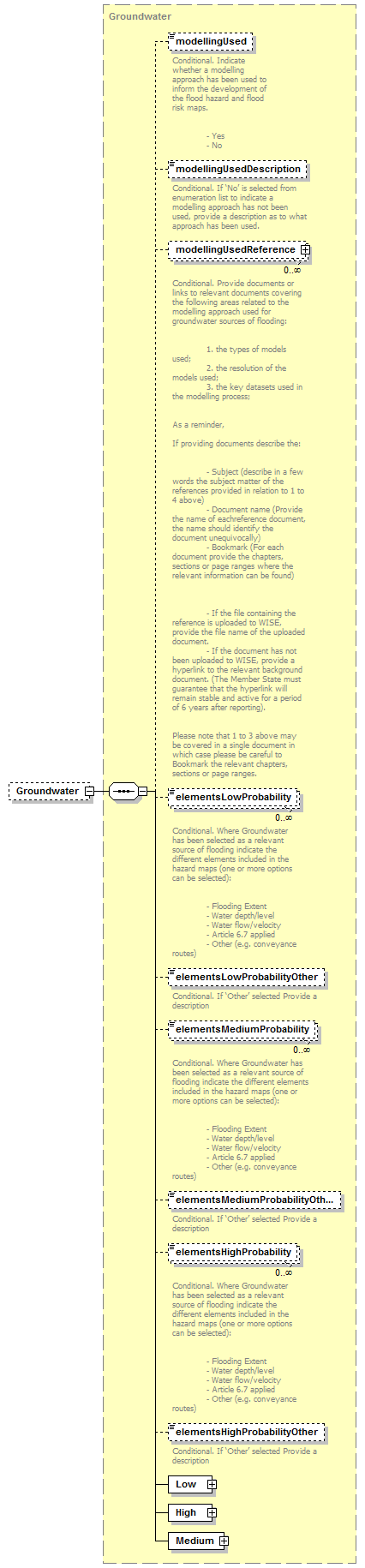 |
||||||||
| namespace | http://water.eionet.europa.eu/schemas/dir200760ec | ||||||||
| type | Groundwater | ||||||||
| properties |
|
||||||||
| children | modellingUsed modellingUsedDescription modellingUsedReference elementsLowProbability elementsLowProbabilityOther elementsMediumProbability elementsMediumProbabilityOther elementsHighProbability elementsHighProbabilityOther Low High Medium | ||||||||
| source | <xs:element name="Groundwater" type="Groundwater" minOccurs="0"/> |
element RelevantSourcesSelected/Pluvial
| diagram |  |
||||||||
| namespace | http://water.eionet.europa.eu/schemas/dir200760ec | ||||||||
| type | Pluvial | ||||||||
| properties |
|
||||||||
| children | modellingUsed modellingUsedDescription modellingUsedReference elementsLowProbability elementsLowProbabilityOther elementsMediumProbability elementsMediumProbabilityOther elementsHighProbability elementsHighProbabilityOther Low High Medium | ||||||||
| source | <xs:element name="Pluvial" type="Pluvial" minOccurs="0"/> |
element RelevantSourcesSelected/SeaWater
| diagram |  |
||||||||
| namespace | http://water.eionet.europa.eu/schemas/dir200760ec | ||||||||
| type | SeaWater | ||||||||
| properties |
|
||||||||
| children | modellingUsed modellingUsedDescription modellingUsedReference elementsLowProbability elementsLowProbabilityOther elementsMediumProbability elementsMediumProbabilityOther elementsHighProbability elementsHighProbabilityOther High Low Medium | ||||||||
| source | <xs:element name="SeaWater" type="SeaWater" minOccurs="0"/> |
complexType SeaWater
| diagram | 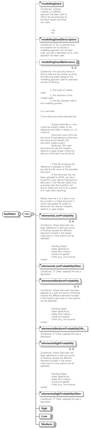 |
||
| namespace | http://water.eionet.europa.eu/schemas/dir200760ec | ||
| children | modellingUsed modellingUsedDescription modellingUsedReference elementsLowProbability elementsLowProbabilityOther elementsMediumProbability elementsMediumProbabilityOther elementsHighProbability elementsHighProbabilityOther High Low Medium | ||
| used by |
|
||
| source | <xs:complexType name="SeaWater"> <xs:sequence> <xs:element name="modellingUsed" type="fd:YesNoCode" minOccurs="0"> <xs:annotation> <xs:documentation>Conditional. Indicate whether a modelling approach has been used to inform the development of the flood hazard and flood risk maps. - Yes - No</xs:documentation> </xs:annotation> </xs:element> <xs:element name="modellingUsedDescription" type="fd:String1000Type" minOccurs="0"> <xs:annotation> <xs:documentation>Conditional. If ‘No’ is selected from enumeration list to indicate a modelling approach has not been used, provide a description as to what approach has been used.</xs:documentation> </xs:annotation> </xs:element> <xs:element name="modellingUsedReference" type="fd:ReferenceType" minOccurs="0" maxOccurs="unbounded"> <xs:annotation> <xs:documentation>Conditional. Provide documents or links to relevant documents covering the following areas related to the modelling approach used for seawater sources of flooding: 1. the types of models used; 2. the resolution of the models used; 3. the key datasets used in the modelling process; As a reminder, If providing documents describe the: - Subject (describe in a few words the subject matter of the references provided in relation to 1 to 4 above) - Document name (Provide the name of eachreference document, the name should identify the document unequivocally) - Bookmark (For each document provide the chapters, sections or page ranges where the relevant information can be found) - If the file containing the reference is uploaded to WISE, provide the file name of the uploaded document. - If the document has not been uploaded to WISE, provide a hyperlink to the relevant background document. (The Member State must guarantee that the hyperlink will remain stable and active for a period of 6 years after reporting). Please note that 1 to 3 above may be covered in a single document in which case please be careful to Bookmark the relevant chapters, sections or page ranges. </xs:documentation> </xs:annotation> </xs:element> <xs:element name="elementsLowProbability" type="fd:ElementsProbability_Enum" minOccurs="0" maxOccurs="unbounded"> <xs:annotation> <xs:documentation>Conditional. Where Seawater has been selected as a relevant source of flooding indicate the different elements included in the hazard maps (one or more options can be selected): - Flooding Extent - Water depth/level - Water flow/velocity - Article 6.6 applied - Other (e.g. conveyance routes)</xs:documentation> </xs:annotation> </xs:element> <xs:element name="elementsLowProbabilityOther" type="fd:String1000Type" minOccurs="0"> <xs:annotation> <xs:documentation>Conditional. If ‘Other’ selected Provide a description</xs:documentation> </xs:annotation> </xs:element> <xs:element name="elementsMediumProbability" type="fd:ElementsProbability_Enum" minOccurs="0" maxOccurs="unbounded"> <xs:annotation> <xs:documentation>Conditional. Where Seawater has been selected as a relevant source of flooding indicate the different elements included in the hazard maps (one or more options can be selected): - Flooding Extent - Water depth/level - Water flow/velocity - Article 6.6 applied - Other (e.g. conveyance routes)</xs:documentation> </xs:annotation> </xs:element> <xs:element name="elementsMediumProbabilityOther" type="fd:String1000Type" minOccurs="0"> <xs:annotation> <xs:documentation>Conditional. If ‘Other’ selected Provide a description</xs:documentation> </xs:annotation> </xs:element> <xs:element name="elementsHighProbability" type="fd:ElementsProbability_Enum" minOccurs="0" maxOccurs="unbounded"> <xs:annotation> <xs:documentation>Conditional. Where Seawater has been selected as a relevant source of flooding indicate the different elements included in the hazard maps (one or more options can be selected): - Flooding Extent - Water depth/level - Water flow/velocity - Article 6.6 applied - Other (e.g. conveyance routes)</xs:documentation> </xs:annotation> </xs:element> <xs:element name="elementsHighProbabilityOther" type="fd:String1000Type" minOccurs="0"> <xs:annotation> <xs:documentation>Conditional. If ‘Other’ selected Provide a description</xs:documentation> </xs:annotation> </xs:element> <xs:element name="High" type="High"/> <xs:element name="Low" type="Low"/> <xs:element name="Medium" type="Medium"/> </xs:sequence> </xs:complexType> |
element SeaWater/modellingUsed
| diagram |  |
||||||||||||
| namespace | http://water.eionet.europa.eu/schemas/dir200760ec | ||||||||||||
| type | YesNoCode | ||||||||||||
| properties |
|
||||||||||||
| facets |
|
||||||||||||
| annotation |
|
||||||||||||
| source | <xs:element name="modellingUsed" type="fd:YesNoCode" minOccurs="0"> <xs:annotation> <xs:documentation>Conditional. Indicate whether a modelling approach has been used to inform the development of the flood hazard and flood risk maps. - Yes - No</xs:documentation> </xs:annotation> </xs:element> |
element SeaWater/modellingUsedDescription
| diagram | 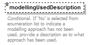 |
|||||||||
| namespace | http://water.eionet.europa.eu/schemas/dir200760ec | |||||||||
| type | String1000Type | |||||||||
| properties |
|
|||||||||
| facets |
|
|||||||||
| annotation |
|
|||||||||
| source | <xs:element name="modellingUsedDescription" type="fd:String1000Type" minOccurs="0"> <xs:annotation> <xs:documentation>Conditional. If ‘No’ is selected from enumeration list to indicate a modelling approach has not been used, provide a description as to what approach has been used.</xs:documentation> </xs:annotation> </xs:element> |
element SeaWater/modellingUsedReference
| diagram | 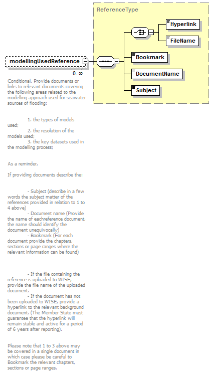 |
||||||||
| namespace | http://water.eionet.europa.eu/schemas/dir200760ec | ||||||||
| type | ReferenceType | ||||||||
| properties |
|
||||||||
| children | Hyperlink FileName Bookmark DocumentName Subject | ||||||||
| annotation |
|
||||||||
| source | <xs:element name="modellingUsedReference" type="fd:ReferenceType" minOccurs="0" maxOccurs="unbounded"> <xs:annotation> <xs:documentation>Conditional. Provide documents or links to relevant documents covering the following areas related to the modelling approach used for seawater sources of flooding: 1. the types of models used; 2. the resolution of the models used; 3. the key datasets used in the modelling process; As a reminder, If providing documents describe the: - Subject (describe in a few words the subject matter of the references provided in relation to 1 to 4 above) - Document name (Provide the name of eachreference document, the name should identify the document unequivocally) - Bookmark (For each document provide the chapters, sections or page ranges where the relevant information can be found) - If the file containing the reference is uploaded to WISE, provide the file name of the uploaded document. - If the document has not been uploaded to WISE, provide a hyperlink to the relevant background document. (The Member State must guarantee that the hyperlink will remain stable and active for a period of 6 years after reporting). Please note that 1 to 3 above may be covered in a single document in which case please be careful to Bookmark the relevant chapters, sections or page ranges. </xs:documentation> </xs:annotation> </xs:element> |
element SeaWater/elementsLowProbability
| diagram | 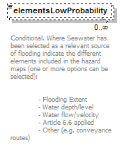 |
|||||||||||||||||||||
| namespace | http://water.eionet.europa.eu/schemas/dir200760ec | |||||||||||||||||||||
| type | ElementsProbability_Enum | |||||||||||||||||||||
| properties |
|
|||||||||||||||||||||
| facets |
|
|||||||||||||||||||||
| annotation |
|
|||||||||||||||||||||
| source | <xs:element name="elementsLowProbability" type="fd:ElementsProbability_Enum" minOccurs="0" maxOccurs="unbounded"> <xs:annotation> <xs:documentation>Conditional. Where Seawater has been selected as a relevant source of flooding indicate the different elements included in the hazard maps (one or more options can be selected): - Flooding Extent - Water depth/level - Water flow/velocity - Article 6.6 applied - Other (e.g. conveyance routes)</xs:documentation> </xs:annotation> </xs:element> |
element SeaWater/elementsLowProbabilityOther
| diagram |  |
|||||||||
| namespace | http://water.eionet.europa.eu/schemas/dir200760ec | |||||||||
| type | String1000Type | |||||||||
| properties |
|
|||||||||
| facets |
|
|||||||||
| annotation |
|
|||||||||
| source | <xs:element name="elementsLowProbabilityOther" type="fd:String1000Type" minOccurs="0"> <xs:annotation> <xs:documentation>Conditional. If ‘Other’ selected Provide a description</xs:documentation> </xs:annotation> </xs:element> |
element SeaWater/elementsMediumProbability
| diagram | 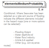 |
|||||||||||||||||||||
| namespace | http://water.eionet.europa.eu/schemas/dir200760ec | |||||||||||||||||||||
| type | ElementsProbability_Enum | |||||||||||||||||||||
| properties |
|
|||||||||||||||||||||
| facets |
|
|||||||||||||||||||||
| annotation |
|
|||||||||||||||||||||
| source | <xs:element name="elementsMediumProbability" type="fd:ElementsProbability_Enum" minOccurs="0" maxOccurs="unbounded"> <xs:annotation> <xs:documentation>Conditional. Where Seawater has been selected as a relevant source of flooding indicate the different elements included in the hazard maps (one or more options can be selected): - Flooding Extent - Water depth/level - Water flow/velocity - Article 6.6 applied - Other (e.g. conveyance routes)</xs:documentation> </xs:annotation> </xs:element> |
element SeaWater/elementsMediumProbabilityOther
| diagram |  |
|||||||||
| namespace | http://water.eionet.europa.eu/schemas/dir200760ec | |||||||||
| type | String1000Type | |||||||||
| properties |
|
|||||||||
| facets |
|
|||||||||
| annotation |
|
|||||||||
| source | <xs:element name="elementsMediumProbabilityOther" type="fd:String1000Type" minOccurs="0"> <xs:annotation> <xs:documentation>Conditional. If ‘Other’ selected Provide a description</xs:documentation> </xs:annotation> </xs:element> |
element SeaWater/elementsHighProbability
| diagram | 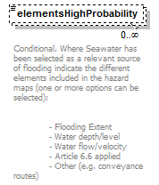 |
|||||||||||||||||||||
| namespace | http://water.eionet.europa.eu/schemas/dir200760ec | |||||||||||||||||||||
| type | ElementsProbability_Enum | |||||||||||||||||||||
| properties |
|
|||||||||||||||||||||
| facets |
|
|||||||||||||||||||||
| annotation |
|
|||||||||||||||||||||
| source | <xs:element name="elementsHighProbability" type="fd:ElementsProbability_Enum" minOccurs="0" maxOccurs="unbounded"> <xs:annotation> <xs:documentation>Conditional. Where Seawater has been selected as a relevant source of flooding indicate the different elements included in the hazard maps (one or more options can be selected): - Flooding Extent - Water depth/level - Water flow/velocity - Article 6.6 applied - Other (e.g. conveyance routes)</xs:documentation> </xs:annotation> </xs:element> |
element SeaWater/elementsHighProbabilityOther
| diagram |  |
|||||||||
| namespace | http://water.eionet.europa.eu/schemas/dir200760ec | |||||||||
| type | String1000Type | |||||||||
| properties |
|
|||||||||
| facets |
|
|||||||||
| annotation |
|
|||||||||
| source | <xs:element name="elementsHighProbabilityOther" type="fd:String1000Type" minOccurs="0"> <xs:annotation> <xs:documentation>Conditional. If ‘Other’ selected Provide a description</xs:documentation> </xs:annotation> </xs:element> |
element SeaWater/High
| diagram |  |
||||
| namespace | http://water.eionet.europa.eu/schemas/dir200760ec | ||||
| type | High | ||||
| properties |
|
||||
| children | FloodingExtent DepthsOrWaterLevels VelocitiesOrFlows Other | ||||
| source | <xs:element name="High" type="High"/> |
element SeaWater/Low
| diagram |  |
||||
| namespace | http://water.eionet.europa.eu/schemas/dir200760ec | ||||
| type | Low | ||||
| properties |
|
||||
| children | FloodingExtent DepthsOrWaterLevels VelocitiesOrFlows Other | ||||
| source | <xs:element name="Low" type="Low"/> |
element SeaWater/Medium
| diagram |  |
||||
| namespace | http://water.eionet.europa.eu/schemas/dir200760ec | ||||
| type | Medium | ||||
| properties |
|
||||
| children | FloodingExtent DepthsOrWaterLevels VelocitiesOrFlows Other | ||||
| source | <xs:element name="Medium" type="Medium"/> |
complexType Summary1
| diagram | 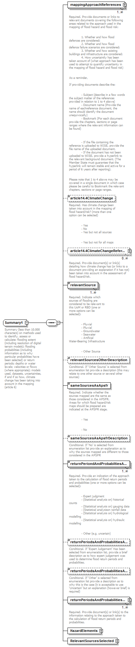 |
||
| namespace | http://water.eionet.europa.eu/schemas/dir200760ec | ||
| children | mappingApproachReferences article14.4ClimateChange article14.4ClimateChangeReference relavantSource relevantSourcesOtherDescription sameSourcesAsApsfr sameSourcesAsApsfrDescription returnPeriondAndProbabiltiesApproach returnPeriodsAndProbabilitiesApproachExpertJudgementDescription returnPeriodsAndProbabilitiesApproachOther returnPeriodsAndProbabilitiesApproachReference HazardElements RelevantSourcesSelected | ||
| used by |
|
||
| annotation |
|
||
| source | <xs:complexType name="Summary1"> <xs:annotation> <xs:documentation>Summary (less than 10.000 characters) on methods used to identify, assess or calculate: flooding extent (including resolution of digital terrain models); flooding probabilities (including information as to why particular probabilities have been selected) or return periods; depths or water levels; velocities or flows (where appropriate); models used, datasets, uncertainties, if and if so how, climate change has been taking into account in the mapping (article 6)</xs:documentation> </xs:annotation> <xs:sequence> <xs:element name="mappingApproachReferences" type="fd:ReferenceType" maxOccurs="unbounded"> <xs:annotation> <xs:documentation>Required. Provide documents or links to relevant documents covering the following areas related to the approach used in the mapping of flood hazard and flood risk: 1. Whether and how flood defences are considered; 2. Whether and how flood defence failure scenarios are considered; 3. Whether and how existing buildings and infrastructure are considered; 4. How uncertaintly has been taken account of (what approach has been used to attempt to quantify uncertianty in the mapping of flood hazard and flood risk) As a reminder, If providing documents describe the: - Subject (describe in a few words the subject matter of the references provided in relation to 1 to 4 above) - Document name (Provide the name of eachreference document, the name should identify the document unequivocally) - Bookmark (For each document provide the chapters, sections or page ranges where the relevant information can be found) - If the file containing the reference is uploaded to WISE, provide the file name of the uploaded document. - If the document has not been uploaded to WISE, provide a hyperlink to the relevant background document. (The Member State must guarantee that the hyperlink will remain stable and active for a period of 6 years after reporting). Please note that 1 to 4 above may be covered in a single document in which case please be careful to Bookmark the relevant chapters, sections or page ranges. </xs:documentation> </xs:annotation> </xs:element> <xs:element name="article14.4ClimateChange" type="fd:YesNoCode" minOccurs="0"> <xs:annotation> <xs:documentation>Required. Has climate change been taken into account in the mapping of flood hazard/risk? (more than one option can be selected) - Yes - No - Yes but not all sources - Yes but not for all maps</xs:documentation> </xs:annotation> </xs:element> <xs:element name="article14.4ClimateChangeReference" type="fd:ReferenceType" minOccurs="0" maxOccurs="unbounded"> <xs:annotation> <xs:documentation>Required. Provide document(s) or link(s) detailing how climate change has (or links to a document providing an explanation if it has not) been taken into account in the assessment of flood hazard/risk. </xs:documentation> </xs:annotation> </xs:element> <xs:element name="relavantSource" type="fd:RelavantSources_Enum" maxOccurs="unbounded"> <xs:annotation> <xs:documentation>Required. Indicate which sources of flooding are considered to be relevant to this UoM or RBD (one or more options can be selected): - Fluvial - Pluvial - Groundwater - Seawater - Artificial Water-Bearing Infrastructure - Other Source</xs:documentation> </xs:annotation> </xs:element> <xs:element name="relevantSourcesOtherDescription" type="fd:String1000Type" minOccurs="0"> <xs:annotation> <xs:documentation>Conditional. If ‘Other Source’ is selected from enumeration list provide a description (this may relate to one other source or several other sources)</xs:documentation> </xs:annotation> </xs:element> <xs:element name="sameSourcesAsApsfr" type="fd:YesNoCode"> <xs:annotation> <xs:documentation>Required. Indicate whether the sources mapped are the same as those considered in the APSFR. Areas for which flood hazard/risk maps should be prepared are indicated at the APSFR stage. - Yes - No</xs:documentation> </xs:annotation> </xs:element> <xs:element name="sameSourcesAsApsfrDescription" type="fd:String1000Type" minOccurs="0"> <xs:annotation> <xs:documentation>Conditional. If ‘No’ is selected from enumeration list provide an explanation as to why the sources mapped are different to those considered in the APSFR</xs:documentation> </xs:annotation> </xs:element> <xs:element name="returnPeriondAndProbabiltiesApproach" type="fd:ReturnperiondandprobabiltiesApproach_Enum" maxOccurs="unbounded"> <xs:annotation> <xs:documentation>Required. Provide an indication of the approach taken to the calculation of flood return periods and probabilities (one or more options can be selected): - Expert judgment - (Statistical analysis on) historical counts - (Statistical analysis on) gauging data - (Statistical analysison rainfall data - (Statistical analysis on) hydrological modelling - (Statistical analysis on) hydraulic modelling - Other (e.g. uncertain)</xs:documentation> </xs:annotation> </xs:element> <xs:element name="returnPeriodsAndProbabilitiesApproachExpertJudgementDescription" type="fd:String100Type" minOccurs="0"> <xs:annotation> <xs:documentation>Conditional. If ‘Expert Judgement’ Has been selected from enumeration list, provide a brief description as to how expert judgement was used to determine flood return periods and probabilities.</xs:documentation> </xs:annotation> </xs:element> <xs:element name="returnPeriodsAndProbabilitiesApproachOther" type="fd:String1000Type" minOccurs="0"> <xs:annotation> <xs:documentation>Conditional. If ‘Other’ is selected from enumeration list provide a description as to why this is the case (it is acceptable to use ‘Uncertain’ but an explanation (however brief) is required)</xs:documentation> </xs:annotation> </xs:element> <xs:element name="returnPeriodsAndProbabilitiesApproachReference" type="fd:ReferenceType" maxOccurs="unbounded"> <xs:annotation> <xs:documentation>Required. Provide document(s) or link(s) to the information relating to the approach taken to the calculation of flood return periods and probabilities. </xs:documentation> </xs:annotation> </xs:element> <xs:element name="HazardElements" type="HazardElements"/> <xs:element name="RelevantSourcesSelected" type="RelevantSourcesSelected"/> </xs:sequence> </xs:complexType> |
element Summary1/mappingApproachReferences
| diagram | 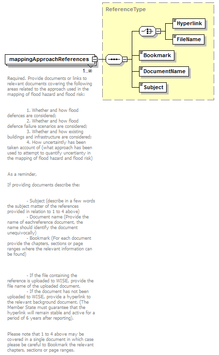 |
||||||||
| namespace | http://water.eionet.europa.eu/schemas/dir200760ec | ||||||||
| type | ReferenceType | ||||||||
| properties |
|
||||||||
| children | Hyperlink FileName Bookmark DocumentName Subject | ||||||||
| annotation |
|
||||||||
| source | <xs:element name="mappingApproachReferences" type="fd:ReferenceType" maxOccurs="unbounded"> <xs:annotation> <xs:documentation>Required. Provide documents or links to relevant documents covering the following areas related to the approach used in the mapping of flood hazard and flood risk: 1. Whether and how flood defences are considered; 2. Whether and how flood defence failure scenarios are considered; 3. Whether and how existing buildings and infrastructure are considered; 4. How uncertaintly has been taken account of (what approach has been used to attempt to quantify uncertianty in the mapping of flood hazard and flood risk) As a reminder, If providing documents describe the: - Subject (describe in a few words the subject matter of the references provided in relation to 1 to 4 above) - Document name (Provide the name of eachreference document, the name should identify the document unequivocally) - Bookmark (For each document provide the chapters, sections or page ranges where the relevant information can be found) - If the file containing the reference is uploaded to WISE, provide the file name of the uploaded document. - If the document has not been uploaded to WISE, provide a hyperlink to the relevant background document. (The Member State must guarantee that the hyperlink will remain stable and active for a period of 6 years after reporting). Please note that 1 to 4 above may be covered in a single document in which case please be careful to Bookmark the relevant chapters, sections or page ranges. </xs:documentation> </xs:annotation> </xs:element> |
element Summary1/article14.4ClimateChange
| diagram | 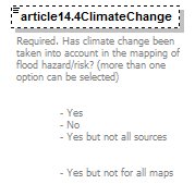 |
||||||||||||
| namespace | http://water.eionet.europa.eu/schemas/dir200760ec | ||||||||||||
| type | YesNoCode | ||||||||||||
| properties |
|
||||||||||||
| facets |
|
||||||||||||
| annotation |
|
||||||||||||
| source | <xs:element name="article14.4ClimateChange" type="fd:YesNoCode" minOccurs="0"> <xs:annotation> <xs:documentation>Required. Has climate change been taken into account in the mapping of flood hazard/risk? (more than one option can be selected) - Yes - No - Yes but not all sources - Yes but not for all maps</xs:documentation> </xs:annotation> </xs:element> |
element Summary1/article14.4ClimateChangeReference
| diagram | 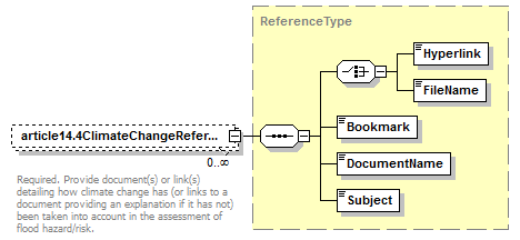 |
||||||||
| namespace | http://water.eionet.europa.eu/schemas/dir200760ec | ||||||||
| type | ReferenceType | ||||||||
| properties |
|
||||||||
| children | Hyperlink FileName Bookmark DocumentName Subject | ||||||||
| annotation |
|
||||||||
| source | <xs:element name="article14.4ClimateChangeReference" type="fd:ReferenceType" minOccurs="0" maxOccurs="unbounded"> <xs:annotation> <xs:documentation>Required. Provide document(s) or link(s) detailing how climate change has (or links to a document providing an explanation if it has not) been taken into account in the assessment of flood hazard/risk. </xs:documentation> </xs:annotation> </xs:element> |
element Summary1/relavantSource
| diagram | 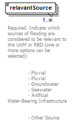 |
|||||||||||||||||||||
| namespace | http://water.eionet.europa.eu/schemas/dir200760ec | |||||||||||||||||||||
| type | RelavantSources_Enum | |||||||||||||||||||||
| properties |
|
|||||||||||||||||||||
| facets |
|
|||||||||||||||||||||
| annotation |
|
|||||||||||||||||||||
| source | <xs:element name="relavantSource" type="fd:RelavantSources_Enum" maxOccurs="unbounded"> <xs:annotation> <xs:documentation>Required. Indicate which sources of flooding are considered to be relevant to this UoM or RBD (one or more options can be selected): - Fluvial - Pluvial - Groundwater - Seawater - Artificial Water-Bearing Infrastructure - Other Source</xs:documentation> </xs:annotation> </xs:element> |
element Summary1/relevantSourcesOtherDescription
| diagram | 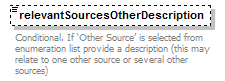 |
|||||||||
| namespace | http://water.eionet.europa.eu/schemas/dir200760ec | |||||||||
| type | String1000Type | |||||||||
| properties |
|
|||||||||
| facets |
|
|||||||||
| annotation |
|
|||||||||
| source | <xs:element name="relevantSourcesOtherDescription" type="fd:String1000Type" minOccurs="0"> <xs:annotation> <xs:documentation>Conditional. If ‘Other Source’ is selected from enumeration list provide a description (this may relate to one other source or several other sources)</xs:documentation> </xs:annotation> </xs:element> |
element Summary1/sameSourcesAsApsfr
| diagram | 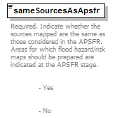 |
||||||||||||
| namespace | http://water.eionet.europa.eu/schemas/dir200760ec | ||||||||||||
| type | YesNoCode | ||||||||||||
| properties |
|
||||||||||||
| facets |
|
||||||||||||
| annotation |
|
||||||||||||
| source | <xs:element name="sameSourcesAsApsfr" type="fd:YesNoCode"> <xs:annotation> <xs:documentation>Required. Indicate whether the sources mapped are the same as those considered in the APSFR. Areas for which flood hazard/risk maps should be prepared are indicated at the APSFR stage. - Yes - No</xs:documentation> </xs:annotation> </xs:element> |
element Summary1/sameSourcesAsApsfrDescription
| diagram | 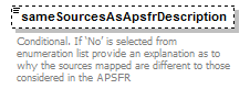 |
|||||||||
| namespace | http://water.eionet.europa.eu/schemas/dir200760ec | |||||||||
| type | String1000Type | |||||||||
| properties |
|
|||||||||
| facets |
|
|||||||||
| annotation |
|
|||||||||
| source | <xs:element name="sameSourcesAsApsfrDescription" type="fd:String1000Type" minOccurs="0"> <xs:annotation> <xs:documentation>Conditional. If ‘No’ is selected from enumeration list provide an explanation as to why the sources mapped are different to those considered in the APSFR</xs:documentation> </xs:annotation> </xs:element> |
element Summary1/returnPeriondAndProbabiltiesApproach
| diagram | 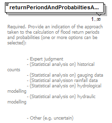 |
||||||||||||||||||||||||
| namespace | http://water.eionet.europa.eu/schemas/dir200760ec | ||||||||||||||||||||||||
| type | ReturnperiondandprobabiltiesApproach_Enum | ||||||||||||||||||||||||
| properties |
|
||||||||||||||||||||||||
| facets |
|
||||||||||||||||||||||||
| annotation |
|
||||||||||||||||||||||||
| source | <xs:element name="returnPeriondAndProbabiltiesApproach" type="fd:ReturnperiondandprobabiltiesApproach_Enum" maxOccurs="unbounded"> <xs:annotation> <xs:documentation>Required. Provide an indication of the approach taken to the calculation of flood return periods and probabilities (one or more options can be selected): - Expert judgment - (Statistical analysis on) historical counts - (Statistical analysis on) gauging data - (Statistical analysison rainfall data - (Statistical analysis on) hydrological modelling - (Statistical analysis on) hydraulic modelling - Other (e.g. uncertain)</xs:documentation> </xs:annotation> </xs:element> |
element Summary1/returnPeriodsAndProbabilitiesApproachExpertJudgementDescription
| diagram | 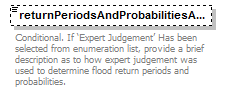 |
|||||||||
| namespace | http://water.eionet.europa.eu/schemas/dir200760ec | |||||||||
| type | String100Type | |||||||||
| properties |
|
|||||||||
| facets |
|
|||||||||
| annotation |
|
|||||||||
| source | <xs:element name="returnPeriodsAndProbabilitiesApproachExpertJudgementDescription" type="fd:String100Type" minOccurs="0"> <xs:annotation> <xs:documentation>Conditional. If ‘Expert Judgement’ Has been selected from enumeration list, provide a brief description as to how expert judgement was used to determine flood return periods and probabilities.</xs:documentation> </xs:annotation> </xs:element> |
element Summary1/returnPeriodsAndProbabilitiesApproachOther
| diagram | 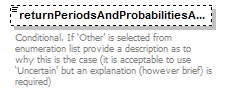 |
|||||||||
| namespace | http://water.eionet.europa.eu/schemas/dir200760ec | |||||||||
| type | String1000Type | |||||||||
| properties |
|
|||||||||
| facets |
|
|||||||||
| annotation |
|
|||||||||
| source | <xs:element name="returnPeriodsAndProbabilitiesApproachOther" type="fd:String1000Type" minOccurs="0"> <xs:annotation> <xs:documentation>Conditional. If ‘Other’ is selected from enumeration list provide a description as to why this is the case (it is acceptable to use ‘Uncertain’ but an explanation (however brief) is required)</xs:documentation> </xs:annotation> </xs:element> |
element Summary1/returnPeriodsAndProbabilitiesApproachReference
| diagram |  |
||||||||
| namespace | http://water.eionet.europa.eu/schemas/dir200760ec | ||||||||
| type | ReferenceType | ||||||||
| properties |
|
||||||||
| children | Hyperlink FileName Bookmark DocumentName Subject | ||||||||
| annotation |
|
||||||||
| source | <xs:element name="returnPeriodsAndProbabilitiesApproachReference" type="fd:ReferenceType" maxOccurs="unbounded"> <xs:annotation> <xs:documentation>Required. Provide document(s) or link(s) to the information relating to the approach taken to the calculation of flood return periods and probabilities. </xs:documentation> </xs:annotation> </xs:element> |
element Summary1/HazardElements
| diagram | 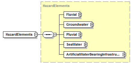 |
||||
| namespace | http://water.eionet.europa.eu/schemas/dir200760ec | ||||
| type | HazardElements | ||||
| properties |
|
||||
| children | Fluvial Groundwater Pluvial SeaWater ArtificialWaterBearingInfrastructure | ||||
| source | <xs:element name="HazardElements" type="HazardElements"/> |
element Summary1/RelevantSourcesSelected
| diagram | 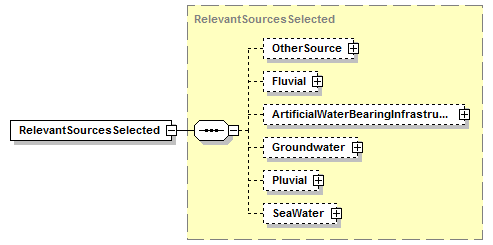 |
||||
| namespace | http://water.eionet.europa.eu/schemas/dir200760ec | ||||
| type | RelevantSourcesSelected | ||||
| properties |
|
||||
| children | OtherSource Fluvial ArtificialWaterBearingInfrastructure Groundwater Pluvial SeaWater | ||||
| source | <xs:element name="RelevantSourcesSelected" type="RelevantSourcesSelected"/> |
complexType Summary3
| diagram | 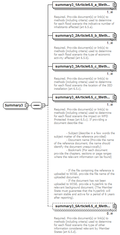 |
||
| namespace | http://water.eionet.europa.eu/schemas/dir200760ec | ||
| children | summary3_1Article6.5_a_MethodInhabitantsAffectedReference summary3_2Article6.5_b_MethodEconomicActivityAffectedReference summary3_3Article6.5_c_MethodLocationIedInstallationReference summary3_4Article6.5_c_MethodWfdProtectedAreasReference summary3_5Article6.5_d_MethodOtherInformationReference | ||
| used by |
|
||
| source | <xs:complexType name="Summary3"> <xs:sequence> <xs:element name="summary3_1Article6.5_a_MethodInhabitantsAffectedReference" type="fd:ReferenceType" maxOccurs="unbounded"> <xs:annotation> <xs:documentation>Required. Provide document(s) or link(s) to methods (including criteria) used to determine for each flood scenario the indicative number of inhabitants affected (art 6.5.a).</xs:documentation> </xs:annotation> </xs:element> <xs:element name="summary3_2Article6.5_b_MethodEconomicActivityAffectedReference" type="fd:ReferenceType" maxOccurs="unbounded"> <xs:annotation> <xs:documentation>Required. Provide document(s) or link(s) to methods (including criteria) used to determine for each flood scenario the type of economic activity affected (art 6.5.b). </xs:documentation> </xs:annotation> </xs:element> <xs:element name="summary3_3Article6.5_c_MethodLocationIedInstallationReference" type="fd:ReferenceType" maxOccurs="unbounded"> <xs:annotation> <xs:documentation>Required. Provide document(s) or link(s) to methods (including criteria) used to determine for each flood scenario the location of the IED installation (art 6.5.c). </xs:documentation> </xs:annotation> </xs:element> <xs:element name="summary3_4Article6.5_c_MethodWfdProtectedAreasReference" type="fd:ReferenceType" maxOccurs="unbounded"> <xs:annotation> <xs:documentation>Required. Provide document(s) or link(s) to methods (including criteria) used to determine for each flood scenario the impact on WFD Protected Areas (art 6.5.c). If providing a document describe the: - Subject (describe in a few words the subject matter of the reference provided) - Document name (Provide the name of the reference document, the name should identify the document unequivocally) - Bookmark (For each document provide the chapters, sections or page ranges where the relevant information can be found) - If the file containing the reference is uploaded to WISE, provide the file name of the uploaded document. - If the document has not been uploaded to WISE, provide a hyperlink to the relevant background document. (The Member State must guarantee that the hyperlink will remain stable and active for a period of 6 years after reporting).</xs:documentation> </xs:annotation> </xs:element> <xs:element name="summary3_5Article6.5_d_MethodOtherInformationReference" type="fd:ReferenceType" minOccurs="0" maxOccurs="unbounded"> <xs:annotation> <xs:documentation>Required. Provide document(s) or link(s) to methods (including criteria) used to determine for each flood scenario the type of other information considered relevant by Member States (art 6.5.d). </xs:documentation> </xs:annotation> </xs:element> </xs:sequence> </xs:complexType> |
element Summary3/summary3_1Article6.5_a_MethodInhabitantsAffectedReference
| diagram | 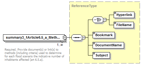 |
||||||||
| namespace | http://water.eionet.europa.eu/schemas/dir200760ec | ||||||||
| type | ReferenceType | ||||||||
| properties |
|
||||||||
| children | Hyperlink FileName Bookmark DocumentName Subject | ||||||||
| annotation |
|
||||||||
| source | <xs:element name="summary3_1Article6.5_a_MethodInhabitantsAffectedReference" type="fd:ReferenceType" maxOccurs="unbounded"> <xs:annotation> <xs:documentation>Required. Provide document(s) or link(s) to methods (including criteria) used to determine for each flood scenario the indicative number of inhabitants affected (art 6.5.a).</xs:documentation> </xs:annotation> </xs:element> |
element Summary3/summary3_2Article6.5_b_MethodEconomicActivityAffectedReference
| diagram | 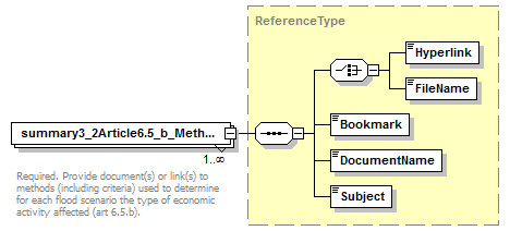 |
||||||||
| namespace | http://water.eionet.europa.eu/schemas/dir200760ec | ||||||||
| type | ReferenceType | ||||||||
| properties |
|
||||||||
| children | Hyperlink FileName Bookmark DocumentName Subject | ||||||||
| annotation |
|
||||||||
| source | <xs:element name="summary3_2Article6.5_b_MethodEconomicActivityAffectedReference" type="fd:ReferenceType" maxOccurs="unbounded"> <xs:annotation> <xs:documentation>Required. Provide document(s) or link(s) to methods (including criteria) used to determine for each flood scenario the type of economic activity affected (art 6.5.b). </xs:documentation> </xs:annotation> </xs:element> |
element Summary3/summary3_3Article6.5_c_MethodLocationIedInstallationReference
| diagram | 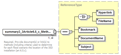 |
||||||||
| namespace | http://water.eionet.europa.eu/schemas/dir200760ec | ||||||||
| type | ReferenceType | ||||||||
| properties |
|
||||||||
| children | Hyperlink FileName Bookmark DocumentName Subject | ||||||||
| annotation |
|
||||||||
| source | <xs:element name="summary3_3Article6.5_c_MethodLocationIedInstallationReference" type="fd:ReferenceType" maxOccurs="unbounded"> <xs:annotation> <xs:documentation>Required. Provide document(s) or link(s) to methods (including criteria) used to determine for each flood scenario the location of the IED installation (art 6.5.c). </xs:documentation> </xs:annotation> </xs:element> |
element Summary3/summary3_4Article6.5_c_MethodWfdProtectedAreasReference
| diagram | 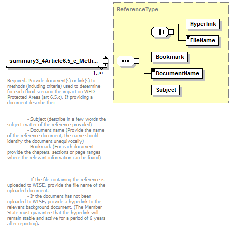 |
||||||||
| namespace | http://water.eionet.europa.eu/schemas/dir200760ec | ||||||||
| type | ReferenceType | ||||||||
| properties |
|
||||||||
| children | Hyperlink FileName Bookmark DocumentName Subject | ||||||||
| annotation |
|
||||||||
| source | <xs:element name="summary3_4Article6.5_c_MethodWfdProtectedAreasReference" type="fd:ReferenceType" maxOccurs="unbounded"> <xs:annotation> <xs:documentation>Required. Provide document(s) or link(s) to methods (including criteria) used to determine for each flood scenario the impact on WFD Protected Areas (art 6.5.c). If providing a document describe the: - Subject (describe in a few words the subject matter of the reference provided) - Document name (Provide the name of the reference document, the name should identify the document unequivocally) - Bookmark (For each document provide the chapters, sections or page ranges where the relevant information can be found) - If the file containing the reference is uploaded to WISE, provide the file name of the uploaded document. - If the document has not been uploaded to WISE, provide a hyperlink to the relevant background document. (The Member State must guarantee that the hyperlink will remain stable and active for a period of 6 years after reporting).</xs:documentation> </xs:annotation> </xs:element> |
element Summary3/summary3_5Article6.5_d_MethodOtherInformationReference
| diagram | 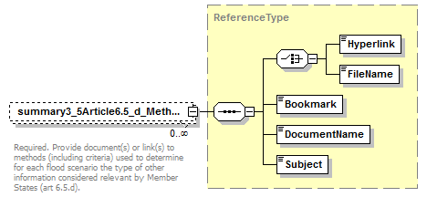 |
||||||||
| namespace | http://water.eionet.europa.eu/schemas/dir200760ec | ||||||||
| type | ReferenceType | ||||||||
| properties |
|
||||||||
| children | Hyperlink FileName Bookmark DocumentName Subject | ||||||||
| annotation |
|
||||||||
| source | <xs:element name="summary3_5Article6.5_d_MethodOtherInformationReference" type="fd:ReferenceType" minOccurs="0" maxOccurs="unbounded"> <xs:annotation> <xs:documentation>Required. Provide document(s) or link(s) to methods (including criteria) used to determine for each flood scenario the type of other information considered relevant by Member States (art 6.5.d). </xs:documentation> </xs:annotation> </xs:element> |
complexType Summary4
| diagram | 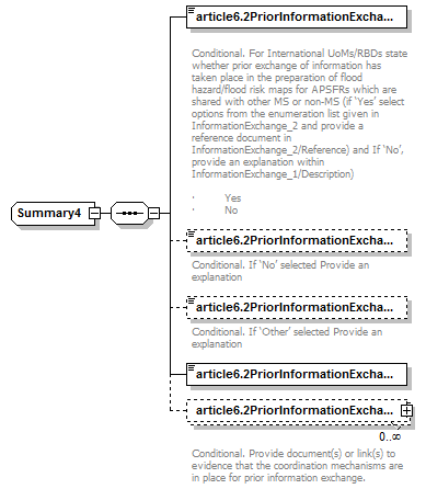 |
||
| namespace | http://water.eionet.europa.eu/schemas/dir200760ec | ||
| children | article6.2PriorInformationExchangeOccurred article6.2PriorInformationExchangeDescription article6.2PriorInformationExchange article6.2PriorInformationExchangeOtherDescription article6.2PriorInformationExchangeReference | ||
| used by |
|
||
| source | <xs:complexType name="Summary4"> <xs:sequence> <xs:element name="article6.2PriorInformationExchangeOccurred" type="fd:YesNoCode"> <xs:annotation> <xs:documentation> Conditional. For International UoMs/RBDs state whether prior exchange of information has taken place in the preparation of flood hazard/flood risk maps for APSFRs which are shared with other MS or non-MS (if ‘Yes’ select options from the enumeration list given in InformationExchange_2 and provide a reference document in InformationExchange_2/Reference) and If ‘No’, provide an explanation within InformationExchange_1/Description) · Yes · No</xs:documentation> </xs:annotation> </xs:element> <xs:element name="article6.2PriorInformationExchangeDescription" type="fd:String1000Type" minOccurs="0"> <xs:annotation> <xs:documentation>Conditional. If ‘No’ selected Provide an explanation</xs:documentation> </xs:annotation> </xs:element> <xs:element name="article6.2PriorInformationExchange" type="fd:YesNoCode" minOccurs="0"> <xs:annotation> <xs:documentation>Conditional. If ‘Other’ selected Provide an explanation</xs:documentation> </xs:annotation> </xs:element> <xs:element name="article6.2PriorInformationExchangeOtherDescription" type="fd:String1000Type"/> <xs:element name="article6.2PriorInformationExchangeReference" type="fd:ReferenceType" minOccurs="0" maxOccurs="unbounded"> <xs:annotation> <xs:documentation>Conditional. Provide document(s) or link(s) to evidence that the coordination mechanisms are in place for prior information exchange. </xs:documentation> </xs:annotation> </xs:element> </xs:sequence> </xs:complexType> |
element Summary4/article6.2PriorInformationExchangeOccurred
| diagram | 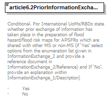 |
||||||||||||
| namespace | http://water.eionet.europa.eu/schemas/dir200760ec | ||||||||||||
| type | YesNoCode | ||||||||||||
| properties |
|
||||||||||||
| facets |
|
||||||||||||
| annotation |
|
||||||||||||
| source | <xs:element name="article6.2PriorInformationExchangeOccurred" type="fd:YesNoCode"> <xs:annotation> <xs:documentation> Conditional. For International UoMs/RBDs state whether prior exchange of information has taken place in the preparation of flood hazard/flood risk maps for APSFRs which are shared with other MS or non-MS (if ‘Yes’ select options from the enumeration list given in InformationExchange_2 and provide a reference document in InformationExchange_2/Reference) and If ‘No’, provide an explanation within InformationExchange_1/Description) · Yes · No</xs:documentation> </xs:annotation> </xs:element> |
element Summary4/article6.2PriorInformationExchangeDescription
| diagram | 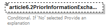 |
|||||||||
| namespace | http://water.eionet.europa.eu/schemas/dir200760ec | |||||||||
| type | String1000Type | |||||||||
| properties |
|
|||||||||
| facets |
|
|||||||||
| annotation |
|
|||||||||
| source | <xs:element name="article6.2PriorInformationExchangeDescription" type="fd:String1000Type" minOccurs="0"> <xs:annotation> <xs:documentation>Conditional. If ‘No’ selected Provide an explanation</xs:documentation> </xs:annotation> </xs:element> |
element Summary4/article6.2PriorInformationExchange
| diagram | 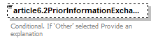 |
||||||||||||
| namespace | http://water.eionet.europa.eu/schemas/dir200760ec | ||||||||||||
| type | YesNoCode | ||||||||||||
| properties |
|
||||||||||||
| facets |
|
||||||||||||
| annotation |
|
||||||||||||
| source | <xs:element name="article6.2PriorInformationExchange" type="fd:YesNoCode" minOccurs="0"> <xs:annotation> <xs:documentation>Conditional. If ‘Other’ selected Provide an explanation</xs:documentation> </xs:annotation> </xs:element> |
element Summary4/article6.2PriorInformationExchangeOtherDescription
| diagram | ||||||||||
| namespace | http://water.eionet.europa.eu/schemas/dir200760ec | |||||||||
| type | String1000Type | |||||||||
| properties |
|
|||||||||
| facets |
|
|||||||||
| source | <xs:element name="article6.2PriorInformationExchangeOtherDescription" type="fd:String1000Type"/> |
element Summary4/article6.2PriorInformationExchangeReference
| diagram | 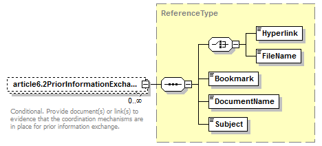 |
||||||||
| namespace | http://water.eionet.europa.eu/schemas/dir200760ec | ||||||||
| type | ReferenceType | ||||||||
| properties |
|
||||||||
| children | Hyperlink FileName Bookmark DocumentName Subject | ||||||||
| annotation |
|
||||||||
| source | <xs:element name="article6.2PriorInformationExchangeReference" type="fd:ReferenceType" minOccurs="0" maxOccurs="unbounded"> <xs:annotation> <xs:documentation>Conditional. Provide document(s) or link(s) to evidence that the coordination mechanisms are in place for prior information exchange. </xs:documentation> </xs:annotation> </xs:element> |
complexType Summary5
| diagram | 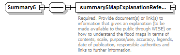 |
||
| namespace | http://water.eionet.europa.eu/schemas/dir200760ec | ||
| children | summary5MapExplanationReference | ||
| used by |
|
||
| source | <xs:complexType name="Summary5"> <xs:sequence> <xs:element name="summary5MapExplanationReference" type="fd:ReferenceType"> <xs:annotation> <xs:documentation>Required. Provide document(s) or link(s) to information that gives an explanation (to be made available to the public through WISE) on how to understand the flood maps in terms of contents, scale, purpose/use, accuracy, legends, date of publication, responsible authorities and links to further information. </xs:documentation> </xs:annotation> </xs:element> </xs:sequence> </xs:complexType> |
element Summary5/summary5MapExplanationReference
| diagram | 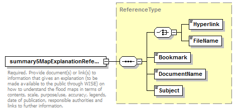 |
||||
| namespace | http://water.eionet.europa.eu/schemas/dir200760ec | ||||
| type | ReferenceType | ||||
| properties |
|
||||
| children | Hyperlink FileName Bookmark DocumentName Subject | ||||
| annotation |
|
||||
| source | <xs:element name="summary5MapExplanationReference" type="fd:ReferenceType"> <xs:annotation> <xs:documentation>Required. Provide document(s) or link(s) to information that gives an explanation (to be made available to the public through WISE) on how to understand the flood maps in terms of contents, scale, purpose/use, accuracy, legends, date of publication, responsible authorities and links to further information. </xs:documentation> </xs:annotation> </xs:element> |
complexType TypeIEDInstallations
| diagram | 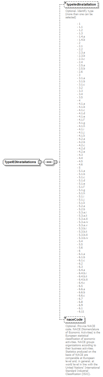 |
||
| namespace | http://water.eionet.europa.eu/schemas/dir200760ec | ||
| children | typeIedInstallation naceCode | ||
| used by |
|
||
| source | <xs:complexType name="TypeIEDInstallations"> <xs:sequence> <xs:element name="typeIedInstallation" type="fd:NumberNonNegativeIntegerType" minOccurs="0"> <xs:annotation> <xs:documentation>Optional. Identify type (more than one can be selected) - 1 - 1.1 - 1.2 - 1.3 - 1.4.a - 1.4.b - 2 - 2.1 - 2.2 - 2.3.a - 2.3.b - 2.3.c - 2.4 - 2.5.a - 2.5.b - 2.6 - 3 - 3.1.a - 3.1.b - 3.1.c - 3.2 - 3.3 - 3.4 - 3.5 - 4 - 4.1.a - 4.1.b - 4.1.c - 4.1.d - 4.1.e - 4.1.f - 4.1.g - 4.1.h - 4.1.i - 4.1.j - 4.1.k - 4.2.a - 4.2.b - 4.2.c - 4.2.d - 4.2.e - 4.3 - 4.4 - 4.5 - 4.6 - 5 - 5.1.a - 5.1.b - 5.1.c - 5.1.d - 5.1.e - 5.1.f - 5.1.g - 5.1.h - 5.1.i - 5.1.j - 5.1.k - 5.2.a - 5.2.b - 5.3.a.i - 5.3.a.ii - 5.3.a.iii - 5.3.a.iv - 5.3.a.v - 5.3.b.i - 5.3.b.ii - 5.3.b.iii - 5.3.b.iv - 5.4 - 5.5 - 5.6 - 6 - 6.1.a - 6.1.b - 6.1.c - 6.2 - 6.3 - 6.4.a - 6.4.b.i - 6.4.b.ii - 6.4.b.iii - 6.4.c - 6.5 - 6.6.a - 6.6.b - 6.6.c - 6.7 - 6.8 - 6.9 - 6.1 - 6.11</xs:documentation> </xs:annotation> </xs:element> <xs:element name="naceCode" type="fd:String250Type" minOccurs="0"> <xs:annotation> <xs:documentation>Optional. Provice NACE code. NACE (Nomenclature of Economic Activities) is the European statistical classification of economic activities. NACE groups organizations according to their business activities. Statistics produced on the basis of NACE are comparable at European level and, in general, at world level in line with the United Nations' International Standard Industrial Classification (ISIC).</xs:documentation> </xs:annotation> </xs:element> </xs:sequence> </xs:complexType> |
element TypeIEDInstallations/typeIedInstallation
| diagram | 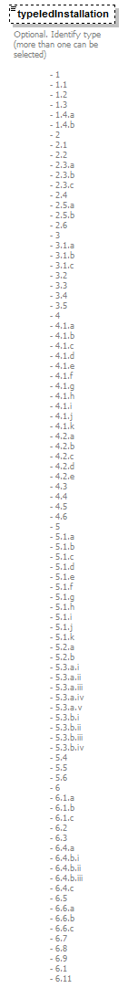 |
||||||||
| namespace | http://water.eionet.europa.eu/schemas/dir200760ec | ||||||||
| type | NumberNonNegativeIntegerType | ||||||||
| properties |
|
||||||||
| annotation |
|
||||||||
| source | <xs:element name="typeIedInstallation" type="fd:NumberNonNegativeIntegerType" minOccurs="0"> <xs:annotation> <xs:documentation>Optional. Identify type (more than one can be selected) - 1 - 1.1 - 1.2 - 1.3 - 1.4.a - 1.4.b - 2 - 2.1 - 2.2 - 2.3.a - 2.3.b - 2.3.c - 2.4 - 2.5.a - 2.5.b - 2.6 - 3 - 3.1.a - 3.1.b - 3.1.c - 3.2 - 3.3 - 3.4 - 3.5 - 4 - 4.1.a - 4.1.b - 4.1.c - 4.1.d - 4.1.e - 4.1.f - 4.1.g - 4.1.h - 4.1.i - 4.1.j - 4.1.k - 4.2.a - 4.2.b - 4.2.c - 4.2.d - 4.2.e - 4.3 - 4.4 - 4.5 - 4.6 - 5 - 5.1.a - 5.1.b - 5.1.c - 5.1.d - 5.1.e - 5.1.f - 5.1.g - 5.1.h - 5.1.i - 5.1.j - 5.1.k - 5.2.a - 5.2.b - 5.3.a.i - 5.3.a.ii - 5.3.a.iii - 5.3.a.iv - 5.3.a.v - 5.3.b.i - 5.3.b.ii - 5.3.b.iii - 5.3.b.iv - 5.4 - 5.5 - 5.6 - 6 - 6.1.a - 6.1.b - 6.1.c - 6.2 - 6.3 - 6.4.a - 6.4.b.i - 6.4.b.ii - 6.4.b.iii - 6.4.c - 6.5 - 6.6.a - 6.6.b - 6.6.c - 6.7 - 6.8 - 6.9 - 6.1 - 6.11</xs:documentation> </xs:annotation> </xs:element> |
element TypeIEDInstallations/naceCode
| diagram |  |
|||||||||
| namespace | http://water.eionet.europa.eu/schemas/dir200760ec | |||||||||
| type | String250Type | |||||||||
| properties |
|
|||||||||
| facets |
|
|||||||||
| annotation |
|
|||||||||
| source | <xs:element name="naceCode" type="fd:String250Type" minOccurs="0"> <xs:annotation> <xs:documentation>Optional. Provice NACE code. NACE (Nomenclature of Economic Activities) is the European statistical classification of economic activities. NACE groups organizations according to their business activities. Statistics produced on the basis of NACE are comparable at European level and, in general, at world level in line with the United Nations' International Standard Industrial Classification (ISIC).</xs:documentation> </xs:annotation> </xs:element> |
complexType TypeofFloods
| diagram | 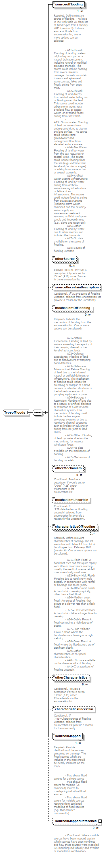 |
||
| namespace | http://water.eionet.europa.eu/schemas/dir200760ec | ||
| children | sourceofFlooding otherSource sourceUncertainDescription mechanismOfFlooding otherMechanism mechanismUncertain characteristicsOfFlooding otherCharacteristics characteristicsUncertain sourcesMapped sourcesMappedReference | ||
| used by |
|
||
| source | <xs:complexType name="TypeofFloods"> <xs:sequence> <xs:element name="sourceofFlooding" type="fd:SourceofFlooding_Enum" maxOccurs="unbounded"> <xs:annotation> <xs:documentation>Required. Define relevant source of flooding. The list is in line with table A1 from list of flood types from February 2011 (version 6). Indicate source of floods from enumeration list, one or more options can be selected: - A11=Fluvial: Flooding of land by waters originating from part of a natural drainage system, including natural or modified drainage channels. This source could include flooding from rivers, streams, drainage channels, mountain torrents and ephemeral watercourses, lakes and floods arising from snow melt. - A12=Pluvial: Flooding of land directly from rainfall water falling on, or flowing over, the land. This source could include urban storm water, rural overland flow or excess water, or overland floods arising from snowmelt. - A13=Groundwater: Flooding of land by waters from underground rising to above the land surface. This source could include rising groundwater and underground flow from elevated surface waters. - A14=Sea Water: Flooding of land by water from the sea, estuaries or coastal lakes. This source could include flooding from the sea (e.g., extreme tidal level and / or storm surges) or arising from wave action or coastal tsunamis. - A15=Artificial Water-Bearing Infrastructure: Flooding of land by water arising from artificial, water-bearing infrastructure or failure of such infrastructure. This source could include flooding arising from sewerage systems (including storm water, combined and foul sewers), water supply and wastewater treatment systems, artificial navigation canals and impoundments (e.g., dams and reservoirs). - A16=Other: Flooding of land by water due to other sources, can include other tsunamis. - A17=No data available on the source of flooding. - A18=Source of flooding uncertain</xs:documentation> </xs:annotation> </xs:element> <xs:element name="otherSource" type="fd:String1000Type" minOccurs="0" maxOccurs="unbounded"> <xs:annotation> <xs:documentation>CONDITIONAL. Provide a description if type is set to 'Other' (A16) under Source in the enumeration list</xs:documentation> </xs:annotation> </xs:element> <xs:element name="sourceUncertainDescription" type="fd:String1000Type" minOccurs="0"> <xs:annotation> <xs:documentation>Conditional. If ‘A18=Source of flooding uncertain’ selected from enumeration list provide a reason for the uncertainty</xs:documentation> </xs:annotation> </xs:element> <xs:element name="mechanismOfFlooding" type="fd:MechanismofFlooding_Enum" minOccurs="0" maxOccurs="unbounded"> <xs:annotation> <xs:documentation>Required. Indicate the mechanism of flooding from the enumeration list. One or more options can be selected: - A21=Natural Exceedance: Flooding of land by waters exceeding the capacity of their carrying channel or the level of adjacent lands. - A22=Defence Exceedance: Flooding of land due to floodwaters overtopping flood defences. - A23=Defence or Infrastructural Failure:Flooding of land due to the failure of natural or artificial defences or infrastructure. This mechanism of flooding could include the breaching or collapse of a flood defence or retention structure, or the failure in operation of pumping equipment or gates. - A24=Blockage / Restriction: Flooding of land due to a natural or artificial blockage or restriction of a conveyance channel or system. This mechanism of flooding could include the blockage of sewerage systems or due to restrictive channel structures such as bridges or culverts or arising from ice jams or land slides. - A25=Other: Flooding of land by water due to other mechanisms, for instance windsetup floods. - A26=No data available on the mechanism of flooding - A27=Mechanism of flooding uncertain</xs:documentation> </xs:annotation> </xs:element> <xs:element name="otherMechanism" type="fd:String1000Type" minOccurs="0" maxOccurs="unbounded"> <xs:annotation> <xs:documentation>Conditional. Provide a description if type is set to 'Other' (A25) under Mechanism in the enumeration list</xs:documentation> </xs:annotation> </xs:element> <xs:element name="mechanismUncertain" type="fd:String1000Type" minOccurs="0"> <xs:annotation> <xs:documentation>Conditional. If ‘A27=Mechanism of flooding uncertain’ selected from enumeration list provide a reason for the uncertainty.</xs:documentation> </xs:annotation> </xs:element> <xs:element name="characteristicsOfFlooding" type="fd:CharacteristicsofFlooding_Enum" minOccurs="0" maxOccurs="unbounded"> <xs:annotation> <xs:documentation>Required. Define relevant characteristics of flooding. The list are in line with table A3 from list of flood types from February 2011 (version 6). One or more options can be selected. - A31=Flash Flood: A flood that rises and falls quite rapidly with little or no advance warning, usually the result of intense rainfall over a relatively small area. - A32=Snow Melt Flood: Flooding due to rapid snow melt, possibly in combination with rainfall or blockage due to ice jams. - A33=Other rapid onset: A flood which develops quickly, other than a flash flood . - A34=Medium onset flood: An onset of flooding, that occurs at a slower rate than a flash flood. - A35=Slow onset flood: A flood which takes a longer time to develop. - A36=Debris Flow: A flood conveying a high degree of debris. - A37=High Velocity Flow: A flood where the floodwaters are flowing at a high velocity. - A38=Deep Flood: A flood where the floodwaters are of significant depth. - A39=Other characteristics, or no special characteristics. - A40= No data available on the characteristics of flooding. - A41=Characteristics of flooding uncertain.</xs:documentation> </xs:annotation> </xs:element> <xs:element name="otherCharacteristics" type="fd:String1000Type" minOccurs="0" maxOccurs="unbounded"> <xs:annotation> <xs:documentation>Conditional. Provide a description if type is set to 'Other' (A39) under Characteristics in the enumeration list</xs:documentation> </xs:annotation> </xs:element> <xs:element name="characteristicsUncertain" type="fd:String1000Type" minOccurs="0"> <xs:annotation> <xs:documentation>Conditional. If ‘A41=Characteristics of flooding uncertain’ selected from enumeration list provide a reason for the uncertainty</xs:documentation> </xs:annotation> </xs:element> <xs:element name="sourcesMapped" type="fd:FloodSourcesMapped_Enum" maxOccurs="unbounded"> <xs:annotation> <xs:documentation>Required. Provide clarification of the sources presented on the map. The flood sources which are included in the map should be clearly indicated on the map. - Map shows flood extents for a single source - Map shows flood extent for multiple (i.e. combined) sources by overlapping individual flood sources - Map shows flood extent for multiple sources resulting from combined modelling of flood sources (e.g. that occurred concurrently)</xs:documentation> </xs:annotation> </xs:element> <xs:element name="sourcesMappedReference" type="fd:ReferenceType" minOccurs="0" maxOccurs="unbounded"> <xs:annotation> <xs:documentation> - Conditional. Where multiple sources have been mapped explain which sources have been combined and how these sources were modelled i.e. modelling individually and overlain or modelled in combination. </xs:documentation> </xs:annotation> </xs:element> </xs:sequence> </xs:complexType> |
element TypeofFloods/sourceofFlooding
| diagram | 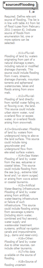 |
|||||||||||||||||||||||||||
| namespace | http://water.eionet.europa.eu/schemas/dir200760ec | |||||||||||||||||||||||||||
| type | SourceofFlooding_Enum | |||||||||||||||||||||||||||
| properties |
|
|||||||||||||||||||||||||||
| facets |
|
|||||||||||||||||||||||||||
| annotation |
|
|||||||||||||||||||||||||||
| source | <xs:element name="sourceofFlooding" type="fd:SourceofFlooding_Enum" maxOccurs="unbounded"> <xs:annotation> <xs:documentation>Required. Define relevant source of flooding. The list is in line with table A1 from list of flood types from February 2011 (version 6). Indicate source of floods from enumeration list, one or more options can be selected: - A11=Fluvial: Flooding of land by waters originating from part of a natural drainage system, including natural or modified drainage channels. This source could include flooding from rivers, streams, drainage channels, mountain torrents and ephemeral watercourses, lakes and floods arising from snow melt. - A12=Pluvial: Flooding of land directly from rainfall water falling on, or flowing over, the land. This source could include urban storm water, rural overland flow or excess water, or overland floods arising from snowmelt. - A13=Groundwater: Flooding of land by waters from underground rising to above the land surface. This source could include rising groundwater and underground flow from elevated surface waters. - A14=Sea Water: Flooding of land by water from the sea, estuaries or coastal lakes. This source could include flooding from the sea (e.g., extreme tidal level and / or storm surges) or arising from wave action or coastal tsunamis. - A15=Artificial Water-Bearing Infrastructure: Flooding of land by water arising from artificial, water-bearing infrastructure or failure of such infrastructure. This source could include flooding arising from sewerage systems (including storm water, combined and foul sewers), water supply and wastewater treatment systems, artificial navigation canals and impoundments (e.g., dams and reservoirs). - A16=Other: Flooding of land by water due to other sources, can include other tsunamis. - A17=No data available on the source of flooding. - A18=Source of flooding uncertain</xs:documentation> </xs:annotation> </xs:element> |
element TypeofFloods/otherSource
| diagram | 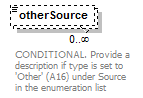 |
|||||||||
| namespace | http://water.eionet.europa.eu/schemas/dir200760ec | |||||||||
| type | String1000Type | |||||||||
| properties |
|
|||||||||
| facets |
|
|||||||||
| annotation |
|
|||||||||
| source | <xs:element name="otherSource" type="fd:String1000Type" minOccurs="0" maxOccurs="unbounded"> <xs:annotation> <xs:documentation>CONDITIONAL. Provide a description if type is set to 'Other' (A16) under Source in the enumeration list</xs:documentation> </xs:annotation> </xs:element> |
element TypeofFloods/sourceUncertainDescription
| diagram | 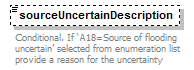 |
|||||||||
| namespace | http://water.eionet.europa.eu/schemas/dir200760ec | |||||||||
| type | String1000Type | |||||||||
| properties |
|
|||||||||
| facets |
|
|||||||||
| annotation |
|
|||||||||
| source | <xs:element name="sourceUncertainDescription" type="fd:String1000Type" minOccurs="0"> <xs:annotation> <xs:documentation>Conditional. If ‘A18=Source of flooding uncertain’ selected from enumeration list provide a reason for the uncertainty</xs:documentation> </xs:annotation> </xs:element> |
element TypeofFloods/mechanismOfFlooding
| diagram | 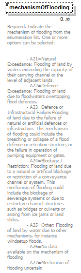 |
||||||||||||||||||||||||
| namespace | http://water.eionet.europa.eu/schemas/dir200760ec | ||||||||||||||||||||||||
| type | MechanismofFlooding_Enum | ||||||||||||||||||||||||
| properties |
|
||||||||||||||||||||||||
| facets |
|
||||||||||||||||||||||||
| annotation |
|
||||||||||||||||||||||||
| source | <xs:element name="mechanismOfFlooding" type="fd:MechanismofFlooding_Enum" minOccurs="0" maxOccurs="unbounded"> <xs:annotation> <xs:documentation>Required. Indicate the mechanism of flooding from the enumeration list. One or more options can be selected: - A21=Natural Exceedance: Flooding of land by waters exceeding the capacity of their carrying channel or the level of adjacent lands. - A22=Defence Exceedance: Flooding of land due to floodwaters overtopping flood defences. - A23=Defence or Infrastructural Failure:Flooding of land due to the failure of natural or artificial defences or infrastructure. This mechanism of flooding could include the breaching or collapse of a flood defence or retention structure, or the failure in operation of pumping equipment or gates. - A24=Blockage / Restriction: Flooding of land due to a natural or artificial blockage or restriction of a conveyance channel or system. This mechanism of flooding could include the blockage of sewerage systems or due to restrictive channel structures such as bridges or culverts or arising from ice jams or land slides. - A25=Other: Flooding of land by water due to other mechanisms, for instance windsetup floods. - A26=No data available on the mechanism of flooding - A27=Mechanism of flooding uncertain</xs:documentation> </xs:annotation> </xs:element> |
element TypeofFloods/otherMechanism
| diagram |  |
|||||||||
| namespace | http://water.eionet.europa.eu/schemas/dir200760ec | |||||||||
| type | String1000Type | |||||||||
| properties |
|
|||||||||
| facets |
|
|||||||||
| annotation |
|
|||||||||
| source | <xs:element name="otherMechanism" type="fd:String1000Type" minOccurs="0" maxOccurs="unbounded"> <xs:annotation> <xs:documentation>Conditional. Provide a description if type is set to 'Other' (A25) under Mechanism in the enumeration list</xs:documentation> </xs:annotation> </xs:element> |
element TypeofFloods/mechanismUncertain
| diagram | 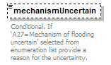 |
|||||||||
| namespace | http://water.eionet.europa.eu/schemas/dir200760ec | |||||||||
| type | String1000Type | |||||||||
| properties |
|
|||||||||
| facets |
|
|||||||||
| annotation |
|
|||||||||
| source | <xs:element name="mechanismUncertain" type="fd:String1000Type" minOccurs="0"> <xs:annotation> <xs:documentation>Conditional. If ‘A27=Mechanism of flooding uncertain’ selected from enumeration list provide a reason for the uncertainty.</xs:documentation> </xs:annotation> </xs:element> |
element TypeofFloods/characteristicsOfFlooding
| diagram | 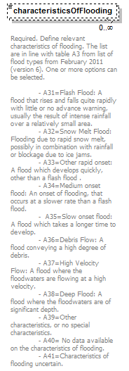 |
||||||||||||||||||||||||||||||||||||
| namespace | http://water.eionet.europa.eu/schemas/dir200760ec | ||||||||||||||||||||||||||||||||||||
| type | CharacteristicsofFlooding_Enum | ||||||||||||||||||||||||||||||||||||
| properties |
|
||||||||||||||||||||||||||||||||||||
| facets |
|
||||||||||||||||||||||||||||||||||||
| annotation |
|
||||||||||||||||||||||||||||||||||||
| source | <xs:element name="characteristicsOfFlooding" type="fd:CharacteristicsofFlooding_Enum" minOccurs="0" maxOccurs="unbounded"> <xs:annotation> <xs:documentation>Required. Define relevant characteristics of flooding. The list are in line with table A3 from list of flood types from February 2011 (version 6). One or more options can be selected. - A31=Flash Flood: A flood that rises and falls quite rapidly with little or no advance warning, usually the result of intense rainfall over a relatively small area. - A32=Snow Melt Flood: Flooding due to rapid snow melt, possibly in combination with rainfall or blockage due to ice jams. - A33=Other rapid onset: A flood which develops quickly, other than a flash flood . - A34=Medium onset flood: An onset of flooding, that occurs at a slower rate than a flash flood. - A35=Slow onset flood: A flood which takes a longer time to develop. - A36=Debris Flow: A flood conveying a high degree of debris. - A37=High Velocity Flow: A flood where the floodwaters are flowing at a high velocity. - A38=Deep Flood: A flood where the floodwaters are of significant depth. - A39=Other characteristics, or no special characteristics. - A40= No data available on the characteristics of flooding. - A41=Characteristics of flooding uncertain.</xs:documentation> </xs:annotation> </xs:element> |
element TypeofFloods/otherCharacteristics
| diagram |  |
|||||||||
| namespace | http://water.eionet.europa.eu/schemas/dir200760ec | |||||||||
| type | String1000Type | |||||||||
| properties |
|
|||||||||
| facets |
|
|||||||||
| annotation |
|
|||||||||
| source | <xs:element name="otherCharacteristics" type="fd:String1000Type" minOccurs="0" maxOccurs="unbounded"> <xs:annotation> <xs:documentation>Conditional. Provide a description if type is set to 'Other' (A39) under Characteristics in the enumeration list</xs:documentation> </xs:annotation> </xs:element> |
element TypeofFloods/characteristicsUncertain
| diagram |  |
|||||||||
| namespace | http://water.eionet.europa.eu/schemas/dir200760ec | |||||||||
| type | String1000Type | |||||||||
| properties |
|
|||||||||
| facets |
|
|||||||||
| annotation |
|
|||||||||
| source | <xs:element name="characteristicsUncertain" type="fd:String1000Type" minOccurs="0"> <xs:annotation> <xs:documentation>Conditional. If ‘A41=Characteristics of flooding uncertain’ selected from enumeration list provide a reason for the uncertainty</xs:documentation> </xs:annotation> </xs:element> |
element TypeofFloods/sourcesMapped
| diagram | 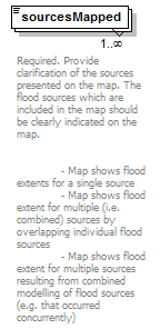 |
||||||||||||
| namespace | http://water.eionet.europa.eu/schemas/dir200760ec | ||||||||||||
| type | FloodSourcesMapped_Enum | ||||||||||||
| properties |
|
||||||||||||
| facets |
|
||||||||||||
| annotation |
|
||||||||||||
| source | <xs:element name="sourcesMapped" type="fd:FloodSourcesMapped_Enum" maxOccurs="unbounded"> <xs:annotation> <xs:documentation>Required. Provide clarification of the sources presented on the map. The flood sources which are included in the map should be clearly indicated on the map. - Map shows flood extents for a single source - Map shows flood extent for multiple (i.e. combined) sources by overlapping individual flood sources - Map shows flood extent for multiple sources resulting from combined modelling of flood sources (e.g. that occurred concurrently)</xs:documentation> </xs:annotation> </xs:element> |
element TypeofFloods/sourcesMappedReference
| diagram |  |
||||||||
| namespace | http://water.eionet.europa.eu/schemas/dir200760ec | ||||||||
| type | ReferenceType | ||||||||
| properties |
|
||||||||
| children | Hyperlink FileName Bookmark DocumentName Subject | ||||||||
| annotation |
|
||||||||
| source | <xs:element name="sourcesMappedReference" type="fd:ReferenceType" minOccurs="0" maxOccurs="unbounded"> <xs:annotation> <xs:documentation> - Conditional. Where multiple sources have been mapped explain which sources have been combined and how these sources were modelled i.e. modelling individually and overlain or modelled in combination. </xs:documentation> </xs:annotation> </xs:element> |
complexType ReferenceType
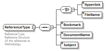
element ReferenceType/Hyperlink
| diagram | |||||||||||||
| namespace | http://water.eionet.europa.eu/schemas/dir200760ec/fdcommon | ||||||||||||
| type | URLType | ||||||||||||
| properties |
|
||||||||||||
| facets |
|
||||||||||||
| source | <xs:element name="Hyperlink" type="URLType"/> |
element ReferenceType/FileName
| diagram | ||||||||||
| namespace | http://water.eionet.europa.eu/schemas/dir200760ec/fdcommon | |||||||||
| type | String50Type | |||||||||
| properties |
|
|||||||||
| facets |
|
|||||||||
| source | <xs:element name="FileName" type="String50Type"/> |
element ReferenceType/Bookmark
| diagram | ||||||||||
| namespace | http://water.eionet.europa.eu/schemas/dir200760ec/fdcommon | |||||||||
| type | String50Type | |||||||||
| properties |
|
|||||||||
| facets |
|
|||||||||
| source | <xs:element name="Bookmark" type="String50Type"/> |
element ReferenceType/DocumentName
| diagram | ||||||||||
| namespace | http://water.eionet.europa.eu/schemas/dir200760ec/fdcommon | |||||||||
| type | String250Type | |||||||||
| properties |
|
|||||||||
| facets |
|
|||||||||
| source | <xs:element name="DocumentName" type="String250Type"/> |
element ReferenceType/Subject
| diagram | ||||||||||
| namespace | http://water.eionet.europa.eu/schemas/dir200760ec/fdcommon | |||||||||
| type | String250Type | |||||||||
| properties |
|
|||||||||
| facets |
|
|||||||||
| source | <xs:element name="Subject" type="String250Type"/> |
simpleType Article_6.6_Justification_Enum
| namespace | http://water.eionet.europa.eu/schemas/dir200760ec/fdcommon | |||||||||||||||
| type | restriction of xs:string | |||||||||||||||
| used by |
|
|||||||||||||||
| facets |
|
|||||||||||||||
| source | <xs:simpleType name="Article_6.6_Justification_Enum"> <xs:restriction base="xs:string"> <xs:enumeration value="Other justification (please specify)"/> <xs:enumeration value="Prevention of damage and damge potential through legal regulations for use (e.g. for the embankment foreland)"/> <xs:enumeration value="Risk of failure of existing defences assessed"/> <xs:enumeration value="Risk of overtopping of existing flood defences assessed"/> </xs:restriction> </xs:simpleType> |
simpleType Article_6.7_Justification_Enum
| namespace | http://water.eionet.europa.eu/schemas/dir200760ec/fdcommon | ||||||||||||||||||
| type | restriction of xs:string | ||||||||||||||||||
| used by |
|
||||||||||||||||||
| facets |
|
||||||||||||||||||
| source | <xs:simpleType name="Article_6.7_Justification_Enum"> <xs:restriction base="xs:string"> <xs:enumeration value="Groundwater is considered as a contributing source rather than a main source of flooding"/> <xs:enumeration value="It is difficult to distinguish the impact of groundwater flooding from other sources of flooding"/> <xs:enumeration value="Only low probability groundwater flooding is assessed to be a hazardous risk"/> <xs:enumeration value="Other justification"/> <xs:enumeration value="There is limited information or historical records on groundwater flooding"/> </xs:restriction> </xs:simpleType> |
simpleType CategoryFloods_Enum
| namespace | http://water.eionet.europa.eu/schemas/dir200760ec/fdcommon | |||||||||
| type | restriction of xs:string | |||||||||
| facets |
|
|||||||||
| annotation |
|
|||||||||
| source | <xs:simpleType name="CategoryFloods_Enum"> <xs:annotation> <xs:documentation>Can be past flood (past) or potential future flood (future)</xs:documentation> </xs:annotation> <xs:restriction base="xs:string"> <xs:enumeration value="Past flood"/> <xs:enumeration value="Potential future floods"/> </xs:restriction> </xs:simpleType> |
simpleType CharacteristicsofFlooding_Enum
| namespace | http://water.eionet.europa.eu/schemas/dir200760ec/fdcommon | ||||||||||||||||||||||||||||||||||||
| type | restriction of xs:string | ||||||||||||||||||||||||||||||||||||
| used by |
|
||||||||||||||||||||||||||||||||||||
| facets |
|
||||||||||||||||||||||||||||||||||||
| annotation |
|
||||||||||||||||||||||||||||||||||||
| source | <xs:simpleType name="CharacteristicsofFlooding_Enum"> <xs:annotation> <xs:documentation>Define relevant characteristics of flooding. The list are in line with table A3 from list of flood types from February 2011 (version 6). One or more options can be selected. A31=Flash Flood: A flood that rises and falls quite rapidly with little or no advance warning, usually the result of intense rainfall over a relatively small area. A36=Debris Flow: A flood conveying a high degree of debris. A39=Other characteristics, or no special characteristics. A40=No data available on characteristics of flooding, A41=Characteristics of flooding uncertain.</xs:documentation> </xs:annotation> <xs:restriction base="xs:string"> <xs:enumeration value="A31 - Flash Flood"/> <xs:enumeration value="A32 - Snow Melt Flood"/> <xs:enumeration value="A33 - Other rapid onset"/> <xs:enumeration value="A34 - Medium onset flood"/> <xs:enumeration value="A35 - Slow onset flood"/> <xs:enumeration value="A36 - Debris Flow"/> <xs:enumeration value="A37 - High Velocity Flow"/> <xs:enumeration value="A38 - Deep Flood"/> <xs:enumeration value="A39 - Other"/> <xs:enumeration value="A40 - No data available on characteristics of flooding"/> <xs:enumeration value="A41 - Characteristics of flooding uncertain"/> </xs:restriction> </xs:simpleType> |
simpleType ClimateChange_Enum
| namespace | http://water.eionet.europa.eu/schemas/dir200760ec/fdcommon | |||||||||||||||
| type | restriction of xs:string | |||||||||||||||
| facets |
|
|||||||||||||||
| source | <xs:simpleType name="ClimateChange_Enum"> <xs:restriction base="xs:string"> <xs:enumeration value="No"/> <xs:enumeration value="Yes"/> <xs:enumeration value="Yes but not all sources"/> <xs:enumeration value="Yes but not for all maps"/> </xs:restriction> </xs:simpleType> |
simpleType ConsultationStakeholdersInvolved_Enum
| namespace | http://water.eionet.europa.eu/schemas/dir200760ec/fdcommon | ||||||||||||||||||||||||||||||||||||||||||||||||
| type | restriction of xs:string | ||||||||||||||||||||||||||||||||||||||||||||||||
| facets |
|
||||||||||||||||||||||||||||||||||||||||||||||||
| annotation |
|
||||||||||||||||||||||||||||||||||||||||||||||||
| source | <xs:simpleType name="ConsultationStakeholdersInvolved_Enum"> <xs:annotation> <xs:documentation>Table summarising across MS, the groups of stakeholders who have been actively involved in the development of the FRMPs</xs:documentation> </xs:annotation> <xs:restriction base="xs:string"> <xs:enumeration value="Civil Protection Authorities"/> <xs:enumeration value="Flood Warning/ Defence Authorities"/> <xs:enumeration value="Drainage Authorities"/> <xs:enumeration value="Emergency services"/> <xs:enumeration value="Water supply and sanitation"/> <xs:enumeration value="Agriculture/farmers"/> <xs:enumeration value="Energy/hydropower"/> <xs:enumeration value="Navigation/ports"/> <xs:enumeration value="Fisheries/aquaculture"/> <xs:enumeration value="Industry"/> <xs:enumeration value="NGO's /nature protection"/> <xs:enumeration value="Consumer Groups"/> <xs:enumeration value="Local/Regional authorities"/> <xs:enumeration value="Academia/Research Institutions"/> <xs:enumeration value="Other"/> </xs:restriction> </xs:simpleType> |
simpleType ConsultationStakeholdersInvolvedMechanisms_Enum
| namespace | http://water.eionet.europa.eu/schemas/dir200760ec/fdcommon | |||||||||||||||||||||
| type | restriction of xs:string | |||||||||||||||||||||
| facets |
|
|||||||||||||||||||||
| annotation |
|
|||||||||||||||||||||
| source | <xs:simpleType name="ConsultationStakeholdersInvolvedMechanisms_Enum"> <xs:annotation> <xs:documentation>Table summarising across MS, the mechanisms used to encourage the active involvement of stakeholders in the development of the FRMPs</xs:documentation> </xs:annotation> <xs:restriction base="xs:string"> <xs:enumeration value="Establishment of advisory groups"/> <xs:enumeration value="Provision of information at relevant public exhibitions or providing notices on public sites"/> <xs:enumeration value="Stakeholder involvement in drafting"/> <xs:enumeration value="Formation of alliances"/> <xs:enumeration value="Other outreach activities with opportunities for discussion and dialogue"/> <xs:enumeration value="Other"/> </xs:restriction> </xs:simpleType> |
simpleType CoordinateType
| namespace | http://water.eionet.europa.eu/schemas/dir200760ec/fdcommon | ||||||
| type | restriction of xs:string | ||||||
| facets |
|
||||||
| annotation |
|
||||||
| source | <xs:simpleType name="CoordinateType"> <xs:annotation> <xs:documentation>Format Decimal degrees (-)dd.ddddd</xs:documentation> </xs:annotation> <xs:restriction base="xs:string"> <xs:pattern value="\-{0,1}[0-9]{1,2}\.[0-9]{1,5}"/> </xs:restriction> </xs:simpleType> |
simpleType CoordinationFRMPandRBMP_Enum
| namespace | http://water.eionet.europa.eu/schemas/dir200760ec/fdcommon | |||||||||||||||||||||||||||||||||||||||
| type | restriction of xs:string | |||||||||||||||||||||||||||||||||||||||
| facets |
|
|||||||||||||||||||||||||||||||||||||||
| source | <xs:simpleType name="CoordinationFRMPandRBMP_Enum"> <xs:restriction base="xs:string"> <xs:enumeration value="Integration of FRMP and RBMP into a single document"/> <xs:enumeration value="Joint consultation of draft FRMP and RBMP"/> <xs:enumeration value="Coordination between authorities responsible for developing FRMP and RBMP"/> <xs:enumeration value="The objectives of the FD have been considered in the WFD RBMPs and PoMs"/> <xs:enumeration value="Coordination with the environmental objectives in Art.4 of the WFD"/> <xs:enumeration value="Planning of win-win and no regret measures in FRMP and RBMP have included drought management measures"/> <xs:enumeration value="Planning of win-win and no regret measures in FRMP and RBMP have included Natural water retention and green infrastructure measures"/> <xs:enumeration value="Permitting or consenting of flood risk activities (e.g. dredging, flood defence management) requires prior consideration of WFD objectives and RBMPs"/> <xs:enumeration value="Consistent and compliant application of Article 7 and designation of HMWBs with measures taken under the FD e.g. flood defence infrastructure"/> <xs:enumeration value="The design of new and existing structural measures such as flood defences, storage dams and tidal barriers have been adapted to take into account WFD Environmental Objectives"/> <xs:enumeration value="The use of sustainable drainage systems, such as the construction of wetlands and porous pavements, have been considered to reduce urban flooding and also to contribute to the achievement of WFD objectives"/> <xs:enumeration value="Other"/> </xs:restriction> </xs:simpleType> |
simpleType CountryCode_enum
| namespace | http://water.eionet.europa.eu/schemas/dir200760ec/fdcommon | |||||||||||||||||||||||||||||||||||||||||||||||||||||||||||||||||||||||||||||||||||||||||||||||||||
| type | restriction of xs:string | |||||||||||||||||||||||||||||||||||||||||||||||||||||||||||||||||||||||||||||||||||||||||||||||||||
| used by |
|
|||||||||||||||||||||||||||||||||||||||||||||||||||||||||||||||||||||||||||||||||||||||||||||||||||
| facets |
|
|||||||||||||||||||||||||||||||||||||||||||||||||||||||||||||||||||||||||||||||||||||||||||||||||||
| annotation |
|
|||||||||||||||||||||||||||||||||||||||||||||||||||||||||||||||||||||||||||||||||||||||||||||||||||
| source | <xs:simpleType name="CountryCode_enum"> <xs:annotation> <xs:documentation>Unique 2 character ISO Code for the EU Member States</xs:documentation> </xs:annotation> <xs:restriction base="xs:string"> <xs:enumeration value="AT"/> <xs:enumeration value="BE"/> <xs:enumeration value="BG"/> <xs:enumeration value="CH"/> <xs:enumeration value="CZ"/> <xs:enumeration value="CY"/> <xs:enumeration value="DE"/> <xs:enumeration value="DK"/> <xs:enumeration value="EE"/> <xs:enumeration value="EL"/> <xs:enumeration value="ES"/> <xs:enumeration value="FI"/> <xs:enumeration value="FR"/> <xs:enumeration value="HR"/> <xs:enumeration value="HU"/> <xs:enumeration value="IE"/> <xs:enumeration value="IS"/> <xs:enumeration value="IT"/> <xs:enumeration value="LT"/> <xs:enumeration value="LU"/> <xs:enumeration value="LV"/> <xs:enumeration value="MT"/> <xs:enumeration value="NO"/> <xs:enumeration value="NL"/> <xs:enumeration value="PL"/> <xs:enumeration value="PT"/> <xs:enumeration value="RO"/> <xs:enumeration value="SE"/> <xs:enumeration value="SI"/> <xs:enumeration value="SK"/> <xs:enumeration value="TR"/> <xs:enumeration value="UK"/> </xs:restriction> </xs:simpleType> |
simpleType CriteriaForDeterminationFloodRisk_Enum
| namespace | http://water.eionet.europa.eu/schemas/dir200760ec/fdcommon | |||||||||||||||||||||||||||||||||||||||||||||||||||||||||||||||||||||
| type | restriction of xs:string | |||||||||||||||||||||||||||||||||||||||||||||||||||||||||||||||||||||
| facets |
|
|||||||||||||||||||||||||||||||||||||||||||||||||||||||||||||||||||||
| source | <xs:simpleType name="CriteriaForDeterminationFloodRisk_Enum"> <xs:restriction base="xs:string"> <xs:enumeration value="Flood levels flow velocity depth"/> <xs:enumeration value="Level of damage caused - High"/> <xs:enumeration value="Level of damage caused - Low"/> <xs:enumeration value="Level of damage caused - Medium"/> <xs:enumeration value="Number of buildings affected"/> <xs:enumeration value="Number of inhabitants potentially affected"/> <xs:enumeration value="Number of properties affected"/> <xs:enumeration value="Specific weighting systems defined to assess significance"/> <xs:enumeration value="The presence of contaminated sited in flood prone areas"/> <xs:enumeration value="Number of fatalities"/> <xs:enumeration value="Value of property affected"/> <xs:enumeration value="Area of land covered by water"/> <xs:enumeration value="Economic losses realised"/> <xs:enumeration value="Area of crops destroyed"/> <xs:enumeration value="Damage to the environment and WFD protected areas"/> <xs:enumeration value="Damage to cultural heritage"/> <xs:enumeration value="Recurrence periods"/> <xs:enumeration value="Recurrence periods in combination with land use"/> <xs:enumeration value="Product of velocity and depth"/> <xs:enumeration value="Whether floods have occurred in the past"/> <xs:enumeration value="Predictive modelling"/> <xs:enumeration value="Other"/> </xs:restriction> </xs:simpleType> |
simpleType CriteriaForExclusionOrInclusion_Enum
| namespace | http://water.eionet.europa.eu/schemas/dir200760ec/fdcommon | ||||||||||||||||||||||||||||||||||||||||||||||||
| type | restriction of xs:string | ||||||||||||||||||||||||||||||||||||||||||||||||
| facets |
|
||||||||||||||||||||||||||||||||||||||||||||||||
| source | <xs:simpleType name="CriteriaForExclusionOrInclusion_Enum"> <xs:restriction base="xs:string"> <xs:enumeration value="Changes in land use hace increased vulnerability of the area to flooding"/> <xs:enumeration value="engineered system now in place"/> <xs:enumeration value="Flood defences"/> <xs:enumeration value="Flood defences not in place of not fully"/> <xs:enumeration value="High level of damage expected"/> <xs:enumeration value="Potential risk to cultural heritage"/> <xs:enumeration value="Potential risk to economic activity"/> <xs:enumeration value="Potential risk to human health"/> <xs:enumeration value="Potential risk to the environment"/> <xs:enumeration value="Risk from a particular source is no longer relevant"/> <xs:enumeration value="Other non-structural mitigation measures fully implemented"/> <xs:enumeration value="Drainage systems improved"/> <xs:enumeration value="Low damage expected"/> <xs:enumeration value="Risk not significant based on historic record"/> <xs:enumeration value="Other"/> </xs:restriction> </xs:simpleType> |
simpleType DataConfidentialityClassificationCode_Enum
| namespace | http://water.eionet.europa.eu/schemas/dir200760ec/fdcommon | |||||||||
| type | restriction of xs:string | |||||||||
| used by |
|
|||||||||
| facets |
|
|||||||||
| annotation |
|
|||||||||
| source | <xs:simpleType name="DataConfidentialityClassificationCode_Enum"> <xs:annotation> <xs:documentation>Codes for data security classification: 001 = Unclassified - available for general circulation and public 003 = Confidential - available for EC reporting only </xs:documentation> </xs:annotation> <xs:restriction base="xs:string"> <xs:enumeration value="001 - Unclassified"/> <xs:enumeration value="003 - Confidential"/> </xs:restriction> </xs:simpleType> |
simpleType DateTypeYearType
| namespace | http://water.eionet.europa.eu/schemas/dir200760ec/fdcommon | ||
| type | union of (xs:date, xs:gYear, xs:gYearMonth, NumberExceptionType) | ||
| annotation |
|
||
| source | <xs:simpleType name="DateTypeYearType"> <xs:annotation> <xs:documentation>Both date type yyyy-mm-dd, yyyy-mm and yyyy allowed and the exception types (-9999=Unknown, -8888=Yet to be measured, -7777=Not Applicable)</xs:documentation> </xs:annotation> <xs:union memberTypes="xs:date xs:gYear xs:gYearMonth NumberExceptionType"/> </xs:simpleType> |
simpleType ElementsProbability_Enum
| namespace | http://water.eionet.europa.eu/schemas/dir200760ec/fdcommon | |||||||||||||||||||||
| type | restriction of xs:string | |||||||||||||||||||||
| used by |
|
|||||||||||||||||||||
| facets |
|
|||||||||||||||||||||
| source | <xs:simpleType name="ElementsProbability_Enum"> <xs:restriction base="xs:string"> <xs:enumeration value="Article 6.6 applied"/> <xs:enumeration value="Article 6.7 applied"/> <xs:enumeration value="Flooding Extent"/> <xs:enumeration value="Other"/> <xs:enumeration value="Water depth/level"/> <xs:enumeration value="Water flow/velocity"/> </xs:restriction> </xs:simpleType> |
simpleType FeatureUniqueCodeType
| namespace | http://water.eionet.europa.eu/schemas/dir200760ec/fdcommon | ||||||||||||
| type | restriction of xs:string | ||||||||||||
| used by |
|
||||||||||||
| facets |
|
||||||||||||
| annotation |
|
||||||||||||
| source | <xs:simpleType name="FeatureUniqueCodeType"> <xs:annotation> <xs:documentation>Type for unique code within the Member State for the feature</xs:documentation> </xs:annotation> <xs:restriction base="xs:string"> <xs:minLength value="1"/> <xs:maxLength value="40"/> <xs:whiteSpace value="collapse"/> </xs:restriction> </xs:simpleType> |
simpleType FeatureUniqueCodeTypeEX
| namespace | http://water.eionet.europa.eu/schemas/dir200760ec/fdcommon | ||
| type | union of (FeatureUniqueCodeType, NumberExceptionType) | ||
| annotation |
|
||
| source | <xs:simpleType name="FeatureUniqueCodeTypeEX"> <xs:annotation> <xs:documentation>Type for unique code within the Member State for the feature with options for exceptions. -9999=Unknown, -8888=Yet to be measured, -7777=Not Applicable.</xs:documentation> </xs:annotation> <xs:union memberTypes="FeatureUniqueCodeType NumberExceptionType"/> </xs:simpleType> |
simpleType FeatureUniqueEUCodeType
| namespace | http://water.eionet.europa.eu/schemas/dir200760ec/fdcommon | |||||||||
| type | restriction of xs:string | |||||||||
| used by |
|
|||||||||
| facets |
|
|||||||||
| annotation |
|
|||||||||
| source | <xs:simpleType name="FeatureUniqueEUCodeType"> <xs:annotation> <xs:documentation>Type for EU code, allows up to 42 characters (unique code within MS prefixed with country ISO 2 character code</xs:documentation> </xs:annotation> <xs:restriction base="xs:string"> <xs:minLength value="3"/> <xs:maxLength value="42"/> </xs:restriction> </xs:simpleType> |
simpleType FloodSourcesMapped_Enum
| namespace | http://water.eionet.europa.eu/schemas/dir200760ec/fdcommon | ||||||||||||
| type | restriction of xs:string | ||||||||||||
| used by |
|
||||||||||||
| facets |
|
||||||||||||
| source | <xs:simpleType name="FloodSourcesMapped_Enum"> <xs:restriction base="xs:string"> <xs:enumeration value="Map shows flood extents for a single source"/> <xs:enumeration value="Map shows flood extent for multiple"/> <xs:enumeration value="Map shows flood extent for multiple sources resulting from combined modelling of flood sources"/> </xs:restriction> </xs:simpleType> |
simpleType GeographicScale_Enum
| namespace | http://water.eionet.europa.eu/schemas/dir200760ec/fdcommon | |||||||||
| type | restriction of xs:string | |||||||||
| facets |
|
|||||||||
| source | <xs:simpleType name="GeographicScale_Enum"> <xs:restriction base="xs:string"> <xs:enumeration value="A"/> <xs:enumeration value="B"/> </xs:restriction> </xs:simpleType> |
simpleType HistorialSignificantFloodsCriteria_Enum
| namespace | http://water.eionet.europa.eu/schemas/dir200760ec/fdcommon | ||||||||||||||||||||||||||||||||||||||||||
| type | restriction of xs:string | ||||||||||||||||||||||||||||||||||||||||||
| facets |
|
||||||||||||||||||||||||||||||||||||||||||
| source | <xs:simpleType name="HistorialSignificantFloodsCriteria_Enum"> <xs:restriction base="xs:string"> <xs:enumeration value="Flooded area"/> <xs:enumeration value="Level of damage - High"/> <xs:enumeration value="Level of damage - Low"/> <xs:enumeration value="Level of damage - Medium"/> <xs:enumeration value="Number of buildings affected"/> <xs:enumeration value="Required amount of money in compensation"/> <xs:enumeration value="Residents in flooded area"/> <xs:enumeration value="Required common of moeny in compesation"/> <xs:enumeration value="Return period, extent and duration of occurrence"/> <xs:enumeration value="Whether a specific flood warning level was triggered"/> <xs:enumeration value="Specific weighting systems defined to assess significance"/> <xs:enumeration value="Expert Judgement"/> <xs:enumeration value="Other"/> </xs:restriction> </xs:simpleType> |
simpleType ImpactPublicParticipation_Enum
| namespace | http://water.eionet.europa.eu/schemas/dir200760ec/fdcommon | ||||||||||||||||||||||||
| type | restriction of xs:string | ||||||||||||||||||||||||
| facets |
|
||||||||||||||||||||||||
| source | <xs:simpleType name="ImpactPublicParticipation_Enum"> <xs:restriction base="xs:string"> <xs:enumeration value="Addition of new information"/> <xs:enumeration value="Adjustment to specific measures"/> <xs:enumeration value="Changes to selection of measures"/> <xs:enumeration value="Changes to the methodology used"/> <xs:enumeration value="Commitment to action in the next RBMP cycle"/> <xs:enumeration value="Commitment to further research"/> <xs:enumeration value="Other outcome"/> </xs:restriction> </xs:simpleType> |
simpleType InternationalInformationExchange_Enum
| namespace | http://water.eionet.europa.eu/schemas/dir200760ec/fdcommon | ||||||||||||||||||||||||||||||
| type | restriction of xs:string | ||||||||||||||||||||||||||||||
| facets |
|
||||||||||||||||||||||||||||||
| source | <xs:simpleType name="InternationalInformationExchange_Enum"> <xs:restriction base="xs:string"> <xs:enumeration value="Bilateral border water commissions"/> <xs:enumeration value="Informal arrangements (groups discussions and exchange of information)"/> <xs:enumeration value="International coordination and working groups"/> <xs:enumeration value="International River Commission"/> <xs:enumeration value="Joint declaration with a neighbouring country (including non-EU MS) on cooperation on joint action"/> <xs:enumeration value="No information exchange"/> <xs:enumeration value="Other"/> <xs:enumeration value="Regulations in place to enable exchange of information at international level"/> <xs:enumeration value="Use of pre-existing structures to ensure bilateral coordination (in place before FD implementation)"/> </xs:restriction> </xs:simpleType> |
simpleType IssuesArticle4.2.d_Enum
| namespace | http://water.eionet.europa.eu/schemas/dir200760ec/fdcommon | |||||||||||||||||||||||||||||||||
| type | restriction of xs:string | |||||||||||||||||||||||||||||||||
| facets |
|
|||||||||||||||||||||||||||||||||
| source | <xs:simpleType name="IssuesArticle4.2.d_Enum"> <xs:annotation> <xs:documentation/> </xs:annotation> <xs:restriction base="xs:string"> <xs:enumeration value="Areas of economic activity"/> <xs:enumeration value="Floodplains as natural retention areas"/> <xs:enumeration value="Impacts of climate change on the occurrence of floods"/> <xs:enumeration value="Long-term developments: development of infrastructure"/> <xs:enumeration value="Long-term developments: development of settlements"/> <xs:enumeration value="Long-term developments: rural land-use change"/> <xs:enumeration value="Position of watercourses and their general hydrological and geomorphological characteristics"/> <xs:enumeration value="The effectiveness of existing man-made flood defence infrastructures"/> <xs:enumeration value="The position of populated areas"/> <xs:enumeration value="Topography"/> </xs:restriction> </xs:simpleType> |
simpleType LanguageCode_Enum
| namespace | http://water.eionet.europa.eu/schemas/dir200760ec/fdcommon | |||||||||||||||||||||||||||||||||||||||||||||||||||||||||||||||||||||||||||||||||||||||
| type | restriction of xs:string | |||||||||||||||||||||||||||||||||||||||||||||||||||||||||||||||||||||||||||||||||||||||
| used by |
|
|||||||||||||||||||||||||||||||||||||||||||||||||||||||||||||||||||||||||||||||||||||||
| facets |
|
|||||||||||||||||||||||||||||||||||||||||||||||||||||||||||||||||||||||||||||||||||||||
| annotation |
|
|||||||||||||||||||||||||||||||||||||||||||||||||||||||||||||||||||||||||||||||||||||||
| source | <xs:simpleType name="LanguageCode_Enum"> <xs:annotation> <xs:documentation>Unique 2 character ISO Code for the EU Member States language (the codes used are the ISO codes 639-1 in force, alpha-2 code) bg=Bulgarian es=Spanish cs=Czech da=Danish de=German et=Estonian el=Greek en=English fr=French ga=Irish hr=Croatian ic=Icelandic it=Italian lv=Latvian lt=Lithuanian hu=Hungarian mt=Maltese nl=Dutch no=Norwegian pl=Polish pt=Portuguese ro=Romanian sk=Slovak sl=Slovenian sr=Serbian tr=Tyrkish fi=Finnish sv=Swedish</xs:documentation> </xs:annotation> <xs:restriction base="xs:string"> <xs:enumeration value="bg"/> <xs:enumeration value="es"/> <xs:enumeration value="cs"/> <xs:enumeration value="da"/> <xs:enumeration value="de"/> <xs:enumeration value="et"/> <xs:enumeration value="el"/> <xs:enumeration value="en"/> <xs:enumeration value="fr"/> <xs:enumeration value="ga"/> <xs:enumeration value="hr"/> <xs:enumeration value="ic"/> <xs:enumeration value="it"/> <xs:enumeration value="lv"/> <xs:enumeration value="lt"/> <xs:enumeration value="hu"/> <xs:enumeration value="mt"/> <xs:enumeration value="nl"/> <xs:enumeration value="no"/> <xs:enumeration value="pl"/> <xs:enumeration value="pt"/> <xs:enumeration value="ro"/> <xs:enumeration value="sk"/> <xs:enumeration value="sl"/> <xs:enumeration value="sr"/> <xs:enumeration value="tr"/> <xs:enumeration value="fi"/> <xs:enumeration value="sv"/> </xs:restriction> </xs:simpleType> |
simpleType LocalNationalInternationalCoordination_Enum
| namespace | http://water.eionet.europa.eu/schemas/dir200760ec/fdcommon | ||||||||||||||||||
| type | restriction of xs:string | ||||||||||||||||||
| facets |
|
||||||||||||||||||
| annotation |
|
||||||||||||||||||
| source | <xs:simpleType name="LocalNationalInternationalCoordination_Enum"> <xs:annotation> <xs:documentation>Table showing whether coordination at the appropriate level has taken place across MS</xs:documentation> </xs:annotation> <xs:restriction base="xs:string"> <xs:enumeration value="Coordination of FRMPs has taken place at the international UoM/RBD level between Member States/neighbouring countries"/> <xs:enumeration value="Coordination of FRMPs has taken place at the UoM/RBD level within the Member State"/> <xs:enumeration value="There was a need to refer to the solidarity principle"/> <xs:enumeration value="UoM/RBD not international"/> <xs:enumeration value="No Coordination has taken place"/> </xs:restriction> </xs:simpleType> |
simpleType MeasureAspect_Enum
| namespace | http://water.eionet.europa.eu/schemas/dir200760ec/fdcommon | |||||||||
| type | restriction of xs:string | |||||||||
| facets |
|
|||||||||
| source | <xs:simpleType name="MeasureAspect_Enum"> <xs:restriction base="xs:string"> <xs:enumeration value="Aggregated"/> <xs:enumeration value="Individual"/> </xs:restriction> </xs:simpleType> |
simpleType MeasureCodesProgress_Enum
| namespace | http://water.eionet.europa.eu/schemas/dir200760ec/fdcommon | |||||||||||||||
| type | restriction of xs:string | |||||||||||||||
| facets |
|
|||||||||||||||
| source | <xs:simpleType name="MeasureCodesProgress_Enum"> <xs:restriction base="xs:string"> <xs:enumeration value="Not started"/> <xs:enumeration value="In preparation (e.g. planning)"/> <xs:enumeration value="On-going (one-off e.g. construction works)"/> <xs:enumeration value="Completed"/> </xs:restriction> </xs:simpleType> |
simpleType MeasureType_Enum
| namespace | http://water.eionet.europa.eu/schemas/dir200760ec/fdcommon | |||||||||||||||||||||||||||||||||||||||||||||||||||||||||
| type | restriction of xs:string | |||||||||||||||||||||||||||||||||||||||||||||||||||||||||
| facets |
|
|||||||||||||||||||||||||||||||||||||||||||||||||||||||||
| annotation |
|
|||||||||||||||||||||||||||||||||||||||||||||||||||||||||
| source | <xs:simpleType name="MeasureType_Enum"> <xs:annotation> <xs:documentation> M11=No Action, No measure is proposed to reduce the flood risk in the APSFR or other defined area , M21=Prevention, Avoidance, Measure to prevent the location of new or additional receptors in flood prone areas, such as land use planning policies or regulation M22=Prevention, Removal or relocation, Measure to remove receptors from flood prone areas, or to relocate receptors to areas of lower probability of flooding and/or of lower hazard M23=Prevention, Reduction, Measure to adapt receptors to reduce the adverse consequences in the event of a flood actions on buildings, public networks, etc... M24=Prevention, Other prevention, Other measure to enhance flood risk prevention (may include, flood risk modelling and assessment, flood vulnerability assessment, maintenance programmes or policies etc...) M31=Protection Natural flood management / runoff and catchment management, Measures to reduce the flow into natural or artificial drainage systems, such as overland flow interceptors and / or storage, enhancement of infiltration, etc and including in-channel , floodplain works and the reforestation of banks, that restore natural systems to help slow flow and store water. M32=Protection, Water flow regulation, Measures involving physical interventions to regulate flows, such as the construction, modification or removal of water retaining structures (e.g., dams or other on-line storage areas or development of existing flow regulation rules), and which have a significant impact on the hydrological regime. M33=Protection, Channel, Coastal and Floodplain Works, Measures involving physical interventions in freshwater channels, mountain streams, estuaries, coastal waters and flood-prone areas of land, such as the construction, modification or removal of structures or the alteration of channels, sediment dynamics management, dykes, etc. M34=Protection, Surface Water Management, Measures involving physical interventions to reduce surface water flooding, typically, but not exclusively, in an urban environment, such as enhancing artificial drainage capacities or though sustainable drainage systems (SuDS). M35=Protection, Other Protection, Other measure to enhance protection against flooding, which may include flood defence asset maintenance programmes or policies M41=Preparedness, Flood Forecasting and Warning, Measure to establish or enhance a flood forecasting or warning system M42=Preparedness, Emergency Event Response Planning / Contingency planning, Measure to establish or enhance flood event institutional emergency response planning M43=Preparedness, Public Awareness and Preparedness, Measure to establish or enhance the public awareness or preparedness for flood events M44=Preparedness, Other preparedness, Other measure to establish or enhance preparedness for flood events to reduce adverse consequences M51=Recovery and Review (Planning for the recovery and review phase is in principle part of preparedness), Individual and societal recovery, Clean-up and restoration activities (buildings, infrastructure, etc) Health and mental health supporting actions, incl. managing stress Disaster financial assistance (grants, tax), incl. disaster legal assistance, disaster unemployment assistance Temporary or permanent relocation Other M52=Recovery and Review, Environmental recovery, Clean-up and restoration activities (with several sub-topics as mould protection, well-water safety and securing hazardous materials containers) M53=Recovery and Review, Other, Other recovery and review Lessons learnt from flood events Insurance policies M61=Other </xs:documentation> </xs:annotation> <xs:restriction base="xs:string"> <xs:enumeration value="M11"/> <xs:enumeration value="M21"/> <xs:enumeration value="M22"/> <xs:enumeration value="M23"/> <xs:enumeration value="M24"/> <xs:enumeration value="M31"/> <xs:enumeration value="M32"/> <xs:enumeration value="M33"/> <xs:enumeration value="M34"/> <xs:enumeration value="M35"/> <xs:enumeration value="M41"/> <xs:enumeration value="M42"/> <xs:enumeration value="M43"/> <xs:enumeration value="M44"/> <xs:enumeration value="M51"/> <xs:enumeration value="M52"/> <xs:enumeration value="M53"/> <xs:enumeration value="M61"/> </xs:restriction> </xs:simpleType> |
simpleType MechanismofFlooding_Enum
| namespace | http://water.eionet.europa.eu/schemas/dir200760ec/fdcommon | ||||||||||||||||||||||||
| type | restriction of xs:string | ||||||||||||||||||||||||
| used by |
|
||||||||||||||||||||||||
| facets |
|
||||||||||||||||||||||||
| annotation |
|
||||||||||||||||||||||||
| source | <xs:simpleType name="MechanismofFlooding_Enum"> <xs:annotation> <xs:documentation>Define relevant mechanism of flooding. The list are in line with table A2 from list of flood types from February 2011 (version 6). One or more options can be selected. A21=Natural Exceedance: Flooding of land by waters exceeding the capacity of their carrying channel or the level of adjacent lands. A22=Defence Exceedance: Flooding of land due to floodwaters overtopping flood defences. A23=Defence or Infrastructural Failure:Flooding of land due to the failure of natural or artificial defences or infrastructure. This mechanism of flooding could include the breaching or collapse of a flood defence or retention structure, or the failure in operation of pumping equipment or gates. A24=Blockage / Restriction: Flooding of land due to a natural or artificial blockage or restriction of a conveyance channel or system. This mechanism of flooding could include the blockage of sewerage systems or due to restrictive channel structures such as bridges or culverts or arising from ice jams or land slides. A25=Other: Flooding of land by water due to other mechanisms, for instance windsetup floods. A26= No data available on the mechanism of flooding A27=Mechanism of flooding uncertain</xs:documentation> </xs:annotation> <xs:restriction base="xs:string"> <xs:enumeration value="A21 - Natural Exceedance"/> <xs:enumeration value="A22 - Defence Exceedance"/> <xs:enumeration value="A23 - Defence or Infrastructural Failure"/> <xs:enumeration value="A24 - Blockage / Restriction"/> <xs:enumeration value="A25 - Other"/> <xs:enumeration value="A26 - No data available on the mechanism of flooding"/> <xs:enumeration value="A27 - Mechanism of flooding uncertain"/> </xs:restriction> </xs:simpleType> |
simpleType MechanismsOfInternationalCoordination_Enum
| namespace | http://water.eionet.europa.eu/schemas/dir200760ec/fdcommon | |||||||||||||||||||||||||||
| type | restriction of xs:string | |||||||||||||||||||||||||||
| facets |
|
|||||||||||||||||||||||||||
| source | <xs:simpleType name="MechanismsOfInternationalCoordination_Enum"> <xs:restriction base="xs:string"> <xs:enumeration value="Bilateral border water commissions"/> <xs:enumeration value="Informal arrangements (groups discussions and exchange of information)"/> <xs:enumeration value="International coordination and working groups"/> <xs:enumeration value="International River Commission"/> <xs:enumeration value="Joint declaration with a neighbouring country (including non-EU MS) on cooperation on joint action"/> <xs:enumeration value="Regulations in place to enable exchange of information at international level"/> <xs:enumeration value="Use of pre-existing structures to ensure bilateral coordination (in place before FD implementation)"/> <xs:enumeration value="Other"/> </xs:restriction> </xs:simpleType> |
simpleType NumberDecimalBaseType
| namespace | http://water.eionet.europa.eu/schemas/dir200760ec/fdcommon | ||||||
| type | restriction of xs:decimal | ||||||
| used by |
|
||||||
| facets |
|
||||||
| source | <xs:simpleType name="NumberDecimalBaseType"> <xs:restriction base="xs:decimal"> <xs:minInclusive value="0"/> </xs:restriction> </xs:simpleType> |
simpleType NumberDecimalType
| namespace | http://water.eionet.europa.eu/schemas/dir200760ec/fdcommon | ||
| type | union of (NumberDecimalBaseType, NumberExceptionType) | ||
| annotation |
|
||
| source | <xs:simpleType name="NumberDecimalType"> <xs:annotation> <xs:documentation>Decimal with options for exceptions. -9999=Unknown, -8888=Yet to be measured, -7777=Not Applicable.</xs:documentation> </xs:annotation> <xs:union memberTypes="NumberDecimalBaseType NumberExceptionType"/> </xs:simpleType> |
simpleType NumberExceptionType
| namespace | http://water.eionet.europa.eu/schemas/dir200760ec/fdcommon | |||||||||
| type | restriction of xs:string | |||||||||
| used by |
|
|||||||||
| facets |
|
|||||||||
| annotation |
|
|||||||||
| source | <xs:simpleType name="NumberExceptionType"> <xs:annotation> <xs:documentation>Numerical codes for data exceptions: -9999=Unknown, -8888=Yet to be measured, -7777=Not Applicable</xs:documentation> </xs:annotation> <xs:restriction base="xs:string"> <xs:minLength value="3"/> <xs:maxLength value="42"/> </xs:restriction> </xs:simpleType> |
simpleType NumberNonNegativeIntegerType
| namespace | http://water.eionet.europa.eu/schemas/dir200760ec/fdcommon | ||
| type | union of (xs:nonNegativeInteger, NumberExceptionType) | ||
| used by |
|
||
| annotation |
|
||
| source | <xs:simpleType name="NumberNonNegativeIntegerType"> <xs:annotation> <xs:documentation>Non-negative integer with option for exceptions</xs:documentation> </xs:annotation> <xs:union memberTypes="xs:nonNegativeInteger NumberExceptionType"/> </xs:simpleType> |
simpleType NumberPercentageBaseType
| namespace | http://water.eionet.europa.eu/schemas/dir200760ec/fdcommon | ||||||||||||
| type | restriction of xs:decimal | ||||||||||||
| used by |
|
||||||||||||
| facets |
|
||||||||||||
| annotation |
|
||||||||||||
| source | <xs:simpleType name="NumberPercentageBaseType"> <xs:annotation> <xs:documentation>Percentage with 3 decimal places</xs:documentation> </xs:annotation> <xs:restriction base="xs:decimal"> <xs:fractionDigits value="3"/> <xs:maxInclusive value="100"/> <xs:minInclusive value="0"/> </xs:restriction> </xs:simpleType> |
simpleType NumberPercentageType
| namespace | http://water.eionet.europa.eu/schemas/dir200760ec/fdcommon | ||
| type | union of (NumberPercentageBaseType, NumberExceptionType) | ||
| annotation |
|
||
| source | <xs:simpleType name="NumberPercentageType"> <xs:annotation> <xs:documentation>Percentage with option for exceptions</xs:documentation> </xs:annotation> <xs:union memberTypes="NumberPercentageBaseType NumberExceptionType"/> </xs:simpleType> |
simpleType PotentialAdverseConsequencesCriteria_Enum
| namespace | http://water.eionet.europa.eu/schemas/dir200760ec/fdcommon | ||||||||||||||||||||||||||||||||||||||||||||||||||||||
| type | restriction of xs:string | ||||||||||||||||||||||||||||||||||||||||||||||||||||||
| facets |
|
||||||||||||||||||||||||||||||||||||||||||||||||||||||
| source | <xs:simpleType name="PotentialAdverseConsequencesCriteria_Enum"> <xs:restriction base="xs:string"> <xs:enumeration value="Damage potential exceeds specific threshold (area)"/> <xs:enumeration value="Expert Judgement"/> <xs:enumeration value="Number of buildings affected (residential and non-residential)"/> <xs:enumeration value="Other"/> <xs:enumeration value="Potential adverse consequences on water bodiesSources of pollution triggered from industrial installations"/> <xs:enumeration value="Potential adverse consequences to economic activity"/> <xs:enumeration value="Potential adverse consequences to infrastructural assets"/> <xs:enumeration value="Potential adverse consequences to rural land use"/> <xs:enumeration value="Potential adverse impacts on cultural assets and cultural landscapes"/> <xs:enumeration value="Recurrence periods"/> <xs:enumeration value="Recurrence periods in combination with land use"/> <xs:enumeration value="Specific weighting systems defined to assess significance"/> <xs:enumeration value="The number of permanent residents affected by the flood extent in flood plains"/> <xs:enumeration value="Value of property affected (residential and non-residential)"/> <xs:enumeration value="Water level or depth"/> <xs:enumeration value="Water velocity"/> <xs:enumeration value="Whether floods have occurred in the past"/> </xs:restriction> </xs:simpleType> |
simpleType PriorityCategories_Enum
| namespace | http://water.eionet.europa.eu/schemas/dir200760ec/fdcommon | ||||||||||||||||||
| type | restriction of xs:string | ||||||||||||||||||
| facets |
|
||||||||||||||||||
| source | <xs:simpleType name="PriorityCategories_Enum"> <xs:restriction base="xs:string"> <xs:enumeration value="Very high"/> <xs:enumeration value="High"/> <xs:enumeration value="Critical"/> <xs:enumeration value="Moderate"/> <xs:enumeration value="Low"/> </xs:restriction> </xs:simpleType> |
simpleType ProtectedAreaType_Enum
| namespace | http://water.eionet.europa.eu/schemas/dir200760ec/fdcommon | |||||||||||||||||||||||||||||||||
| type | restriction of xs:string | |||||||||||||||||||||||||||||||||
| used by |
|
|||||||||||||||||||||||||||||||||
| facets |
|
|||||||||||||||||||||||||||||||||
| annotation |
|
|||||||||||||||||||||||||||||||||
| source | <xs:simpleType name="ProtectedAreaType_Enum"> <xs:annotation> <xs:documentation>Defines all Protected Area types for use in the Register of Protected Areas (Article 6)</xs:documentation> </xs:annotation> <xs:restriction base="xs:string"> <xs:enumeration value="Bathing"/> <xs:enumeration value="Birds"/> <xs:enumeration value="Habitats"/> <xs:enumeration value="Nitrates"/> <xs:enumeration value="UWWT"/> <xs:enumeration value="Article 7 Abstraction for drinking water"/> <xs:enumeration value="WFD_WaterBodies"/> <xs:enumeration value="EuropeanOther"/> <xs:enumeration value="National"/> <xs:enumeration value="Local"/> </xs:restriction> </xs:simpleType> |
simpleType PublicConsultationsMechanisms_Enum
| namespace | http://water.eionet.europa.eu/schemas/dir200760ec/fdcommon | |||||||||||||||||||||||||||||||||
| type | restriction of xs:string | |||||||||||||||||||||||||||||||||
| facets |
|
|||||||||||||||||||||||||||||||||
| annotation |
|
|||||||||||||||||||||||||||||||||
| source | <xs:simpleType name="PublicConsultationsMechanisms_Enum"> <xs:annotation> <xs:documentation>Table summarising the key mechanisms used for consultation across MS</xs:documentation> </xs:annotation> <xs:restriction base="xs:string"> <xs:enumeration value="Media (papers, TV, radio)"/> <xs:enumeration value="Internet"/> <xs:enumeration value="Social networking sites"/> <xs:enumeration value="Printed material"/> <xs:enumeration value="Direct mailing"/> <xs:enumeration value="Invitations to stakeholders"/> <xs:enumeration value="Local Authorities"/> <xs:enumeration value="Meetings with local population"/> <xs:enumeration value="Written consultation"/> <xs:enumeration value="Other"/> </xs:restriction> </xs:simpleType> |
simpleType RelavantSources_Enum
| namespace | http://water.eionet.europa.eu/schemas/dir200760ec/fdcommon | |||||||||||||||||||||
| type | restriction of xs:string | |||||||||||||||||||||
| used by |
|
|||||||||||||||||||||
| facets |
|
|||||||||||||||||||||
| source | <xs:simpleType name="RelavantSources_Enum"> <xs:restriction base="xs:string"> <xs:enumeration value="Fluvial"/> <xs:enumeration value="Pluvial"/> <xs:enumeration value="Groundwater"/> <xs:enumeration value="Seawater"/> <xs:enumeration value="Artificial Water Bearing Infrastructure"/> <xs:enumeration value="Other Source"/> </xs:restriction> </xs:simpleType> |
simpleType ReturnperiondandprobabiltiesApproach_Enum
| namespace | http://water.eionet.europa.eu/schemas/dir200760ec/fdcommon | ||||||||||||||||||||||||
| type | restriction of xs:string | ||||||||||||||||||||||||
| used by |
|
||||||||||||||||||||||||
| facets |
|
||||||||||||||||||||||||
| annotation |
|
||||||||||||||||||||||||
| source | <xs:simpleType name="ReturnperiondandprobabiltiesApproach_Enum"> <xs:annotation> <xs:documentation>If ‘no information’ is selected justification must be provided</xs:documentation> </xs:annotation> <xs:restriction base="xs:string"> <xs:enumeration value="Expert judgment"/> <xs:enumeration value="Other"/> <xs:enumeration value="Statistical analysis on historical countsdata"/> <xs:enumeration value="Statistical analysis on hydraulic modelling"/> <xs:enumeration value="Statistical analysis on hydrological modelling"/> <xs:enumeration value="Statistical analysis on observed/ gauging data"/> <xs:enumeration value="Statistical analysis on rainfall data"/> </xs:restriction> </xs:simpleType> |
simpleType SourceofFlooding_Enum
| namespace | http://water.eionet.europa.eu/schemas/dir200760ec/fdcommon | |||||||||||||||||||||||||||
| type | restriction of xs:string | |||||||||||||||||||||||||||
| used by |
|
|||||||||||||||||||||||||||
| facets |
|
|||||||||||||||||||||||||||
| annotation |
|
|||||||||||||||||||||||||||
| source | <xs:simpleType name="SourceofFlooding_Enum"> <xs:annotation> <xs:documentation>Define relevant source of flooding. The list are in line with table A1 from list of flood types from February 2011 (version 6). One or more options can be selected. A11=Fluvial: Flooding of land by waters originating from part of a natural drainage system, including natural or modified drainage channels. This source could include flooding from rivers, streams, drainage channels, mountain torrents and ephemeral watercourses, lakes and floods arising from snow melt. A12=Pluvial: Flooding of land directly from rainfall water falling on, or flowing over, the land. This source could include urban storm water, rural overland flow or excess water, or overland floods arising from snowmelt. A13=Groundwater: Flooding of land by waters from underground rising to above the land surface. This source could include rising groundwater and underground flow from elevated surface waters. A14=Sea Water: Flooding of land by water from the sea, estuaries or coastal lakes. This source could include flooding from the sea (e.g., extreme tidal level and / or storm surges) or arising from wave action or coastal tsunamis. A15=Artificial Water-Bearing Infrastructure: Flooding of land by water arising from artificial, water-bearing infrastructure or failure of such infrastructure. This source could include flooding arising from sewerage systems (including storm water, combined and foul sewers), water supply and wastewater treatment systems, artificial navigation canals and impoundments (e.g., dams and reservoirs). A16=Other: Flooding of land by water due to other sources, can include other tsunamis. - A17=No data available on the source of flooding - A18=Source of flooding uncertain</xs:documentation> </xs:annotation> <xs:restriction base="xs:string"> <xs:enumeration value="A11 - Fluvial"/> <xs:enumeration value="A12 - Pluvial"/> <xs:enumeration value="A13 - Groundwater"/> <xs:enumeration value="A14 - Sea Water"/> <xs:enumeration value="A15 - Artificial Water-Bearing Infrastructure"/> <xs:enumeration value="A16 - Other"/> <xs:enumeration value="A17 - No data available on the source of flooding"/> <xs:enumeration value="A18 - Source of flooding uncertain"/> </xs:restriction> </xs:simpleType> |
simpleType String1000Type
| namespace | http://water.eionet.europa.eu/schemas/dir200760ec/fdcommon | |||||||||
| type | restriction of xs:string | |||||||||
| used by |
|
|||||||||
| facets |
|
|||||||||
| annotation |
|
|||||||||
| source | <xs:simpleType name="String1000Type"> <xs:annotation> <xs:documentation>String of up to 1000 characters</xs:documentation> </xs:annotation> <xs:restriction base="xs:string"> <xs:minLength value="1"/> <xs:maxLength value="1000"/> </xs:restriction> </xs:simpleType> |
simpleType String100Type
| namespace | http://water.eionet.europa.eu/schemas/dir200760ec/fdcommon | |||||||||
| type | restriction of xs:string | |||||||||
| used by |
|
|||||||||
| facets |
|
|||||||||
| annotation |
|
|||||||||
| source | <xs:simpleType name="String100Type"> <xs:annotation> <xs:documentation>String of up to 100 characters</xs:documentation> </xs:annotation> <xs:restriction base="xs:string"> <xs:minLength value="1"/> <xs:maxLength value="100"/> </xs:restriction> </xs:simpleType> |
simpleType String2000Type
| namespace | http://water.eionet.europa.eu/schemas/dir200760ec/fdcommon | |||||||||
| type | restriction of xs:string | |||||||||
| facets |
|
|||||||||
| annotation |
|
|||||||||
| source | <xs:simpleType name="String2000Type"> <xs:annotation> <xs:documentation>Type to enter string of 1 to 2000 characters</xs:documentation> </xs:annotation> <xs:restriction base="xs:string"> <xs:minLength value="1"/> <xs:maxLength value="2000"/> </xs:restriction> </xs:simpleType> |
simpleType String250Type
| namespace | http://water.eionet.europa.eu/schemas/dir200760ec/fdcommon | |||||||||
| type | restriction of xs:string | |||||||||
| used by |
|
|||||||||
| facets |
|
|||||||||
| annotation |
|
|||||||||
| source | <xs:simpleType name="String250Type"> <xs:annotation> <xs:documentation>String of up to 250 characters</xs:documentation> </xs:annotation> <xs:restriction base="xs:string"> <xs:minLength value="1"/> <xs:maxLength value="250"/> </xs:restriction> </xs:simpleType> |
simpleType String5000Type
| namespace | http://water.eionet.europa.eu/schemas/dir200760ec/fdcommon | |||||||||
| type | restriction of xs:string | |||||||||
| facets |
|
|||||||||
| annotation |
|
|||||||||
| source | <xs:simpleType name="String5000Type"> <xs:annotation> <xs:documentation>Type to enter string of 1 to 5000 characters</xs:documentation> </xs:annotation> <xs:restriction base="xs:string"> <xs:minLength value="1"/> <xs:maxLength value="5000"/> </xs:restriction> </xs:simpleType> |
simpleType String50Type
| namespace | http://water.eionet.europa.eu/schemas/dir200760ec/fdcommon | |||||||||
| type | restriction of xs:string | |||||||||
| used by |
|
|||||||||
| facets |
|
|||||||||
| annotation |
|
|||||||||
| source | <xs:simpleType name="String50Type"> <xs:annotation> <xs:documentation>String of up to 50 characters</xs:documentation> </xs:annotation> <xs:restriction base="xs:string"> <xs:minLength value="1"/> <xs:maxLength value="50"/> </xs:restriction> </xs:simpleType> |
simpleType TotalDamageClass_Enum
| namespace | http://water.eionet.europa.eu/schemas/dir200760ec/fdcommon | ||||||||||||||||||||||||
| type | restriction of xs:string | ||||||||||||||||||||||||
| facets |
|
||||||||||||||||||||||||
| annotation |
|
||||||||||||||||||||||||
| source | <xs:simpleType name="TotalDamageClass_Enum"> <xs:annotation> <xs:documentation>For Insignificnt, Low, Medium, High, Very high, Not Applicable, Unknown: U=Unknown NA=Not Applicable I=Insignificnt; L=Low; M=Medium H=High VH=Very high </xs:documentation> </xs:annotation> <xs:restriction base="xs:string"> <xs:enumeration value="H - High"/> <xs:enumeration value="I - Insignificnt"/> <xs:enumeration value="L - Low"/> <xs:enumeration value="M - Medium"/> <xs:enumeration value="NA - Not Applicable"/> <xs:enumeration value="U - Unknown"/> <xs:enumeration value="VH - Very high"/> </xs:restriction> </xs:simpleType> |
simpleType TypeCulturalHeritage_Enum
| namespace | http://water.eionet.europa.eu/schemas/dir200760ec/fdcommon | |||||||||||||||
| type | restriction of xs:string | |||||||||||||||
| facets |
|
|||||||||||||||
| annotation |
|
|||||||||||||||
| source | <xs:simpleType name="TypeCulturalHeritage_Enum"> <xs:annotation> <xs:documentation> Define relevant type of Consequences. The list are in line with section B in the 'List of flood types and list of consequences' document from February 2011 (version 6). One or more options can be selected. B31=Cultural Assets: Adverse consequences to cultural heritage, which could include archaeological sites / monuments, architectural sites, museums, spiritual sites and buildings. B32=Landscape: Adverse permanent or long-term consequences on cultural landscapes, that is cultural properties which represents the combinesd works of nature and man, such as relics of traditional landscapes, anchor locations or zones. B33=Other B34=Not applicable </xs:documentation> </xs:annotation> <xs:restriction base="xs:string"> <xs:enumeration value="B31 - Cultural Assets"/> <xs:enumeration value="B32 - Landscape"/> <xs:enumeration value="B33 - Other"/> <xs:enumeration value="B34 - Not applicable"/> </xs:restriction> </xs:simpleType> |
simpleType TypeEconomicActivity_Enum
| namespace | http://water.eionet.europa.eu/schemas/dir200760ec/fdcommon | ||||||||||||||||||||||||
| type | restriction of xs:string | ||||||||||||||||||||||||
| used by |
|
||||||||||||||||||||||||
| facets |
|
||||||||||||||||||||||||
| annotation |
|
||||||||||||||||||||||||
| source | <xs:simpleType name="TypeEconomicActivity_Enum"> <xs:annotation> <xs:documentation> Define relevant type of Consequences. The list are in line with section B in the 'List of flood types and list of consequences' document from February 2011 (version 6). One or more options can be selected. B41=Property: Adverse consequences to property, which could include homes. B42=Infrastructure: Adverse consequences to infrastructural assets such as utilities, power generation, transport, storage and communication. B43=Rural Land Use: Adverse consequences to uses of the land, such as agricultural activity (livestock, arable and horticulture), forestry, mineral extraction and fishing. B44=Economic Activity: Adverse consequences to sectors of economic activity, such as manufacturing, construction, retail, services and other sources of employment. B45=Other B46=Not applicable </xs:documentation> </xs:annotation> <xs:restriction base="xs:string"> <xs:enumeration value="B40"/> <xs:enumeration value="B41 - Property"/> <xs:enumeration value="B42 - Infrastructure"/> <xs:enumeration value="B43 - Rural Land Use"/> <xs:enumeration value="B44 - Economic Activity"/> <xs:enumeration value="B45 - Other"/> <xs:enumeration value="B46 - Not applicable"/> </xs:restriction> </xs:simpleType> |
simpleType TypeEnvironment_Enum
| namespace | http://water.eionet.europa.eu/schemas/dir200760ec/fdcommon | |||||||||||||||||||||
| type | restriction of xs:string | |||||||||||||||||||||
| used by |
|
|||||||||||||||||||||
| facets |
|
|||||||||||||||||||||
| annotation |
|
|||||||||||||||||||||
| source | <xs:simpleType name="TypeEnvironment_Enum"> <xs:annotation> <xs:documentation> Define relevant type of Consequences. The list are in line with section B in the 'List of flood types and list of consequences' document from February 2011 (version 6). One or more options can be selected. B21=Waterbody Status: Adverse consequences ecological or chemical status of surface water bodies or chemical status of ground water bodies affected, as of concern under the WFD. Such consequences may arise from pollution from various sources (point and diffuse) or due to hydromorphological impacts of flooding. B22=Protected Areas: Adverse consequences to protected areas or waterbodies such as those designated under the Birds and Habitats Directives, bathing waters or drinking water abstraction points. B23=Pollution Sources: Sources of potential pollution in the event of a flood, such as IPPC and Seveso installations, or point or diffuse sources. B24=Other potential adverse environmental impacts, such as those on soil, biodiversity, flora and fauna, etc. B25=Not applicable .</xs:documentation> </xs:annotation> <xs:restriction base="xs:string"> <xs:enumeration value="B20"/> <xs:enumeration value="B21 - Waterbody Status"/> <xs:enumeration value="B22 - Protected Areas"/> <xs:enumeration value="B23 - Pollution Sources"/> <xs:enumeration value="B24 - Other potential adverse environmental impacts"/> <xs:enumeration value="B25 - Not applicable"/> </xs:restriction> </xs:simpleType> |
simpleType TypeHumanHealth_Enum
| namespace | http://water.eionet.europa.eu/schemas/dir200760ec/fdcommon | ||||||||||||||||||
| type | restriction of xs:string | ||||||||||||||||||
| facets |
|
||||||||||||||||||
| annotation |
|
||||||||||||||||||
| source | <xs:simpleType name="TypeHumanHealth_Enum"> <xs:annotation> <xs:documentation> Define relevant type of Consequences. The list are in line with section B in the 'List of flood types and list of consequences' document from February 2011 (version 6). One or more options can be selected. B11=Human Health: Adverse consequences to human health, either as immediate or consequential impacts, such as might arise from pollution or interruption of services related to water supply and treatment, and would include fatalities. B12=Community: Adverse consequences to the community, such as detrimental impacts on local governance and public administration, emergency response, education, health and social work facilities (such as hospitals). B13=Other B14=Not applicaple </xs:documentation> </xs:annotation> <xs:restriction base="xs:string"> <xs:enumeration value="B10"/> <xs:enumeration value="B11 - Human Health"/> <xs:enumeration value="B12 - Community"/> <xs:enumeration value="B13 - Other"/> <xs:enumeration value="B14 - Not applicaple"/> </xs:restriction> </xs:simpleType> |
simpleType URLType
| namespace | http://water.eionet.europa.eu/schemas/dir200760ec/fdcommon | ||||||||||||
| type | restriction of xs:string | ||||||||||||
| used by |
|
||||||||||||
| facets |
|
||||||||||||
| annotation |
|
||||||||||||
| source | <xs:simpleType name="URLType"> <xs:annotation> <xs:documentation>URL string of up to 250 characters</xs:documentation> </xs:annotation> <xs:restriction base="xs:string"> <xs:minLength value="1"/> <xs:maxLength value="250"/> <xs:pattern value="https?://.*"/> </xs:restriction> </xs:simpleType> |
simpleType WiseDate
| namespace | http://water.eionet.europa.eu/schemas/dir200760ec/fdcommon | ||||||
| type | restriction of xs:date | ||||||
| used by |
|
||||||
| facets |
|
||||||
| source | <xs:simpleType name="WiseDate"> <xs:restriction base="xs:date"> <xs:pattern value="\d{4}-\d{2}-\d{2}"/> </xs:restriction> </xs:simpleType> |
simpleType WiseDateTime
| namespace | http://water.eionet.europa.eu/schemas/dir200760ec/fdcommon | ||||||
| type | restriction of xs:dateTime | ||||||
| used by |
|
||||||
| facets |
|
||||||
| source | <xs:simpleType name="WiseDateTime"> <xs:restriction base="xs:dateTime"> <xs:pattern value="\d{4}-\d{2}-\d{2}T\d{2}:\d{2}:\d{2}"/> </xs:restriction> </xs:simpleType> |
simpleType WiseDateTimeType
| namespace | http://water.eionet.europa.eu/schemas/dir200760ec/fdcommon | ||
| type | union of (WiseDate, WiseDateTime, WiseYear, WiseYearMonth) | ||
| annotation |
|
||
| source | <xs:simpleType name="WiseDateTimeType"> <xs:annotation> <xs:documentation>Dates must be reported using the ISO 8601 extended format: YYYY-MM-DD, for days; YYYY-MM, for months; YYYY, for years. (If necessary, or convenient, time values can be reported. The ISO 8601 extended format for UTC time should be used.)</xs:documentation> </xs:annotation> <xs:union memberTypes="WiseDate WiseDateTime WiseYear WiseYearMonth"/> </xs:simpleType> |
simpleType WiseEvolutionTypeValue
| namespace | http://water.eionet.europa.eu/schemas/dir200760ec/fdcommon | ||||||||||||||||||||||||||||||||||||
| type | restriction of xs:string | ||||||||||||||||||||||||||||||||||||
| facets |
|
||||||||||||||||||||||||||||||||||||
| source | <xs:simpleType name="WiseEvolutionTypeValue"> <xs:restriction base="xs:string"> <xs:enumeration value="aggregation"/> <xs:enumeration value="change"/> <xs:enumeration value="changeBothAggregationAndSplitting"/> <xs:enumeration value="changeCode"/> <xs:enumeration value="changeExtendedArea"/> <xs:enumeration value="changeReducedArea"/> <xs:enumeration value="creation"/> <xs:enumeration value="deletion"/> <xs:enumeration value="noChange"/> <xs:enumeration value="other"/> <xs:enumeration value="splitting"/> </xs:restriction> </xs:simpleType> |
simpleType WiseLanguageCode_Enum
| namespace | http://water.eionet.europa.eu/schemas/dir200760ec/fdcommon | |||||||||||||||||||||||||||||||||||||||||||||||||||||||||||||||||||||||||||||||||||||||||||||||||||||||||||||||||||||||||||||||||
| type | restriction of xs:string | |||||||||||||||||||||||||||||||||||||||||||||||||||||||||||||||||||||||||||||||||||||||||||||||||||||||||||||||||||||||||||||||||
| facets |
|
|||||||||||||||||||||||||||||||||||||||||||||||||||||||||||||||||||||||||||||||||||||||||||||||||||||||||||||||||||||||||||||||||
| source | <xs:simpleType name="WiseLanguageCode_Enum"> <xs:restriction base="xs:string"> <xs:enumeration value="alb"/> <xs:enumeration value="arm"/> <xs:enumeration value="baq"/> <xs:enumeration value="bel"/> <xs:enumeration value="bul"/> <xs:enumeration value="cat"/> <xs:enumeration value="cze"/> <xs:enumeration value="dan"/> <xs:enumeration value="dut"/> <xs:enumeration value="eng"/> <xs:enumeration value="est"/> <xs:enumeration value="fao"/> <xs:enumeration value="fin"/> <xs:enumeration value="fre"/> <xs:enumeration value="geo"/> <xs:enumeration value="ger"/> <xs:enumeration value="gle"/> <xs:enumeration value="glg"/> <xs:enumeration value="gre"/> <xs:enumeration value="hrv"/> <xs:enumeration value="hun"/> <xs:enumeration value="ice"/> <xs:enumeration value="ita"/> <xs:enumeration value="lav"/> <xs:enumeration value="lit"/> <xs:enumeration value="ltz"/> <xs:enumeration value="mac"/> <xs:enumeration value="mis"/> <xs:enumeration value="mlt"/> <xs:enumeration value="nor"/> <xs:enumeration value="pol"/> <xs:enumeration value="por"/> <xs:enumeration value="roh"/> <xs:enumeration value="rum"/> <xs:enumeration value="rus"/> <xs:enumeration value="slo"/> <xs:enumeration value="slv"/> <xs:enumeration value="spa"/> <xs:enumeration value="srp"/> <xs:enumeration value="swe"/> <xs:enumeration value="tur"/> <xs:enumeration value="ukr"/> </xs:restriction> </xs:simpleType> |
simpleType WiseYear
| namespace | http://water.eionet.europa.eu/schemas/dir200760ec/fdcommon | ||||||
| type | restriction of xs:gYear | ||||||
| used by |
|
||||||
| facets |
|
||||||
| source | <xs:simpleType name="WiseYear"> <xs:restriction base="xs:gYear"> <xs:pattern value="\d{4}"/> </xs:restriction> </xs:simpleType> |
simpleType WiseYearMonth
| namespace | http://water.eionet.europa.eu/schemas/dir200760ec/fdcommon | ||||||
| type | restriction of xs:gYearMonth | ||||||
| used by |
|
||||||
| facets |
|
||||||
| source | <xs:simpleType name="WiseYearMonth"> <xs:restriction base="xs:gYearMonth"> <xs:pattern value="\d{4}-\d{2}"/> </xs:restriction> </xs:simpleType> |
simpleType YearMonthType
| namespace | http://water.eionet.europa.eu/schemas/dir200760ec/fdcommon | |||||||||
| type | restriction of xs:string | |||||||||
| facets |
|
|||||||||
| annotation |
|
|||||||||
| source | <xs:simpleType name="YearMonthType"> <xs:annotation> <xs:documentation>2016 Date in the format YYYY-MM</xs:documentation> </xs:annotation> <xs:restriction base="xs:string"> <xs:length value="7"/> <xs:pattern value="([0-9]{4}-[0-1]{1}[0-9]{1})"/> </xs:restriction> </xs:simpleType> |
simpleType YesCode
| namespace | http://water.eionet.europa.eu/schemas/dir200760ec/fdcommon | |||||||||
| type | restriction of xs:string | |||||||||
| facets |
|
|||||||||
| annotation |
|
|||||||||
| source | <xs:simpleType name="YesCode"> <xs:annotation> <xs:documentation>Yes Code: Yes=Y</xs:documentation> </xs:annotation> <xs:restriction base="xs:string"> <xs:enumeration value="Y"/> <xs:enumeration value=""/> </xs:restriction> </xs:simpleType> |
simpleType YesNoCode
| namespace | http://water.eionet.europa.eu/schemas/dir200760ec/fdcommon | ||||||||||||
| type | restriction of xs:string | ||||||||||||
| used by |
|
||||||||||||
| facets |
|
||||||||||||
| annotation |
|
||||||||||||
| source | <xs:simpleType name="YesNoCode"> <xs:annotation> <xs:documentation>Yes/No Code: Yes=Y; No=N</xs:documentation> </xs:annotation> <xs:restriction base="xs:string"> <xs:enumeration value="Y"/> <xs:enumeration value="N"/> <xs:enumeration value=""/> </xs:restriction> </xs:simpleType> |
XML Schema documentation generated by XMLSpy Schema Editor http://www.altova.com/xmlspy